![](/images/other/stat-length.png)
![Tour Wandern Sondernach - AM 23-6-2019 - Photo](https://media.geolcdn.com/t/1900/400/ext.pjpeg?maxdim=2&url=https%3A%2F%2Fstatic1.geolcdn.com%2Fsiteimages%2Fupload%2Ffiles%2F1553511878bg_sport_marche.png)
AM 23-6-2019
E.BURCK
Benutzer
![Länge](/images/other/stat-length.png)
![Maximale Höhe](https://static1.geolcdn.com/siteimages/upload/files/1508320355ic_sort_altitude_max_24dp.png)
![Positive Höhendifferenz](https://static1.geolcdn.com/siteimages/upload/files/1508320355ic_sort_den_pos_24dp.png)
![Km-Effort](/images/other/stat-length.png)
![Min. Höhe](https://static1.geolcdn.com/siteimages/upload/files/1508320355ic_sort_altitude_min_24dp.png)
![Negative Höhendifferenz](https://static1.geolcdn.com/siteimages/upload/files/1508320355ic_sort_den_neg_24dp.png)
![Boucle](https://static1.geolcdn.com/siteimages/upload/files/16400158638029165_repeat_loop_refresh_sync_direction_icon.png)
![Wandern](https://static1.geolcdn.com/sitytour/trail-icons/101.png)
3h23
Schwierigkeit : Schwierig
![Scannen Sie diesen QR-Code, um die Tour in der SityTrail-Anwendung zu öffnen](https://capi.geolives.com/qq0zvz2zws4bq2lad0pu/sitytour/trails/2105894/qr.png?size=200)
Kostenlosegpshiking-Anwendung
Über SityTrail
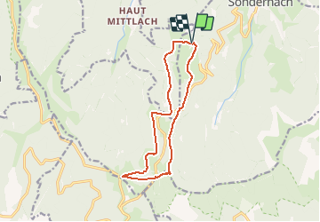
Tour Wandern von 12,1 km verfügbar auf Großer Osten, Oberelsass, Sondernach. Diese Tour wird von E.BURCK vorgeschlagen.
Beschreibung
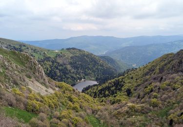
Nous partirons à 9 heures de la station de Ski du Schnepfenried pour découvrir les sommets du Nonselkopf (1237 mètres) et du Lauchenkopf (1314 mètres) d'où l'on jouit d'une vue magnifique à 360° sur la vallée de Munster, la grande crête et le versant Vosgien.
Nous rejoindrons le col du Hannenbrunnen à travers forêts et pâturages, et nous reviendrons par la ferme-Auberge Uff Rain où nous dégusterons le repas marcaire.
Après le repas nous rejoindrons le Schnepfenried par un joli chemin forestier.
Matin : 8 km, 300 mètres de dénivelé, 3 heures de marche
Après-midi : 3,4 km, 60 m de dénivelé 1 heure de marche.
Difficulté 2/5 (randonnée facile)
Les non-marcheurs pourront nous rejoindre à 12 h à la ferme-Auberge Uff Rain, accessible en voiture.
Repas marcaire au prix de 20 euros boissons en supplément. Carte bleue acceptée.
Note : nous mangerons sur la terrasse (ou dans la grange s'il pleut : prévoyez une polaire ou un coupe-vent s'il y a un peu de vent, et un chapeau s'il y a du soleil !)
Accès à la station du Schnepfenried :
A Munster prendre la route de Metzeral et continuer toujours tout droit ;
Traverser Metzeral, puis Sondernach et monter en direction de la route des crêtes.
5 km après la sortie de Sondernach, dans une épingle, prendre à droite vers la station du Schnepfenried.
Rendez-vous sur le premier parking à droite, à l'entrée de la station (petite route qui descend à droite).
Coordonnées GPS 7° 2' 53" E, 47° 59' 12" N ou en UTM32 : 354,369 E et 5 316,656 N
Accès à la Ferme-Auberge Uff Rain :
Au lieu de tourner à droite dans l'épingle, continuer encore 2,3 km et, peu après le col du Platzerwaesel, prendre le chemin à droite au panneau indicateur Uff Rain.
Coordonnées GPS 7° 1' 56" E, 47° 58' 6" N ou en UTM 32 : 353,126 E et 5 314,665 N
Ort
Kommentare
Touren in der Umgebung
![Tour Wandern Woll - Kastelberg des pierres, des lacs, des panoramas magnifiques - Photo](https://media.geolcdn.com/t/375/260/cada329c-fae7-4d3f-815e-38ed5d6ce361.jpg&format=jpg&maxdim=2)
![Wandern Wandern](https://static1.geolcdn.com/sitytour/trail-icons/101.png)
Wandern
![](/images/other/stat-length.png)
![](https://static1.geolcdn.com/siteimages/upload/files/16400158638029165_repeat_loop_refresh_sync_direction_icon.png)
![Tour Wandern Linthal - Tour de la grande Vallée de Munster (refuge du Hilsen - Munster) - Photo](https://media.geolcdn.com/t/375/260/ext.jpg?maxdim=2&url=https%3A%2F%2Fservices.sitytrail.com%2FGeolivesWS%2FDownloadMedia.ashx%3FTrailID%3D173094%26Media%3D14636_4.jpg)
![Wandern Wandern](https://static1.geolcdn.com/sitytour/trail-icons/101.png)
Wandern
![](/images/other/stat-length.png)
![](https://static1.geolcdn.com/siteimages/upload/files/16400158638029165_repeat_loop_refresh_sync_direction_icon.png)
![Tour Wandern Woll - Rainkopf - Mittlach - Hohneck - Photo](https://media.geolcdn.com/t/375/260/ext.jpg?maxdim=2&url=https%3A%2F%2Fservices.sitytrail.com%2FGeolivesWS%2FDownloadMedia.ashx%3FTrailID%3D105669%26Media%3D9489_5.jpg)
![Wandern Wandern](https://static1.geolcdn.com/sitytour/trail-icons/101.png)
Wandern
![](/images/other/stat-length.png)
![](https://static1.geolcdn.com/siteimages/upload/files/16400158638029165_repeat_loop_refresh_sync_direction_icon.png)
![Tour Mountainbike Metzeral - Tour du Gaschney par le Sattel - Photo](https://media.geolcdn.com/t/375/260/b4105d0c-3aa2-477c-bf30-5182d0c48680.jpg&format=jpg&maxdim=2)
![Mountainbike Mountainbike](https://static1.geolcdn.com/sitytour/trail-icons/202.png)
Mountainbike
![](/images/other/stat-length.png)
![](https://static1.geolcdn.com/siteimages/upload/files/16400158638029165_repeat_loop_refresh_sync_direction_icon.png)
![Tour Mountainbike Metzeral - Sentier des Névés - Photo](https://media.geolcdn.com/t/375/260/ext.jpg?maxdim=2&url=https%3A%2F%2Fservices.sitytrail.com%2FGeolivesWS%2FDownloadMedia.ashx%3FTrailID%3D100801%26Media%3D308_1.jpg)
![Mountainbike Mountainbike](https://static1.geolcdn.com/sitytour/trail-icons/202.png)
Mountainbike
![](/images/other/stat-length.png)
![](https://static1.geolcdn.com/siteimages/upload/files/16400158638029165_repeat_loop_refresh_sync_direction_icon.png)
![Tour Wandern Mittlach - 2023-09-24 Marche Mittlach 5 Lacs - Photo](https://media.geolcdn.com/t/375/260/3a2b1bda-6de8-40f1-aeb6-067a05e29c55.jpg&format=jpg&maxdim=2)
![Wandern Wandern](https://static1.geolcdn.com/sitytour/trail-icons/101.png)
Wandern
![](/images/other/stat-length.png)
![](https://static1.geolcdn.com/siteimages/upload/files/16400158638029165_repeat_loop_refresh_sync_direction_icon.png)
![Tour Wandern Sondernach - 2023-05-19 WE Marche Bivouac Massif du Hohneck - Photo](https://media.geolcdn.com/t/375/260/9808f005-4900-46c9-852c-fc244c0c6d2b.jpg&format=jpg&maxdim=2)
![Wandern Wandern](https://static1.geolcdn.com/sitytour/trail-icons/101.png)
Wandern
![](/images/other/stat-length.png)
![](https://static1.geolcdn.com/siteimages/upload/files/16400158638029165_repeat_loop_refresh_sync_direction_icon.png)
![Tour Wandern Metzeral - 2023-05-21 Marche Firstmiss vers Schnepfenried - Photo](https://media.geolcdn.com/t/375/260/66ad3a82-b4da-4aef-819b-1558093e8db9.jpg&format=jpg&maxdim=2)
![Wandern Wandern](https://static1.geolcdn.com/sitytour/trail-icons/101.png)
Wandern
![](/images/other/stat-length.png)
![](https://static1.geolcdn.com/siteimages/upload/files/16400158638029165_repeat_loop_refresh_sync_direction_icon.png)
![Tour Wandern Metzeral - 2023-05-20 Marche Lac Fischboedle vers Firstmiss - Photo](https://media.geolcdn.com/t/375/260/4c3144c9-a095-4994-9746-aac4a4c02d9d.jpg&format=jpg&maxdim=2)
![Wandern Wandern](https://static1.geolcdn.com/sitytour/trail-icons/101.png)
Wandern
![](/images/other/stat-length.png)
![](https://static1.geolcdn.com/siteimages/upload/files/16400158638029165_repeat_loop_refresh_sync_direction_icon.png)