![](/images/other/stat-length.png)
![Tour Wandern Rambures - Rambures 12 km autour du château - Photo](https://media.geolcdn.com/t/1900/400/625b09a4-2e81-4593-9453-e050c2bfd099.jpg&format=pjpeg&maxdim=2)
Rambures 12 km autour du château
MichelRando7656
Benutzer
![Länge](/images/other/stat-length.png)
Länge
12,6 km
![Maximale Höhe](https://static1.geolcdn.com/siteimages/upload/files/1508320355ic_sort_altitude_max_24dp.png)
Maximale Höhe
159 m
![Positive Höhendifferenz](https://static1.geolcdn.com/siteimages/upload/files/1508320355ic_sort_den_pos_24dp.png)
Positive Höhendifferenz
69 m
![Km-Effort](/images/other/stat-length.png)
Km-Effort
13,5 km
![Min. Höhe](https://static1.geolcdn.com/siteimages/upload/files/1508320355ic_sort_altitude_min_24dp.png)
Min. Höhe
123 m
![Negative Höhendifferenz](https://static1.geolcdn.com/siteimages/upload/files/1508320355ic_sort_den_neg_24dp.png)
Negative Höhendifferenz
68 m
![Boucle](https://static1.geolcdn.com/siteimages/upload/files/16400158638029165_repeat_loop_refresh_sync_direction_icon.png)
Boucle
Ja
Erstellungsdatum :
2019-05-30 10:53:52.846
Letzte Änderung :
2019-05-30 14:04:23.007
![Wandern](https://static1.geolcdn.com/sitytour/trail-icons/101.png)
3h09
Schwierigkeit : Sehr leicht
![Scannen Sie diesen QR-Code, um die Tour in der SityTrail-Anwendung zu öffnen](https://capi.geolives.com/qq0zvz2zws4bq2lad0pu/sitytour/trails/2098779/qr.png?size=200)
Kostenlosegpshiking-Anwendung
Über SityTrail
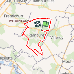
Tour Wandern von 12,6 km verfügbar auf Nordfrankreich, Somme, Rambures. Diese Tour wird von MichelRando7656 vorgeschlagen.
Beschreibung
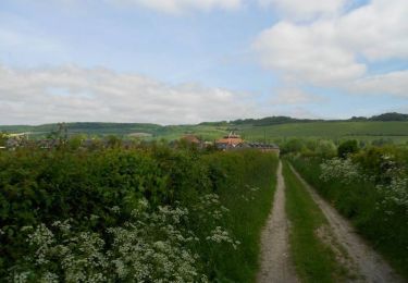
Parcours faciles en terrain plat. Nombreux chemins de cailloux ou herbeux le long des cultures de lin, blé, orge, betteraves, luzerne. Quelques petits passages sur routes goudronnés.
Ort
Land:
France
Region :
Nordfrankreich
Abteilung/Provinz :
Somme
Kommune :
Rambures
Standort:
Unknown
Gehen Sie:(Dec)
Gehen Sie:(UTM)
407303 ; 5533375 (31U) N.
Kommentare
Touren in der Umgebung
![Tour Wandern Rambures - Rambures - Château & Campagne - Photo](https://media.geolcdn.com/t/375/260/5c45805b-ab17-496b-8a44-11b4175370cd.jpg&format=jpg&maxdim=2)
![Wandern Wandern](https://static1.geolcdn.com/sitytour/trail-icons/101.png)
Rambures - Château & Campagne
Wandern
Sehr leicht
Rambures,
Nordfrankreich,
Somme,
France
![](/images/other/stat-length.png)
6,7 km | 7,3 km-effort
2h 2min
![](https://static1.geolcdn.com/siteimages/upload/files/16400158638029165_repeat_loop_refresh_sync_direction_icon.png)
Ja
![Tour Zu Fuß Nesle-Normandeuse - Circuit des Etangs - Photo](https://media.geolcdn.com/t/375/260/29978e91-7445-4990-a1cf-8b15ee5bab9e.jpeg&format=jpg&maxdim=2)
![Zu Fuß Zu Fuß](https://static1.geolcdn.com/sitytour/trail-icons/100.png)
Circuit des Etangs
Zu Fuß
Einfach
Nesle-Normandeuse,
Normandie,
Seine-Maritime,
France
![](/images/other/stat-length.png)
4,3 km | 4,9 km-effort
1h 6min
![](https://static1.geolcdn.com/siteimages/upload/files/16400158638029165_repeat_loop_refresh_sync_direction_icon.png)
Ja
![Tour Pferd Blangy-sur-Bresle - Circuit des étangs (N° 6) - Nesle-Normandeuse - Photo](https://media.geolcdn.com/t/375/260/ext.jpg?maxdim=2&url=https%3A%2F%2Fservices.sitytrail.com%2FGeolivesWS%2FDownloadMedia.ashx%3FTrailID%3D214967%26Media%3D15534_5.jpg)
![Pferd Pferd](https://static1.geolcdn.com/sitytour/trail-icons/300.png)
Circuit des étangs (N° 6) - Nesle-Normandeuse
Pferd
Einfach
Blangy-sur-Bresle,
Normandie,
Seine-Maritime,
France
![](/images/other/stat-length.png)
3,9 km | 4,5 km-effort
40min
![](https://static1.geolcdn.com/siteimages/upload/files/16400158638029165_repeat_loop_refresh_sync_direction_icon.png)
Ja
![Tour Mountainbike Blangy-sur-Bresle - Circuit des étangs (N° 6) - Nesle-Normandeuse - Photo](https://media.geolcdn.com/t/375/260/ext.jpg?maxdim=2&url=https%3A%2F%2Fservices.sitytrail.com%2FGeolivesWS%2FDownloadMedia.ashx%3FTrailID%3D214966%26Media%3D15534_5.jpg)
![Mountainbike Mountainbike](https://static1.geolcdn.com/sitytour/trail-icons/202.png)
Circuit des étangs (N° 6) - Nesle-Normandeuse
Mountainbike
Einfach
Blangy-sur-Bresle,
Normandie,
Seine-Maritime,
France
![](/images/other/stat-length.png)
3,9 km | 4,5 km-effort
19min
![](https://static1.geolcdn.com/siteimages/upload/files/16400158638029165_repeat_loop_refresh_sync_direction_icon.png)
Ja
![Tour Wandern Blangy-sur-Bresle - Circuit des étangs (N° 6) - Nesle-Normandeuse - Photo](https://media.geolcdn.com/t/375/260/ext.jpg?maxdim=2&url=https%3A%2F%2Fservices.sitytrail.com%2FGeolivesWS%2FDownloadMedia.ashx%3FTrailID%3D214965%26Media%3D15534_5.jpg)
![Wandern Wandern](https://static1.geolcdn.com/sitytour/trail-icons/101.png)
Circuit des étangs (N° 6) - Nesle-Normandeuse
Wandern
Einfach
(1)
Blangy-sur-Bresle,
Normandie,
Seine-Maritime,
France
![](/images/other/stat-length.png)
3,9 km | 4,5 km-effort
1h 0min
![](https://static1.geolcdn.com/siteimages/upload/files/16400158638029165_repeat_loop_refresh_sync_direction_icon.png)
Ja
![Tour Pferd Blangy-sur-Bresle - realiséblangy - Photo](https://media.geolcdn.com/t/375/260/ext.jpg?maxdim=2&url=https%3A%2F%2Fstatic1.geolcdn.com%2Fsiteimages%2Fupload%2Ffiles%2F1524743154cheval.jpg)
![Pferd Pferd](https://static1.geolcdn.com/sitytour/trail-icons/300.png)
realiséblangy
Pferd
Sehr schwierig
Blangy-sur-Bresle,
Normandie,
Seine-Maritime,
France
![](/images/other/stat-length.png)
32 km | 44 km-effort
5h 23min
![](https://static1.geolcdn.com/siteimages/upload/files/16400158638029165_repeat_loop_refresh_sync_direction_icon.png)
Ja