![](/images/other/stat-length.png)
![Tour Wandern Milly-la-Forêt - Coquibus - Photo](https://media.geolcdn.com/t/1900/400/f144aa12-eb62-4529-bdb7-5dac5ca4a570.jpg&format=pjpeg&maxdim=2)
Coquibus
aubr
Benutzer
![Länge](/images/other/stat-length.png)
Länge
10,3 km
![Maximale Höhe](https://static1.geolcdn.com/siteimages/upload/files/1508320355ic_sort_altitude_max_24dp.png)
Maximale Höhe
136 m
![Positive Höhendifferenz](https://static1.geolcdn.com/siteimages/upload/files/1508320355ic_sort_den_pos_24dp.png)
Positive Höhendifferenz
151 m
![Km-Effort](/images/other/stat-length.png)
Km-Effort
12,3 km
![Min. Höhe](https://static1.geolcdn.com/siteimages/upload/files/1508320355ic_sort_altitude_min_24dp.png)
Min. Höhe
73 m
![Negative Höhendifferenz](https://static1.geolcdn.com/siteimages/upload/files/1508320355ic_sort_den_neg_24dp.png)
Negative Höhendifferenz
155 m
![Boucle](https://static1.geolcdn.com/siteimages/upload/files/16400158638029165_repeat_loop_refresh_sync_direction_icon.png)
Boucle
Ja
Erstellungsdatum :
2019-05-28 07:34:02.911
Letzte Änderung :
2023-01-05 16:23:44.367
![Wandern](https://static1.geolcdn.com/sitytour/trail-icons/101.png)
2h45
Schwierigkeit : Medium
![Scannen Sie diesen QR-Code, um die Tour in der SityTrail-Anwendung zu öffnen](https://capi.geolives.com/qq0zvz2zws4bq2lad0pu/sitytour/trails/2096438/qr.png?size=200)
Kostenlosegpshiking-Anwendung
Über SityTrail
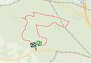
Tour Wandern von 10,3 km verfügbar auf Île-de-France, Essonne, Milly-la-Forêt. Diese Tour wird von aubr vorgeschlagen.
Beschreibung
Boucle de 11 Km au départ du Parking de la Boulignère
Sur la D837 ou voie de la Liberté
A voir "Les cents marches" et la "Feme du Coquibus"
Ort
Land:
France
Region :
Île-de-France
Abteilung/Provinz :
Essonne
Kommune :
Milly-la-Forêt
Standort:
Unknown
Gehen Sie:(Dec)
Gehen Sie:(UTM)
463555 ; 5361535 (31U) N.
Kommentare
Touren in der Umgebung
![Tour Wandern Le Vaudoué - Ultra 25 bosses - Photo](https://media.geolcdn.com/t/375/260/ext.jpg?maxdim=2&url=https%3A%2F%2Fservices.sitytrail.com%2FGeolivesWS%2FDownloadMedia.ashx%3FTrailID%3D243413%26Media%3Dfix__20140112104549.jpg)
![Wandern Wandern](https://static1.geolcdn.com/sitytour/trail-icons/101.png)
Ultra 25 bosses
Wandern
Schwierig
(1)
Le Vaudoué,
Île-de-France,
Seine-et-Marne,
France
![](/images/other/stat-length.png)
25 km | 32 km-effort
9h 2min
![](https://static1.geolcdn.com/siteimages/upload/files/16400158638029165_repeat_loop_refresh_sync_direction_icon.png)
Ja
![Tour Wandern Noisy-sur-École - M&R-121118 - 250Marches - Photo](https://media.geolcdn.com/t/375/260/ext.jpg?maxdim=2&url=https%3A%2F%2Fservices.sitytrail.com%2FGeolivesWS%2FDownloadMedia.ashx%3FTrailID%3D163348%26Media%3D20121118101634.jpeg)
![Wandern Wandern](https://static1.geolcdn.com/sitytour/trail-icons/101.png)
M&R-121118 - 250Marches
Wandern
Einfach
(1)
Noisy-sur-École,
Île-de-France,
Seine-et-Marne,
France
![](/images/other/stat-length.png)
14,3 km | 18,1 km-effort
3h 50min
![](https://static1.geolcdn.com/siteimages/upload/files/16400158638029165_repeat_loop_refresh_sync_direction_icon.png)
Ja
![Tour Wandern Milly-la-Forêt - Du parking de la Boulignère aux 100 marches via la ferme des Coquibus - Photo](https://media.geolcdn.com/t/375/260/2d4021ff-70a8-48ff-ad65-d6df60ccba59.jpg&format=jpg&maxdim=2)
![Wandern Wandern](https://static1.geolcdn.com/sitytour/trail-icons/101.png)
Du parking de la Boulignère aux 100 marches via la ferme des Coquibus
Wandern
Schwierig
(1)
Milly-la-Forêt,
Île-de-France,
Essonne,
France
![](/images/other/stat-length.png)
18,3 km | 22 km-effort
5h 0min
![](https://static1.geolcdn.com/siteimages/upload/files/16400158638029165_repeat_loop_refresh_sync_direction_icon.png)
Ja
![Tour Wandern Noisy-sur-École - Bois Rond#4 - Photo](https://media.geolcdn.com/t/375/260/7321184d-880d-445f-98b4-47f0ff0d82dd.jpg&format=jpg&maxdim=2)
![Wandern Wandern](https://static1.geolcdn.com/sitytour/trail-icons/101.png)
Bois Rond#4
Wandern
Sehr leicht
(1)
Noisy-sur-École,
Île-de-France,
Seine-et-Marne,
France
![](/images/other/stat-length.png)
8,8 km | 10,5 km-effort
2h 18min
![](https://static1.geolcdn.com/siteimages/upload/files/16400158638029165_repeat_loop_refresh_sync_direction_icon.png)
Ja
![Tour Wandern Noisy-sur-École - Les 25 Bosses - Gps en Forêt de Fontainebleau - Photo](https://media.geolcdn.com/t/375/260/ext.jpg?maxdim=2&url=https%3A%2F%2Fservices.sitytrail.com%2FGeolivesWS%2FDownloadMedia.ashx%3FTrailID%3D101528%26Media%3D1630_1.jpg)
![Wandern Wandern](https://static1.geolcdn.com/sitytour/trail-icons/101.png)
Les 25 Bosses - Gps en Forêt de Fontainebleau
Wandern
Sehr schwierig
(2)
Noisy-sur-École,
Île-de-France,
Seine-et-Marne,
France
![](/images/other/stat-length.png)
17,6 km | 23 km-effort
4h 45min
![](https://static1.geolcdn.com/siteimages/upload/files/16400158638029165_repeat_loop_refresh_sync_direction_icon.png)
Ja
![Tour Zu Fuß Milly-la-Forêt - Boucle 16 km Coquibus - Platières - Photo](https://media.geolcdn.com/t/375/260/6a2a1ae6-ffd2-44a3-8670-01d58b5995c6.jpg&format=jpg&maxdim=2)
![Zu Fuß Zu Fuß](https://static1.geolcdn.com/sitytour/trail-icons/100.png)
Boucle 16 km Coquibus - Platières
Zu Fuß
Einfach
Milly-la-Forêt,
Île-de-France,
Essonne,
France
![](/images/other/stat-length.png)
16,2 km | 19,4 km-effort
4h 24min
![](https://static1.geolcdn.com/siteimages/upload/files/16400158638029165_repeat_loop_refresh_sync_direction_icon.png)
Ja
![Tour Zu Fuß Le Vaudoué - Boucle Le Vaudoué - Photo](https://media.geolcdn.com/t/375/260/d05a3ec5-b137-48e5-a689-019375766e60.jpg&format=jpg&maxdim=2)
![Zu Fuß Zu Fuß](https://static1.geolcdn.com/sitytour/trail-icons/100.png)
Boucle Le Vaudoué
Zu Fuß
Medium
Le Vaudoué,
Île-de-France,
Seine-et-Marne,
France
![](/images/other/stat-length.png)
17,4 km | 21 km-effort
4h 47min
![](https://static1.geolcdn.com/siteimages/upload/files/16400158638029165_repeat_loop_refresh_sync_direction_icon.png)
Ja
![Tour Wandern Noisy-sur-École - Boucle 24 km Fontainebleau Arbonne - Photo](https://media.geolcdn.com/t/375/260/5aaa62f0-dc57-4770-a77a-231413885a94.jpg&format=jpg&maxdim=2)
![Wandern Wandern](https://static1.geolcdn.com/sitytour/trail-icons/101.png)
Boucle 24 km Fontainebleau Arbonne
Wandern
Einfach
Noisy-sur-École,
Île-de-France,
Seine-et-Marne,
France
![](/images/other/stat-length.png)
25 km | 31 km-effort
5h 52min
![](https://static1.geolcdn.com/siteimages/upload/files/16400158638029165_repeat_loop_refresh_sync_direction_icon.png)
Ja
![Tour Wandern Milly-la-Forêt - Boucle 29 km Milly La Forêt - Le Vaudoué - Tousson - Photo](https://media.geolcdn.com/t/375/260/3058c3db-123e-4ec5-b295-1e7b4c8ce449.jpg&format=jpg&maxdim=2)
![Wandern Wandern](https://static1.geolcdn.com/sitytour/trail-icons/101.png)
Boucle 29 km Milly La Forêt - Le Vaudoué - Tousson
Wandern
Schwierig
Milly-la-Forêt,
Île-de-France,
Essonne,
France
![](/images/other/stat-length.png)
29 km | 33 km-effort
5h 56min
![](https://static1.geolcdn.com/siteimages/upload/files/16400158638029165_repeat_loop_refresh_sync_direction_icon.png)
Ja