![](/images/other/stat-length.png)
![Tour Wandern Saint-Fortunat-sur-Eyrieux - 07 st fortunat dubieres st Vincent dufort - Photo](https://media.geolcdn.com/t/1900/400/c34c03c4-9768-4a05-aafb-3fcd76453ebb.jpg&format=pjpeg&maxdim=2)
07 st fortunat dubieres st Vincent dufort
randodyssée
Benutzer GUIDE
![Länge](/images/other/stat-length.png)
Länge
22 km
![Maximale Höhe](https://static1.geolcdn.com/siteimages/upload/files/1508320355ic_sort_altitude_max_24dp.png)
Maximale Höhe
534 m
![Positive Höhendifferenz](https://static1.geolcdn.com/siteimages/upload/files/1508320355ic_sort_den_pos_24dp.png)
Positive Höhendifferenz
838 m
![Km-Effort](/images/other/stat-length.png)
Km-Effort
33 km
![Min. Höhe](https://static1.geolcdn.com/siteimages/upload/files/1508320355ic_sort_altitude_min_24dp.png)
Min. Höhe
139 m
![Negative Höhendifferenz](https://static1.geolcdn.com/siteimages/upload/files/1508320355ic_sort_den_neg_24dp.png)
Negative Höhendifferenz
836 m
![Boucle](https://static1.geolcdn.com/siteimages/upload/files/16400158638029165_repeat_loop_refresh_sync_direction_icon.png)
Boucle
Ja
Erstellungsdatum :
2019-05-23 06:58:55.626
Letzte Änderung :
2019-05-23 15:41:57.263
![Wandern](https://static1.geolcdn.com/sitytour/trail-icons/101.png)
8h41
Schwierigkeit : Medium
![Scannen Sie diesen QR-Code, um die Tour in der SityTrail-Anwendung zu öffnen](https://capi.geolives.com/qq0zvz2zws4bq2lad0pu/sitytour/trails/2092234/qr.png?size=200)
Kostenlosegpshiking-Anwendung
Über SityTrail
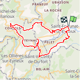
Tour Wandern von 22 km verfügbar auf Auvergne-Rhone-Alpen, Ardèche, Saint-Fortunat-sur-Eyrieux. Diese Tour wird von randodyssée vorgeschlagen.
Beschreibung
chari gene sylv
23 05 19
sympa
Ort
Land:
France
Region :
Auvergne-Rhone-Alpen
Abteilung/Provinz :
Ardèche
Kommune :
Saint-Fortunat-sur-Eyrieux
Standort:
Unknown
Gehen Sie:(Dec)
Gehen Sie:(UTM)
632556 ; 4965405 (31T) N.
Kommentare
Touren in der Umgebung
![Tour Wandern Les Ollières-sur-Eyrieux - 07 ollieres sur eyrieux Gruas - Photo](https://media.geolcdn.com/t/375/260/9ffda187-d312-43bf-86a6-ea773d0d4ffe.jpg&format=jpg&maxdim=2)
![Wandern Wandern](https://static1.geolcdn.com/sitytour/trail-icons/101.png)
07 ollieres sur eyrieux Gruas
Wandern
Medium
Les Ollières-sur-Eyrieux,
Auvergne-Rhone-Alpen,
Ardèche,
France
![](/images/other/stat-length.png)
16,5 km | 27 km-effort
7h 0min
![](https://static1.geolcdn.com/siteimages/upload/files/16400158638029165_repeat_loop_refresh_sync_direction_icon.png)
Ja
![Tour Rennrad Saint-Fortunat-sur-Eyrieux - 07 st Fortunat st agreve vv - Photo](https://media.geolcdn.com/t/375/260/8f83dac9-764a-4d77-bc61-77b94ef715b6.jpg&format=jpg&maxdim=2)
![Rennrad Rennrad](https://static1.geolcdn.com/sitytour/trail-icons/201.png)
07 st Fortunat st agreve vv
Rennrad
Medium
(1)
Saint-Fortunat-sur-Eyrieux,
Auvergne-Rhone-Alpen,
Ardèche,
France
![](/images/other/stat-length.png)
59 km | 80 km-effort
6h 31min
![](https://static1.geolcdn.com/siteimages/upload/files/16400158638029165_repeat_loop_refresh_sync_direction_icon.png)
Nein
![Tour Wandern Saint-Cierge-la-Serre - 2023-05-15_19h12m20_St Cierge La Serre 13,5km.gpx.xml - Photo](https://media.geolcdn.com/t/375/260/5f198452-8c98-4283-ab78-413b9a406c9c.jpg&format=jpg&maxdim=2)
![Wandern Wandern](https://static1.geolcdn.com/sitytour/trail-icons/101.png)
2023-05-15_19h12m20_St Cierge La Serre 13,5km.gpx.xml
Wandern
Schwierig
Saint-Cierge-la-Serre,
Auvergne-Rhone-Alpen,
Ardèche,
France
![](/images/other/stat-length.png)
13,7 km | 19,8 km-effort
4h 29min
![](https://static1.geolcdn.com/siteimages/upload/files/16400158638029165_repeat_loop_refresh_sync_direction_icon.png)
Ja
![Tour Wandern Les Ollières-sur-Eyrieux - Serré de Gruas - Photo](https://media.geolcdn.com/t/375/260/08cf67dd-d65b-4d6b-a337-2ee393033a8e.jpg&format=jpg&maxdim=2)
![Wandern Wandern](https://static1.geolcdn.com/sitytour/trail-icons/101.png)
Serré de Gruas
Wandern
Einfach
Les Ollières-sur-Eyrieux,
Auvergne-Rhone-Alpen,
Ardèche,
France
![](/images/other/stat-length.png)
16,8 km | 27 km-effort
4h 51min
![](https://static1.geolcdn.com/siteimages/upload/files/16400158638029165_repeat_loop_refresh_sync_direction_icon.png)
Ja
![Tour Wandern Les Ollières-sur-Eyrieux - la croix du banc - Photo](https://media.geolcdn.com/t/375/260/d82c3cd3-35d0-4e92-bd70-cb6fc678571a.jpg&format=jpg&maxdim=2)
![Wandern Wandern](https://static1.geolcdn.com/sitytour/trail-icons/101.png)
la croix du banc
Wandern
Medium
Les Ollières-sur-Eyrieux,
Auvergne-Rhone-Alpen,
Ardèche,
France
![](/images/other/stat-length.png)
13,6 km | 20 km-effort
4h 27min
![](https://static1.geolcdn.com/siteimages/upload/files/16400158638029165_repeat_loop_refresh_sync_direction_icon.png)
Ja
![Tour Wandern Dunière-sur-Eyrieux - Duniere reco - Photo](https://media.geolcdn.com/t/375/260/cf0e22a2-5839-4204-9a80-7596afd65d2e.jpg&format=jpg&maxdim=2)
![Wandern Wandern](https://static1.geolcdn.com/sitytour/trail-icons/101.png)
Duniere reco
Wandern
Medium
Dunière-sur-Eyrieux,
Auvergne-Rhone-Alpen,
Ardèche,
France
![](/images/other/stat-length.png)
12,4 km | 19,3 km-effort
6h 30min
![](https://static1.geolcdn.com/siteimages/upload/files/16400158638029165_repeat_loop_refresh_sync_direction_icon.png)
Ja
![Tour Wandern Saint-Fortunat-sur-Eyrieux - St Fortunat - Photo](https://media.geolcdn.com/t/375/260/381c4b81-0aa1-4f19-b6ca-35bea67274ae.jpg&format=jpg&maxdim=2)
![Wandern Wandern](https://static1.geolcdn.com/sitytour/trail-icons/101.png)
St Fortunat
Wandern
Medium
Saint-Fortunat-sur-Eyrieux,
Auvergne-Rhone-Alpen,
Ardèche,
France
![](/images/other/stat-length.png)
16,7 km | 25 km-effort
4h 38min
![](https://static1.geolcdn.com/siteimages/upload/files/16400158638029165_repeat_loop_refresh_sync_direction_icon.png)
Ja
![Tour Wandern Saint-Fortunat-sur-Eyrieux - LA Caracole. Saint-Fortunat-sur-Eyrieux - Photo](https://media.geolcdn.com/t/375/260/571461e7-0aec-4cfe-9c68-45930b9f1aa3.jpg&format=jpg&maxdim=2)
![Wandern Wandern](https://static1.geolcdn.com/sitytour/trail-icons/101.png)
LA Caracole. Saint-Fortunat-sur-Eyrieux
Wandern
Schwierig
Saint-Fortunat-sur-Eyrieux,
Auvergne-Rhone-Alpen,
Ardèche,
France
![](/images/other/stat-length.png)
18,8 km | 0 m-effort
4h 44min
![](https://static1.geolcdn.com/siteimages/upload/files/16400158638029165_repeat_loop_refresh_sync_direction_icon.png)
Nein
![Tour Wandern Saint-Julien-le-Roux - ardeche haut vivarais - Photo](https://media.geolcdn.com/t/375/260/ext.jpg?maxdim=2&url=https%3A%2F%2Fstatic1.geolcdn.com%2Fsiteimages%2Fupload%2Ffiles%2F1553511878bg_sport_marche.png)
![Wandern Wandern](https://static1.geolcdn.com/sitytour/trail-icons/101.png)
ardeche haut vivarais
Wandern
Medium
Saint-Julien-le-Roux,
Auvergne-Rhone-Alpen,
Ardèche,
France
![](/images/other/stat-length.png)
10,1 km | 13,6 km-effort
2h 35min
![](https://static1.geolcdn.com/siteimages/upload/files/16400158638029165_repeat_loop_refresh_sync_direction_icon.png)
Ja