![](/images/other/stat-length.png)
![Tour Wandern Saint-Martin-de-Valamas - Saint-Martin-de-Valamas . De pierres et d'or - Photo](https://media.geolcdn.com/t/1900/400/46d2a52a-8f9f-4ab9-bbef-28c7756eb625.jpg&format=pjpeg&maxdim=2)
Saint-Martin-de-Valamas . De pierres et d'or
bernadette revoux
Benutzer
![Länge](/images/other/stat-length.png)
Länge
24 km
![Maximale Höhe](https://static1.geolcdn.com/siteimages/upload/files/1508320355ic_sort_altitude_max_24dp.png)
Maximale Höhe
904 m
![Positive Höhendifferenz](https://static1.geolcdn.com/siteimages/upload/files/1508320355ic_sort_den_pos_24dp.png)
Positive Höhendifferenz
1179 m
![Km-Effort](/images/other/stat-length.png)
Km-Effort
39 km
![Min. Höhe](https://static1.geolcdn.com/siteimages/upload/files/1508320355ic_sort_altitude_min_24dp.png)
Min. Höhe
493 m
![Negative Höhendifferenz](https://static1.geolcdn.com/siteimages/upload/files/1508320355ic_sort_den_neg_24dp.png)
Negative Höhendifferenz
1176 m
![Boucle](https://static1.geolcdn.com/siteimages/upload/files/16400158638029165_repeat_loop_refresh_sync_direction_icon.png)
Boucle
Ja
Erstellungsdatum :
2019-05-18 06:09:36.186
Letzte Änderung :
2019-05-20 18:37:34.503
![Wandern](https://static1.geolcdn.com/sitytour/trail-icons/101.png)
6h53
Schwierigkeit : Schwierig
![Scannen Sie diesen QR-Code, um die Tour in der SityTrail-Anwendung zu öffnen](https://capi.geolives.com/qq0zvz2zws4bq2lad0pu/sitytour/trails/2087101/qr.png?size=200)
Kostenlosegpshiking-Anwendung
Über SityTrail
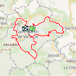
Tour Wandern von 24 km verfügbar auf Auvergne-Rhone-Alpen, Ardèche, Saint-Martin-de-Valamas. Diese Tour wird von bernadette revoux vorgeschlagen.
Beschreibung
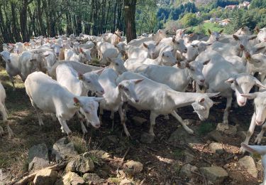
De pierres et d'or. Rando organisée par l'association "chemins oubliés des Boutières"
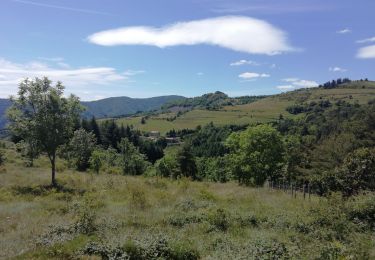
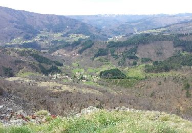
De plaines en forêt, de vallons en collines. La montagne est belle (Jean Ferrat)
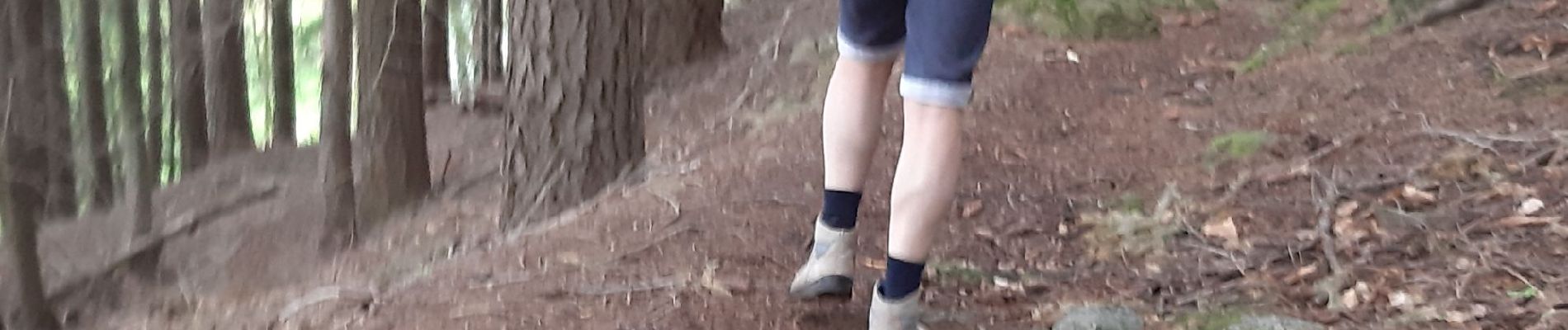
Ort
Land:
France
Region :
Auvergne-Rhone-Alpen
Abteilung/Provinz :
Ardèche
Kommune :
Saint-Martin-de-Valamas
Standort:
Unknown
Gehen Sie:(Dec)
Gehen Sie:(UTM)
608008 ; 4976710 (31T) N.
Kommentare
Touren in der Umgebung
![Tour Wandern Jaunac - Jaunac 10km - Photo](https://media.geolcdn.com/t/375/260/61afb06a-0ece-40c0-8969-cdeb0a9812fa.jpg&format=jpg&maxdim=2)
![Wandern Wandern](https://static1.geolcdn.com/sitytour/trail-icons/101.png)
Jaunac 10km
Wandern
Einfach
Jaunac,
Auvergne-Rhone-Alpen,
Ardèche,
France
![](/images/other/stat-length.png)
9,3 km | 14 km-effort
4h 38min
![](https://static1.geolcdn.com/siteimages/upload/files/16400158638029165_repeat_loop_refresh_sync_direction_icon.png)
Ja
![Tour Wandern Saint-Martin-de-Valamas - Le chemin du Brion - Photo](https://media.geolcdn.com/t/375/260/ext.jpg?maxdim=2&url=https%3A%2F%2Fstatic1.geolcdn.com%2Fsiteimages%2Fupload%2Ffiles%2F1553511878bg_sport_marche.png)
![Wandern Wandern](https://static1.geolcdn.com/sitytour/trail-icons/101.png)
Le chemin du Brion
Wandern
Schwierig
(1)
Saint-Martin-de-Valamas,
Auvergne-Rhone-Alpen,
Ardèche,
France
![](/images/other/stat-length.png)
11,8 km | 19,4 km-effort
3h 59min
![](https://static1.geolcdn.com/siteimages/upload/files/16400158638029165_repeat_loop_refresh_sync_direction_icon.png)
Ja
![Tour Wandern Le Cheylard - 20250816 - Photo](https://media.geolcdn.com/t/375/260/64fd939f-014e-49bb-86bb-39304bcea991.jpg&format=jpg&maxdim=2)
![Wandern Wandern](https://static1.geolcdn.com/sitytour/trail-icons/101.png)
20250816
Wandern
Schwierig
Le Cheylard,
Auvergne-Rhone-Alpen,
Ardèche,
France
![](/images/other/stat-length.png)
12,3 km | 16,9 km-effort
5h 20min
![](https://static1.geolcdn.com/siteimages/upload/files/16400158638029165_repeat_loop_refresh_sync_direction_icon.png)
Nein
![Tour Wandern Le Cheylard - Randonnée Le cheylard - Saint-Agrève - Lac Devesset - Photo](https://media.geolcdn.com/t/375/260/ext.jpg?maxdim=2&url=https%3A%2F%2Fstatic1.geolcdn.com%2Fsiteimages%2Fupload%2Ffiles%2F1553511878bg_sport_marche.png)
![Wandern Wandern](https://static1.geolcdn.com/sitytour/trail-icons/101.png)
Randonnée Le cheylard - Saint-Agrève - Lac Devesset
Wandern
Medium
(2)
Le Cheylard,
Auvergne-Rhone-Alpen,
Ardèche,
France
![](/images/other/stat-length.png)
34 km | 45 km-effort
9h 55min
![](https://static1.geolcdn.com/siteimages/upload/files/16400158638029165_repeat_loop_refresh_sync_direction_icon.png)
Nein
![Tour Wandern Le Cheylard - Le Cheylard -> Saint Martin de Valamas - Photo](https://media.geolcdn.com/t/375/260/ext.jpg?maxdim=2&url=https%3A%2F%2Fservices.sitytrail.com%2FGeolivesWS%2FDownloadMedia.ashx%3FTrailID%3D911165%26Media%3Dfix__20180123114120.jpg)
![Wandern Wandern](https://static1.geolcdn.com/sitytour/trail-icons/101.png)
Le Cheylard -> Saint Martin de Valamas
Wandern
Sehr leicht
Le Cheylard,
Auvergne-Rhone-Alpen,
Ardèche,
France
![](/images/other/stat-length.png)
17,4 km | 22 km-effort
5h 9min
![](https://static1.geolcdn.com/siteimages/upload/files/16400158638029165_repeat_loop_refresh_sync_direction_icon.png)
Ja
![Tour Laufen Le Cheylard - la glorie rocher de brion - Photo](https://media.geolcdn.com/t/375/260/ext.jpg?maxdim=2&url=https%3A%2F%2Fservices.sitytrail.com%2FGeolivesWS%2FDownloadMedia.ashx%3FTrailID%3D184065%26Media%3D20130410110919.jpeg)
![Laufen Laufen](https://static1.geolcdn.com/sitytour/trail-icons/103.png)
la glorie rocher de brion
Laufen
Schwierig
Le Cheylard,
Auvergne-Rhone-Alpen,
Ardèche,
France
![](/images/other/stat-length.png)
8 km | 12,6 km-effort
1h 7min
![](https://static1.geolcdn.com/siteimages/upload/files/16400158638029165_repeat_loop_refresh_sync_direction_icon.png)
Ja
![Tour Wandern Saint-Martin-de-Valamas - Saint-Martin-de-Valamas - Photo](https://media.geolcdn.com/t/375/260/17b2e24e-c281-4385-a5eb-7393745ff55c.jpg&format=jpg&maxdim=2)
![Wandern Wandern](https://static1.geolcdn.com/sitytour/trail-icons/101.png)
Saint-Martin-de-Valamas
Wandern
Medium
Saint-Martin-de-Valamas,
Auvergne-Rhone-Alpen,
Ardèche,
France
![](/images/other/stat-length.png)
12 km | 19,3 km-effort
4h 49min
![](https://static1.geolcdn.com/siteimages/upload/files/16400158638029165_repeat_loop_refresh_sync_direction_icon.png)
Ja
![Tour Wandern Mariac - Mariac-Chadenac - Photo](https://media.geolcdn.com/t/375/260/55f1b943-0565-41d9-b8b1-5e22b8cb78de.jpg&format=jpg&maxdim=2)
![Wandern Wandern](https://static1.geolcdn.com/sitytour/trail-icons/101.png)
Mariac-Chadenac
Wandern
Schwierig
Mariac,
Auvergne-Rhone-Alpen,
Ardèche,
France
![](/images/other/stat-length.png)
11,9 km | 18 km-effort
2h 22min
![](https://static1.geolcdn.com/siteimages/upload/files/16400158638029165_repeat_loop_refresh_sync_direction_icon.png)
Ja
![Tour Wandern Le Cheylard - Cheylard3 - Photo](https://media.geolcdn.com/t/375/260/f3df96e6-1a4a-420e-a093-18172795c95e.jpg&format=jpg&maxdim=2)
![Wandern Wandern](https://static1.geolcdn.com/sitytour/trail-icons/101.png)
Cheylard3
Wandern
Schwierig
Le Cheylard,
Auvergne-Rhone-Alpen,
Ardèche,
France
![](/images/other/stat-length.png)
9,1 km | 13,7 km-effort
2h 48min
![](https://static1.geolcdn.com/siteimages/upload/files/16400158638029165_repeat_loop_refresh_sync_direction_icon.png)
Nein