![](/images/other/stat-length.png)
![Tour Wandern Montignac-Charente - La rando de Puyssanganou entre Montignac et saint Amand de Boixe - Photo](https://media.geolcdn.com/t/1900/400/0f0e26a1-a6e1-462a-84d4-61dad692ae20.jpg&format=pjpeg&maxdim=2)
La rando de Puyssanganou entre Montignac et saint Amand de Boixe
alainjoseph6
Benutzer
![Länge](/images/other/stat-length.png)
Länge
10,6 km
![Maximale Höhe](https://static1.geolcdn.com/siteimages/upload/files/1508320355ic_sort_altitude_max_24dp.png)
Maximale Höhe
114 m
![Positive Höhendifferenz](https://static1.geolcdn.com/siteimages/upload/files/1508320355ic_sort_den_pos_24dp.png)
Positive Höhendifferenz
153 m
![Km-Effort](/images/other/stat-length.png)
Km-Effort
12,7 km
![Min. Höhe](https://static1.geolcdn.com/siteimages/upload/files/1508320355ic_sort_altitude_min_24dp.png)
Min. Höhe
49 m
![Negative Höhendifferenz](https://static1.geolcdn.com/siteimages/upload/files/1508320355ic_sort_den_neg_24dp.png)
Negative Höhendifferenz
157 m
![Boucle](https://static1.geolcdn.com/siteimages/upload/files/16400158638029165_repeat_loop_refresh_sync_direction_icon.png)
Boucle
Ja
Erstellungsdatum :
2019-05-02 12:15:28.817
Letzte Änderung :
2019-05-02 15:34:44.354
![Wandern](https://static1.geolcdn.com/sitytour/trail-icons/101.png)
3h18
Schwierigkeit : Medium
![Scannen Sie diesen QR-Code, um die Tour in der SityTrail-Anwendung zu öffnen](https://capi.geolives.com/qq0zvz2zws4bq2lad0pu/sitytour/trails/2070882/qr.png?size=200)
Kostenlosegpshiking-Anwendung
Über SityTrail
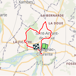
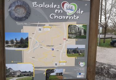
Tour Wandern von 10,6 km verfügbar auf Neu-Aquitanien, Charente, Montignac-Charente. Diese Tour wird von alainjoseph6 vorgeschlagen.
Beschreibung
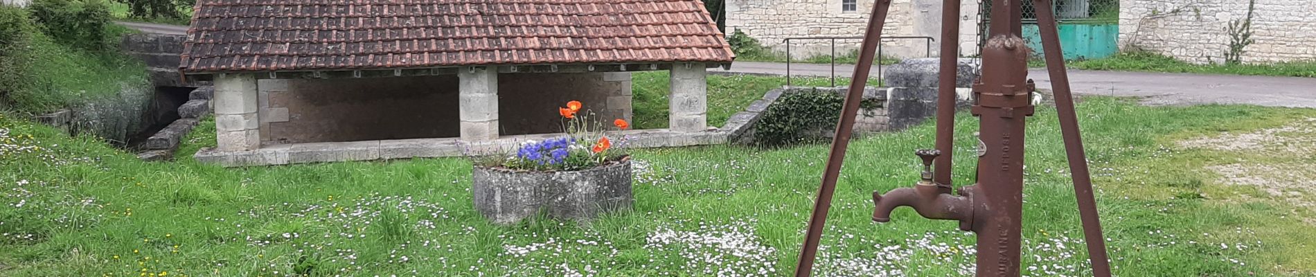
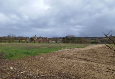
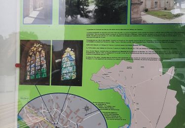
C'est une agréable rando entre la vallée de la Charente et Saint Amand de Boixe en parcourant de magnifiques chemins avec de nombreux points de vue.
Ort
Land:
France
Region :
Neu-Aquitanien
Abteilung/Provinz :
Charente
Kommune :
Montignac-Charente
Standort:
Unknown
Gehen Sie:(Dec)
Gehen Sie:(UTM)
276366 ; 5074147 (31T) N.
Kommentare
Touren in der Umgebung
![Tour Wandern Villejoubert - Villejoubert et le château de la Barre - Photo](https://media.geolcdn.com/t/375/260/907ad314-aab5-49d2-9367-f56fc4587c7a.jpg&format=jpg&maxdim=2)
![Wandern Wandern](https://static1.geolcdn.com/sitytour/trail-icons/101.png)
Villejoubert et le château de la Barre
Wandern
Medium
Villejoubert,
Neu-Aquitanien,
Charente,
France
![](/images/other/stat-length.png)
7,4 km | 8,6 km-effort
2h 17min
![](https://static1.geolcdn.com/siteimages/upload/files/16400158638029165_repeat_loop_refresh_sync_direction_icon.png)
Ja
![Tour Wandern Vouharte - Les hauts de VOUHARTE Charente - Photo](https://media.geolcdn.com/t/375/260/3c61a0db-af5d-42e2-9149-a0b6d1b08d1f.jpg&format=jpg&maxdim=2)
![Wandern Wandern](https://static1.geolcdn.com/sitytour/trail-icons/101.png)
Les hauts de VOUHARTE Charente
Wandern
Medium
Vouharte,
Neu-Aquitanien,
Charente,
France
![](/images/other/stat-length.png)
7,6 km | 9,1 km-effort
2h 56min
![](https://static1.geolcdn.com/siteimages/upload/files/16400158638029165_repeat_loop_refresh_sync_direction_icon.png)
Ja
![Tour Wandern Villejoubert - De Villejoubert à la Macarine - Photo](https://media.geolcdn.com/t/375/260/492a0f69-240e-440b-ad62-3e34775d9d25.jpg&format=jpg&maxdim=2)
![Wandern Wandern](https://static1.geolcdn.com/sitytour/trail-icons/101.png)
De Villejoubert à la Macarine
Wandern
Einfach
Villejoubert,
Neu-Aquitanien,
Charente,
France
![](/images/other/stat-length.png)
4,9 km | 5,7 km-effort
1h 51min
![](https://static1.geolcdn.com/siteimages/upload/files/16400158638029165_repeat_loop_refresh_sync_direction_icon.png)
Ja
![Tour Wandern Villejoubert - La randonnée de La Macarine - Photo](https://media.geolcdn.com/t/375/260/db059127-d362-4189-afda-718da456fa14.jpg&format=jpg&maxdim=2)
![Wandern Wandern](https://static1.geolcdn.com/sitytour/trail-icons/101.png)
La randonnée de La Macarine
Wandern
Einfach
(1)
Villejoubert,
Neu-Aquitanien,
Charente,
France
![](/images/other/stat-length.png)
10,8 km | 12,2 km-effort
3h 12min
![](https://static1.geolcdn.com/siteimages/upload/files/16400158638029165_repeat_loop_refresh_sync_direction_icon.png)
Ja
![Tour Laufen Marsac - 2023-10-15 Marsac (Charente) - Photo](https://media.geolcdn.com/t/375/260/ext.jpg?maxdim=2&url=https%3A%2F%2Fstatic1.geolcdn.com%2Fsiteimages%2Fupload%2Ffiles%2F1524743154running.jpg)
![Laufen Laufen](https://static1.geolcdn.com/sitytour/trail-icons/103.png)
2023-10-15 Marsac (Charente)
Laufen
Einfach
Marsac,
Neu-Aquitanien,
Charente,
France
![](/images/other/stat-length.png)
10 km | 12,4 km-effort
1h 4min
![](https://static1.geolcdn.com/siteimages/upload/files/16400158638029165_repeat_loop_refresh_sync_direction_icon.png)
Ja
![Tour Wandern Marsac - marsac - Photo](https://media.geolcdn.com/t/375/260/ext.jpg?maxdim=2&url=https%3A%2F%2Fstatic1.geolcdn.com%2Fsiteimages%2Fupload%2Ffiles%2F1553511878bg_sport_marche.png)
![Wandern Wandern](https://static1.geolcdn.com/sitytour/trail-icons/101.png)
marsac
Wandern
Sehr leicht
Marsac,
Neu-Aquitanien,
Charente,
France
![](/images/other/stat-length.png)
9,4 km | 11,5 km-effort
2h 28min
![](https://static1.geolcdn.com/siteimages/upload/files/16400158638029165_repeat_loop_refresh_sync_direction_icon.png)
Nein
![Tour Wandern Marsac - Marsac180220 - Photo](https://media.geolcdn.com/t/375/260/ext.jpg?maxdim=2&url=https%3A%2F%2Fstatic1.geolcdn.com%2Fsiteimages%2Fupload%2Ffiles%2F1553511878bg_sport_marche.png)
![Wandern Wandern](https://static1.geolcdn.com/sitytour/trail-icons/101.png)
Marsac180220
Wandern
Sehr leicht
Marsac,
Neu-Aquitanien,
Charente,
France
![](/images/other/stat-length.png)
11,8 km | 15,5 km-effort
3h 7min
![](https://static1.geolcdn.com/siteimages/upload/files/16400158638029165_repeat_loop_refresh_sync_direction_icon.png)
Ja
![Tour Wandern Vars - vars190120 - Photo](https://media.geolcdn.com/t/375/260/ext.jpg?maxdim=2&url=https%3A%2F%2Fstatic1.geolcdn.com%2Fsiteimages%2Fupload%2Ffiles%2F1553511878bg_sport_marche.png)
![Wandern Wandern](https://static1.geolcdn.com/sitytour/trail-icons/101.png)
vars190120
Wandern
Sehr leicht
Vars,
Neu-Aquitanien,
Charente,
France
![](/images/other/stat-length.png)
10,8 km | 13 km-effort
2h 44min
![](https://static1.geolcdn.com/siteimages/upload/files/16400158638029165_repeat_loop_refresh_sync_direction_icon.png)
Ja
![Tour Wandern Vouharte - vouharte1012 - Photo](https://media.geolcdn.com/t/375/260/ext.jpg?maxdim=2&url=https%3A%2F%2Fstatic1.geolcdn.com%2Fsiteimages%2Fupload%2Ffiles%2F1553511878bg_sport_marche.png)
![Wandern Wandern](https://static1.geolcdn.com/sitytour/trail-icons/101.png)
vouharte1012
Wandern
Sehr leicht
Vouharte,
Neu-Aquitanien,
Charente,
France
![](/images/other/stat-length.png)
11,3 km | 13,5 km-effort
2h 44min
![](https://static1.geolcdn.com/siteimages/upload/files/16400158638029165_repeat_loop_refresh_sync_direction_icon.png)
Ja