![](/images/other/stat-length.png)
![Tour Wandern Saou - Saou - Le Pré de l'Ane - Photo](https://media.geolcdn.com/t/1900/400/ext.pjpeg?maxdim=2&url=https%3A%2F%2Fstatic1.geolcdn.com%2Fsiteimages%2Fupload%2Ffiles%2F1553511878bg_sport_marche.png)
Saou - Le Pré de l'Ane
bob2023
Benutzer
![Länge](/images/other/stat-length.png)
Länge
12,4 km
![Maximale Höhe](https://static1.geolcdn.com/siteimages/upload/files/1508320355ic_sort_altitude_max_24dp.png)
Maximale Höhe
1288 m
![Positive Höhendifferenz](https://static1.geolcdn.com/siteimages/upload/files/1508320355ic_sort_den_pos_24dp.png)
Positive Höhendifferenz
838 m
![Km-Effort](/images/other/stat-length.png)
Km-Effort
24 km
![Min. Höhe](https://static1.geolcdn.com/siteimages/upload/files/1508320355ic_sort_altitude_min_24dp.png)
Min. Höhe
478 m
![Negative Höhendifferenz](https://static1.geolcdn.com/siteimages/upload/files/1508320355ic_sort_den_neg_24dp.png)
Negative Höhendifferenz
837 m
![Boucle](https://static1.geolcdn.com/siteimages/upload/files/16400158638029165_repeat_loop_refresh_sync_direction_icon.png)
Boucle
Ja
Erstellungsdatum :
2018-08-26 08:32:35.857
Letzte Änderung :
2018-08-26 08:32:35.865
![Wandern](https://static1.geolcdn.com/sitytour/trail-icons/101.png)
5h14
Schwierigkeit : Schwierig
![Scannen Sie diesen QR-Code, um die Tour in der SityTrail-Anwendung zu öffnen](https://capi.geolives.com/qq0zvz2zws4bq2lad0pu/sitytour/trails/207054/qr.png?size=200)
Kostenlosegpshiking-Anwendung
Über SityTrail
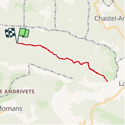
Tour Wandern von 12,4 km verfügbar auf Auvergne-Rhone-Alpen, Drôme, Saou. Diese Tour wird von bob2023 vorgeschlagen.
Beschreibung
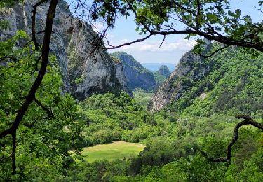
Très belle randonnée qui sillonne la Grande Combe jusqu'au Pré de l'Ane qui offre à l'arrivée une vue magnifique sur la vallée (départ à gauche sur les trois becs). Attention à la descente par le même chemin , très caillouteuse et fatigante. Note : 8/10
Ort
Land:
France
Region :
Auvergne-Rhone-Alpen
Abteilung/Provinz :
Drôme
Kommune :
Saou
Standort:
Unknown
Gehen Sie:(Dec)
Gehen Sie:(UTM)
668928 ; 4946516 (31T) N.
Kommentare
Touren in der Umgebung
![Tour Wandern Francillon-sur-Roubion - Balade à francillon sur roubion - description et photos - Photo](https://media.geolcdn.com/t/375/260/ext.jpg?maxdim=2&url=https%3A%2F%2Fservices.sitytrail.com%2FGeolivesWS%2FDownloadMedia.ashx%3FTrailID%3D656838%26Media%3Dfix__20161106144505.jpg)
![Wandern Wandern](https://static1.geolcdn.com/sitytour/trail-icons/101.png)
Balade à francillon sur roubion - description et photos
Wandern
Einfach
(1)
Francillon-sur-Roubion,
Auvergne-Rhone-Alpen,
Drôme,
France
![](/images/other/stat-length.png)
5 km | 6,7 km-effort
1h 36min
![](https://static1.geolcdn.com/siteimages/upload/files/16400158638029165_repeat_loop_refresh_sync_direction_icon.png)
Ja
![Tour Wandern Saou - roche Colombe - Photo](https://media.geolcdn.com/t/375/260/ext.jpg?maxdim=2&url=https%3A%2F%2Fservices.sitytrail.com%2FGeolivesWS%2FDownloadMedia.ashx%3FTrailID%3D528694%26Media%3Dfix__20160221163100.jpg)
![Wandern Wandern](https://static1.geolcdn.com/sitytour/trail-icons/101.png)
roche Colombe
Wandern
Medium
(1)
Saou,
Auvergne-Rhone-Alpen,
Drôme,
France
![](/images/other/stat-length.png)
10,9 km | 16,8 km-effort
3h 58min
![](https://static1.geolcdn.com/siteimages/upload/files/16400158638029165_repeat_loop_refresh_sync_direction_icon.png)
Ja
![Tour Wandern Saou - saou.les 3 becs - Photo](https://media.geolcdn.com/t/375/260/ext.jpg?maxdim=2&url=https%3A%2F%2Fservices.sitytrail.com%2FGeolivesWS%2FDownloadMedia.ashx%3FTrailID%3D329039%26Media%3Dfix__20140719140834.jpg)
![Wandern Wandern](https://static1.geolcdn.com/sitytour/trail-icons/101.png)
saou.les 3 becs
Wandern
Schwierig
(3)
Saou,
Auvergne-Rhone-Alpen,
Drôme,
France
![](/images/other/stat-length.png)
22 km | 40 km-effort
6h 46min
![](https://static1.geolcdn.com/siteimages/upload/files/16400158638029165_repeat_loop_refresh_sync_direction_icon.png)
Ja
![Tour Wandern Piégros-la-Clastre - Pas de Lauzen Col de la Chaudière - Photo](https://media.geolcdn.com/t/375/260/ext.jpg?maxdim=2&url=https%3A%2F%2Fservices.sitytrail.com%2FGeolivesWS%2FDownloadMedia.ashx%3FTrailID%3D141403%26Media%3D20120724110938.jpeg)
![Wandern Wandern](https://static1.geolcdn.com/sitytour/trail-icons/101.png)
Pas de Lauzen Col de la Chaudière
Wandern
Sehr schwierig
(1)
Piégros-la-Clastre,
Auvergne-Rhone-Alpen,
Drôme,
France
![](/images/other/stat-length.png)
19,6 km | 42 km-effort
7h 36min
![](https://static1.geolcdn.com/siteimages/upload/files/16400158638029165_repeat_loop_refresh_sync_direction_icon.png)
Nein
![Tour Wandern Saou - Les 3 Becs, le Veyou, le Signal et Rochecourbe - Photo](https://media.geolcdn.com/t/375/260/ext.jpg?maxdim=2&url=https%3A%2F%2Fservices.sitytrail.com%2FGeolivesWS%2FDownloadMedia.ashx%3FTrailID%3D103158%26Media%3D4975_2.jpg)
![Wandern Wandern](https://static1.geolcdn.com/sitytour/trail-icons/101.png)
Les 3 Becs, le Veyou, le Signal et Rochecourbe
Wandern
Schwierig
(3)
Saou,
Auvergne-Rhone-Alpen,
Drôme,
France
![](/images/other/stat-length.png)
18,5 km | 36 km-effort
8h 0min
![](https://static1.geolcdn.com/siteimages/upload/files/16400158638029165_repeat_loop_refresh_sync_direction_icon.png)
Ja
![Tour Wandern Mornans - 2024-11-19_11h34m34_FFRandonnée-Serre_Antoine - Photo](https://media.geolcdn.com/t/375/260/aebe72e3-9e3b-4ceb-b487-16517306d02c.jpg&format=jpg&maxdim=2)
![Wandern Wandern](https://static1.geolcdn.com/sitytour/trail-icons/101.png)
2024-11-19_11h34m34_FFRandonnée-Serre_Antoine
Wandern
Schwierig
Mornans,
Auvergne-Rhone-Alpen,
Drôme,
France
![](/images/other/stat-length.png)
11,4 km | 17,4 km-effort
3h 57min
![](https://static1.geolcdn.com/siteimages/upload/files/16400158638029165_repeat_loop_refresh_sync_direction_icon.png)
Ja
![Tour Rennrad Mornans - Col de Chaudiere, Saillans, Col de muse, Crupies - Photo](https://media.geolcdn.com/t/375/260/b8fcd270-be8e-430a-92ee-e05ed8f76209.jpg&format=jpg&maxdim=2)
![Rennrad Rennrad](https://static1.geolcdn.com/sitytour/trail-icons/201.png)
Col de Chaudiere, Saillans, Col de muse, Crupies
Rennrad
Schwierig
Mornans,
Auvergne-Rhone-Alpen,
Drôme,
France
![](/images/other/stat-length.png)
80 km | 105 km-effort
4h 27min
![](https://static1.geolcdn.com/siteimages/upload/files/16400158638029165_repeat_loop_refresh_sync_direction_icon.png)
Ja
![Tour Wandern Saou - 2025-02-02_17h33m51_Sur_les_traces_des_muletiers_et_des_anciennes_fermes_dans_la_Foret_de_Saou - Photo](https://media.geolcdn.com/t/375/260/8128d21a-ddf9-4165-821f-6f0f9e5ee0ba.jpg&format=jpg&maxdim=2)
![Wandern Wandern](https://static1.geolcdn.com/sitytour/trail-icons/101.png)
2025-02-02_17h33m51_Sur_les_traces_des_muletiers_et_des_anciennes_fermes_dans...
Wandern
Schwierig
Saou,
Auvergne-Rhone-Alpen,
Drôme,
France
![](/images/other/stat-length.png)
10,9 km | 15,1 km-effort
3h 25min
![](https://static1.geolcdn.com/siteimages/upload/files/16400158638029165_repeat_loop_refresh_sync_direction_icon.png)
Ja
![Tour Wandern Saou - 26 roche colombe zel - Photo](https://media.geolcdn.com/t/375/260/ade4c229-22f9-4630-ba38-8a3eb6b452f5.jpg&format=jpg&maxdim=2)
![Wandern Wandern](https://static1.geolcdn.com/sitytour/trail-icons/101.png)
26 roche colombe zel
Wandern
Medium
Saou,
Auvergne-Rhone-Alpen,
Drôme,
France
![](/images/other/stat-length.png)
13,5 km | 23 km-effort
6h 47min
![](https://static1.geolcdn.com/siteimages/upload/files/16400158638029165_repeat_loop_refresh_sync_direction_icon.png)
Nein