![](/images/other/stat-length.png)
![Tour Wandern Courpalay - Randonnées des lavoirs Courpalay - Photo](https://media.geolcdn.com/t/1900/400/ext.pjpeg?maxdim=2&url=https%3A%2F%2Fstatic1.geolcdn.com%2Fsiteimages%2Fupload%2Ffiles%2F1553511878bg_sport_marche.png)
Randonnées des lavoirs Courpalay
pikibangi
Benutzer
![Länge](/images/other/stat-length.png)
Länge
23 km
![Maximale Höhe](https://static1.geolcdn.com/siteimages/upload/files/1508320355ic_sort_altitude_max_24dp.png)
Maximale Höhe
113 m
![Positive Höhendifferenz](https://static1.geolcdn.com/siteimages/upload/files/1508320355ic_sort_den_pos_24dp.png)
Positive Höhendifferenz
194 m
![Km-Effort](/images/other/stat-length.png)
Km-Effort
25 km
![Min. Höhe](https://static1.geolcdn.com/siteimages/upload/files/1508320355ic_sort_altitude_min_24dp.png)
Min. Höhe
78 m
![Negative Höhendifferenz](https://static1.geolcdn.com/siteimages/upload/files/1508320355ic_sort_den_neg_24dp.png)
Negative Höhendifferenz
194 m
![Boucle](https://static1.geolcdn.com/siteimages/upload/files/16400158638029165_repeat_loop_refresh_sync_direction_icon.png)
Boucle
Ja
Erstellungsdatum :
2019-05-01 06:47:12.331
Letzte Änderung :
2019-05-01 16:59:50.07
![Wandern](https://static1.geolcdn.com/sitytour/trail-icons/101.png)
6h32
Schwierigkeit : Sehr leicht
![Scannen Sie diesen QR-Code, um die Tour in der SityTrail-Anwendung zu öffnen](https://capi.geolives.com/qq0zvz2zws4bq2lad0pu/sitytour/trails/2070208/qr.png?size=200)
Kostenlosegpshiking-Anwendung
Über SityTrail
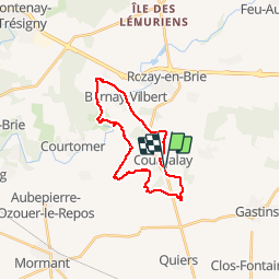
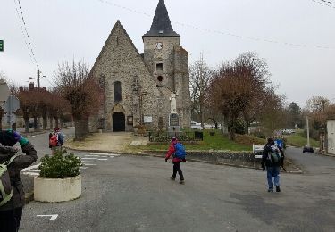
Tour Wandern von 23 km verfügbar auf Île-de-France, Seine-et-Marne, Courpalay. Diese Tour wird von pikibangi vorgeschlagen.
Beschreibung
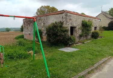
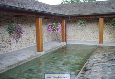
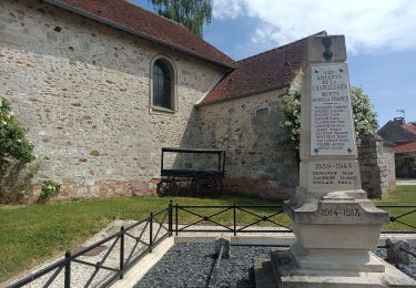
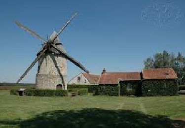
Randonnées des lavoirs au départ de Courpalay. Édition 1er mai 2019.
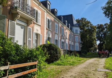
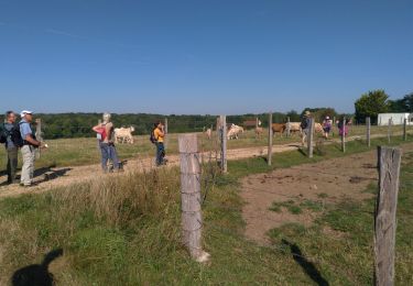
Randonnée agréable avec une belle journée ensoleillée et l'arrivée avec la bière locale, pour redonner des forces après l'effort.
Ort
Land:
France
Region :
Île-de-France
Abteilung/Provinz :
Seine-et-Marne
Kommune :
Courpalay
Standort:
Unknown
Gehen Sie:(Dec)
Gehen Sie:(UTM)
497226 ; 5388156 (31U) N.
Kommentare
Touren in der Umgebung
![Tour Wandern Courtomer - Boucle Courtomer - chaumes en Brie - - Photo](https://media.geolcdn.com/t/375/260/4c724cf3-58fd-4de3-a054-aacb416cef6c.jpg&format=jpg&maxdim=2)
![Wandern Wandern](https://static1.geolcdn.com/sitytour/trail-icons/101.png)
Boucle Courtomer - chaumes en Brie -
Wandern
Einfach
Courtomer,
Île-de-France,
Seine-et-Marne,
France
![](/images/other/stat-length.png)
20 km | 23 km-effort
4h 34min
![](https://static1.geolcdn.com/siteimages/upload/files/16400158638029165_repeat_loop_refresh_sync_direction_icon.png)
Ja
![Tour Wandern Bernay-Vilbert - Boucle de Bernay - Photo](https://media.geolcdn.com/t/375/260/0badd9bc-4790-4ce2-8ad5-41233d0a2e71.jpg&format=jpg&maxdim=2)
![Wandern Wandern](https://static1.geolcdn.com/sitytour/trail-icons/101.png)
Boucle de Bernay
Wandern
Medium
Bernay-Vilbert,
Île-de-France,
Seine-et-Marne,
France
![](/images/other/stat-length.png)
7,9 km | 9 km-effort
2h 6min
![](https://static1.geolcdn.com/siteimages/upload/files/16400158638029165_repeat_loop_refresh_sync_direction_icon.png)
Ja
![Tour Wandern La Chapelle-Iger - Les côteaux Capelligérois - La Chapelle-Iger - Photo](https://media.geolcdn.com/t/375/260/ext.jpg?maxdim=2&url=https%3A%2F%2Fservices.sitytrail.com%2FGeolivesWS%2FDownloadMedia.ashx%3FTrailID%3D111434%26Media%3D7247_3.jpg)
![Wandern Wandern](https://static1.geolcdn.com/sitytour/trail-icons/101.png)
Les côteaux Capelligérois - La Chapelle-Iger
Wandern
Schwierig
La Chapelle-Iger,
Île-de-France,
Seine-et-Marne,
France
![](/images/other/stat-length.png)
13,5 km | 15,3 km-effort
3h 19min
![](https://static1.geolcdn.com/siteimages/upload/files/16400158638029165_repeat_loop_refresh_sync_direction_icon.png)
Ja
![Tour Wandern Courpalay - courpalay - Photo](https://media.geolcdn.com/t/375/260/ext.jpg?maxdim=2&url=https%3A%2F%2Fstatic1.geolcdn.com%2Fsiteimages%2Fupload%2Ffiles%2F1553511878bg_sport_marche.png)
![Wandern Wandern](https://static1.geolcdn.com/sitytour/trail-icons/101.png)
courpalay
Wandern
Einfach
(1)
Courpalay,
Île-de-France,
Seine-et-Marne,
France
![](/images/other/stat-length.png)
13,7 km | 15,3 km-effort
3h 20min
![](https://static1.geolcdn.com/siteimages/upload/files/16400158638029165_repeat_loop_refresh_sync_direction_icon.png)
Ja
![Tour Wandern Courpalay - Courpalay - Photo](https://media.geolcdn.com/t/375/260/8b75a87c-9af5-4c3b-a34c-55caf118b693.jpg&format=jpg&maxdim=2)
![Wandern Wandern](https://static1.geolcdn.com/sitytour/trail-icons/101.png)
Courpalay
Wandern
Medium
Courpalay,
Île-de-France,
Seine-et-Marne,
France
![](/images/other/stat-length.png)
8,6 km | 9,8 km-effort
2h 39min
![](https://static1.geolcdn.com/siteimages/upload/files/16400158638029165_repeat_loop_refresh_sync_direction_icon.png)
Ja
![Tour Wandern Courpalay - SityTrail - J 96 - Randonnées des lavoirs - 19 km - Photo](https://media.geolcdn.com/t/375/260/fa54443c-4720-4cee-9756-9184d788307c.jpg&format=jpg&maxdim=2)
![Wandern Wandern](https://static1.geolcdn.com/sitytour/trail-icons/101.png)
SityTrail - J 96 - Randonnées des lavoirs - 19 km
Wandern
Schwierig
Courpalay,
Île-de-France,
Seine-et-Marne,
France
![](/images/other/stat-length.png)
19,2 km | 22 km-effort
4h 58min
![](https://static1.geolcdn.com/siteimages/upload/files/16400158638029165_repeat_loop_refresh_sync_direction_icon.png)
Ja
![Tour Wandern La Chapelle-Iger - Chapelle Iger - Photo](https://media.geolcdn.com/t/375/260/94ccf62d-3c42-4d7c-83a6-5d59eec3bc13.jpg&format=jpg&maxdim=2)
![Wandern Wandern](https://static1.geolcdn.com/sitytour/trail-icons/101.png)
Chapelle Iger
Wandern
Medium
La Chapelle-Iger,
Île-de-France,
Seine-et-Marne,
France
![](/images/other/stat-length.png)
10,2 km | 11,4 km-effort
2h 3min
![](https://static1.geolcdn.com/siteimages/upload/files/16400158638029165_repeat_loop_refresh_sync_direction_icon.png)
Ja
![Tour Wandern La Chapelle-Iger - la chapelle Iger - Photo](https://media.geolcdn.com/t/375/260/a5724690-204d-473f-ab68-a5fbec7ba8ce.jpg&format=jpg&maxdim=2)
![Wandern Wandern](https://static1.geolcdn.com/sitytour/trail-icons/101.png)
la chapelle Iger
Wandern
Schwierig
La Chapelle-Iger,
Île-de-France,
Seine-et-Marne,
France
![](/images/other/stat-length.png)
18,8 km | 21 km-effort
4h 18min
![](https://static1.geolcdn.com/siteimages/upload/files/16400158638029165_repeat_loop_refresh_sync_direction_icon.png)
Ja
![Tour Andere Aktivitäten Courpalay - courpalay - Photo](https://media.geolcdn.com/t/375/260/ext.jpg?maxdim=2&url=https%3A%2F%2Fservices.sitytrail.com%2FGeolivesWS%2FDownloadMedia.ashx%3FTrailID%3D689301%26Media%3Dfix__20170125141357.jpg)
![Andere Aktivitäten Andere Aktivitäten](https://static1.geolcdn.com/sitytour/trail-icons/900.png)
courpalay
Andere Aktivitäten
Sehr leicht
Courpalay,
Île-de-France,
Seine-et-Marne,
France
![](/images/other/stat-length.png)
16,1 km | 18,3 km-effort
3h 51min
![](https://static1.geolcdn.com/siteimages/upload/files/16400158638029165_repeat_loop_refresh_sync_direction_icon.png)
Ja