![](/images/other/stat-length.png)
![Tour Wandern Verdaches - 20190430_Sommet du Blayeul Via Verdaches - Photo](https://media.geolcdn.com/t/1900/400/ext.pjpeg?maxdim=2&url=https%3A%2F%2Fmedia.geolcdn.com%2Ff%2F768e222c-9b76-4d43-b3dd-6a6879ed04f5.jpg)
20190430_Sommet du Blayeul Via Verdaches
PapouBertrand
Benutzer
![Länge](/images/other/stat-length.png)
Länge
13,4 km
![Maximale Höhe](https://static1.geolcdn.com/siteimages/upload/files/1508320355ic_sort_altitude_max_24dp.png)
Maximale Höhe
2182 m
![Positive Höhendifferenz](https://static1.geolcdn.com/siteimages/upload/files/1508320355ic_sort_den_pos_24dp.png)
Positive Höhendifferenz
1136 m
![Km-Effort](/images/other/stat-length.png)
Km-Effort
28 km
![Min. Höhe](https://static1.geolcdn.com/siteimages/upload/files/1508320355ic_sort_altitude_min_24dp.png)
Min. Höhe
1118 m
![Negative Höhendifferenz](https://static1.geolcdn.com/siteimages/upload/files/1508320355ic_sort_den_neg_24dp.png)
Negative Höhendifferenz
1136 m
![Boucle](https://static1.geolcdn.com/siteimages/upload/files/16400158638029165_repeat_loop_refresh_sync_direction_icon.png)
Boucle
Ja
Erstellungsdatum :
2019-04-30 07:21:02.373
Letzte Änderung :
2019-06-06 17:02:35.506
![Wandern](https://static1.geolcdn.com/sitytour/trail-icons/101.png)
6h11
Schwierigkeit : Schwierig
![Scannen Sie diesen QR-Code, um die Tour in der SityTrail-Anwendung zu öffnen](https://capi.geolives.com/qq0zvz2zws4bq2lad0pu/sitytour/trails/2069059/qr.png?size=200)
Kostenlosegpshiking-Anwendung
Über SityTrail
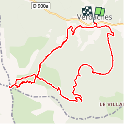
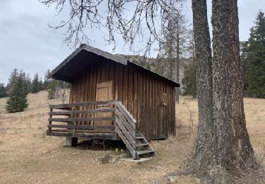
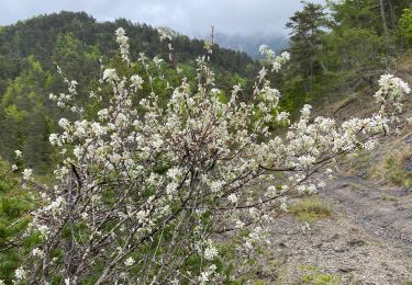
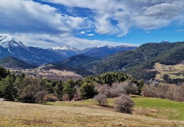
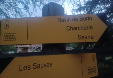
Tour Wandern von 13,4 km verfügbar auf Provence-Alpes-Côte d'Azur, Alpes-de-Haute-Provence, Verdaches. Diese Tour wird von PapouBertrand vorgeschlagen.
Beschreibung
Rando CSA Gap, au départ de Verdaches, de 6 heures, 13 KM et 1100 mètres de dénivelé avec de beaux panoramas.
Ort
Land:
France
Region :
Provence-Alpes-Côte d'Azur
Abteilung/Provinz :
Alpes-de-Haute-Provence
Kommune :
Verdaches
Standort:
Unknown
Gehen Sie:(Dec)
Gehen Sie:(UTM)
287776 ; 4904547 (32T) N.
Kommentare
Touren in der Umgebung
![Tour Wandern Beaujeu - LA JAVIE. COL DE BOUILLARD . CRETES DU BLAYEUL LED AJUSTATS . COL DE BOUILLARD N - Photo](https://media.geolcdn.com/t/375/260/ext.jpg?maxdim=2&url=https%3A%2F%2Fmedia.geolcdn.com%2Ff%2F8bfcbba1-850c-4fb5-8798-c8eac3a630fe.jpg)
![Wandern Wandern](https://static1.geolcdn.com/sitytour/trail-icons/101.png)
LA JAVIE. COL DE BOUILLARD . CRETES DU BLAYEUL LED AJUSTATS . COL DE BOUILL...
Wandern
Schwierig
Beaujeu,
Provence-Alpes-Côte d'Azur,
Alpes-de-Haute-Provence,
France
![](/images/other/stat-length.png)
12,7 km | 24 km-effort
4h 49min
![](https://static1.geolcdn.com/siteimages/upload/files/16400158638029165_repeat_loop_refresh_sync_direction_icon.png)
Ja
![Tour Wandern Le Vernet - LE VERNET . COL DU MAL D HIVER . COL DU LABOURET . O L M - Photo](https://media.geolcdn.com/t/375/260/ext.jpg?maxdim=2&url=https%3A%2F%2Fmedia.geolcdn.com%2Ff%2Ff7633ca9-7d5b-44f5-917e-1ea1f5fb10ea.jpg)
![Wandern Wandern](https://static1.geolcdn.com/sitytour/trail-icons/101.png)
LE VERNET . COL DU MAL D HIVER . COL DU LABOURET . O L M
Wandern
Medium
(1)
Le Vernet,
Provence-Alpes-Côte d'Azur,
Alpes-de-Haute-Provence,
France
![](/images/other/stat-length.png)
13 km | 17,4 km-effort
3h 17min
![](https://static1.geolcdn.com/siteimages/upload/files/16400158638029165_repeat_loop_refresh_sync_direction_icon.png)
Ja
![Tour Zu Fuß Le Vernet - Boucle route des Béliers-Le col de Mariaud-Barre des Béliers-Col de la Grisonnière-Cabane du berger - Photo](https://media.geolcdn.com/t/375/260/ext.jpg?maxdim=2&url=https%3A%2F%2Fmedia.geolcdn.com%2Ff%2F2db42dd5-9a9c-4bfd-a26c-d699435386fb.jpg)
![Zu Fuß Zu Fuß](https://static1.geolcdn.com/sitytour/trail-icons/100.png)
Boucle route des Béliers-Le col de Mariaud-Barre des Béliers-Col de la Grison...
Zu Fuß
Einfach
Le Vernet,
Provence-Alpes-Côte d'Azur,
Alpes-de-Haute-Provence,
France
![](/images/other/stat-length.png)
8,4 km | 16,3 km-effort
3h 42min
![](https://static1.geolcdn.com/siteimages/upload/files/16400158638029165_repeat_loop_refresh_sync_direction_icon.png)
Ja
![Tour Zu Fuß Le Vernet - Boucle Le Vernet-Le Haut Vernet-Le Vernet-Villevielle-Le Vernet - Photo](https://media.geolcdn.com/t/375/260/ext.jpg?maxdim=2&url=https%3A%2F%2Fmedia.geolcdn.com%2Ff%2Fb5b24fb4-ea33-4a35-899b-4bd1cd3e693f.jpg)
![Zu Fuß Zu Fuß](https://static1.geolcdn.com/sitytour/trail-icons/100.png)
Boucle Le Vernet-Le Haut Vernet-Le Vernet-Villevielle-Le Vernet
Zu Fuß
Einfach
Le Vernet,
Provence-Alpes-Côte d'Azur,
Alpes-de-Haute-Provence,
France
![](/images/other/stat-length.png)
5,8 km | 8,4 km-effort
1h 54min
![](https://static1.geolcdn.com/siteimages/upload/files/16400158638029165_repeat_loop_refresh_sync_direction_icon.png)
Ja
![Tour Wandern Le Vernet - grisonniere montagne ubac belliers960m 15kms - Photo](https://media.geolcdn.com/t/375/260/ext.jpg?maxdim=2&url=https%3A%2F%2Fmedia.geolcdn.com%2Ff%2Fbe9eca9e-a641-4422-8867-7fa326600209.jpg)
![Wandern Wandern](https://static1.geolcdn.com/sitytour/trail-icons/101.png)
grisonniere montagne ubac belliers960m 15kms
Wandern
Schwierig
Le Vernet,
Provence-Alpes-Côte d'Azur,
Alpes-de-Haute-Provence,
France
![](/images/other/stat-length.png)
14,2 km | 26 km-effort
7h 19min
![](https://static1.geolcdn.com/siteimages/upload/files/16400158638029165_repeat_loop_refresh_sync_direction_icon.png)
Ja
![Tour Wandern Le Vernet - Sommet de Grisonnière via le Vernet - Photo](https://media.geolcdn.com/t/375/260/ext.jpg?maxdim=2&url=https%3A%2F%2Fmedia.geolcdn.com%2Ff%2F94fcd9c6-ad84-44ae-85ae-450e196fc2cb.jpg)
![Wandern Wandern](https://static1.geolcdn.com/sitytour/trail-icons/101.png)
Sommet de Grisonnière via le Vernet
Wandern
Sehr schwierig
Le Vernet,
Provence-Alpes-Côte d'Azur,
Alpes-de-Haute-Provence,
France
![](/images/other/stat-length.png)
10,1 km | 20 km-effort
5h 8min
![](https://static1.geolcdn.com/siteimages/upload/files/16400158638029165_repeat_loop_refresh_sync_direction_icon.png)
Ja
![Tour Zu Fuß Verdaches - VERDACHES . BALADE DU PRE DES BOIS O L M S - Photo](https://media.geolcdn.com/t/375/260/ext.jpg?maxdim=2&url=https%3A%2F%2Fmedia.geolcdn.com%2Ff%2F16c701f7-9771-44fd-bedd-4c263ef227ac.jpg)
![Zu Fuß Zu Fuß](https://static1.geolcdn.com/sitytour/trail-icons/100.png)
VERDACHES . BALADE DU PRE DES BOIS O L M S
Zu Fuß
Einfach
Verdaches,
Provence-Alpes-Côte d'Azur,
Alpes-de-Haute-Provence,
France
![](/images/other/stat-length.png)
13,4 km | 19,2 km-effort
4h 21min
![](https://static1.geolcdn.com/siteimages/upload/files/16400158638029165_repeat_loop_refresh_sync_direction_icon.png)
Ja
![Tour Wandern Barles - BARLES . LE LAUSS . L ARDOISIERE . O - Photo](https://media.geolcdn.com/t/375/260/ext.jpg?maxdim=2&url=https%3A%2F%2Fmedia.geolcdn.com%2Ff%2F9805cbee-b075-42be-849d-cceefdf3fcf7.jpg)
![Wandern Wandern](https://static1.geolcdn.com/sitytour/trail-icons/101.png)
BARLES . LE LAUSS . L ARDOISIERE . O
Wandern
Einfach
Barles,
Provence-Alpes-Côte d'Azur,
Alpes-de-Haute-Provence,
France
![](/images/other/stat-length.png)
6,3 km | 10,4 km-effort
1h 41min
![](https://static1.geolcdn.com/siteimages/upload/files/16400158638029165_repeat_loop_refresh_sync_direction_icon.png)
Ja
![Tour Wandern Auzet - AUZET. COL DE LA PINEE . LE MARZENC . N . O L - Photo](https://media.geolcdn.com/t/375/260/ext.jpg?maxdim=2&url=https%3A%2F%2Fmedia.geolcdn.com%2Ff%2F57c3a040-1098-4fee-8a46-8cd116133a23.jpg)
![Wandern Wandern](https://static1.geolcdn.com/sitytour/trail-icons/101.png)
AUZET. COL DE LA PINEE . LE MARZENC . N . O L
Wandern
Schwierig
Auzet,
Provence-Alpes-Côte d'Azur,
Alpes-de-Haute-Provence,
France
![](/images/other/stat-length.png)
11,7 km | 22 km-effort
3h 47min
![](https://static1.geolcdn.com/siteimages/upload/files/16400158638029165_repeat_loop_refresh_sync_direction_icon.png)
Ja