![](/images/other/stat-length.png)
![Tour Wandern Wissant - WISSANT vers CAP BLANC NEZ - Photo](https://media.geolcdn.com/t/1900/400/ext.pjpeg?maxdim=2&url=https%3A%2F%2Fstatic1.geolcdn.com%2Fsiteimages%2Fupload%2Ffiles%2F1553511878bg_sport_marche.png)
WISSANT vers CAP BLANC NEZ
BVB
Benutzer
![Länge](/images/other/stat-length.png)
Länge
16,6 km
![Maximale Höhe](https://static1.geolcdn.com/siteimages/upload/files/1508320355ic_sort_altitude_max_24dp.png)
Maximale Höhe
130 m
![Positive Höhendifferenz](https://static1.geolcdn.com/siteimages/upload/files/1508320355ic_sort_den_pos_24dp.png)
Positive Höhendifferenz
301 m
![Km-Effort](/images/other/stat-length.png)
Km-Effort
21 km
![Min. Höhe](https://static1.geolcdn.com/siteimages/upload/files/1508320355ic_sort_altitude_min_24dp.png)
Min. Höhe
-1 m
![Negative Höhendifferenz](https://static1.geolcdn.com/siteimages/upload/files/1508320355ic_sort_den_neg_24dp.png)
Negative Höhendifferenz
301 m
![Boucle](https://static1.geolcdn.com/siteimages/upload/files/16400158638029165_repeat_loop_refresh_sync_direction_icon.png)
Boucle
Ja
Erstellungsdatum :
2019-04-27 09:14:40.0
Letzte Änderung :
2019-04-27 15:10:04.144
![Wandern](https://static1.geolcdn.com/sitytour/trail-icons/101.png)
4h09
Schwierigkeit : Schwierig
![Scannen Sie diesen QR-Code, um die Tour in der SityTrail-Anwendung zu öffnen](https://capi.geolives.com/qq0zvz2zws4bq2lad0pu/sitytour/trails/2067665/qr.png?size=200)
Kostenlosegpshiking-Anwendung
Über SityTrail
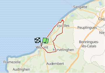
Tour Wandern von 16,6 km verfügbar auf Nordfrankreich, Pas-de-Calais, Wissant. Diese Tour wird von BVB vorgeschlagen.
Beschreibung
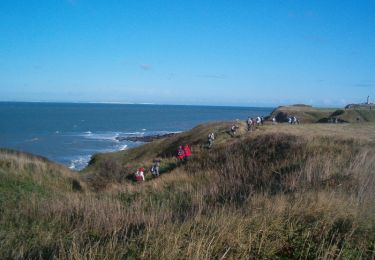
Belle promenade au bord de la mer puis à travers champs. Il est préférable de partir à marée basse et avec le vent dans le dos
Ort
Land:
France
Region :
Nordfrankreich
Abteilung/Provinz :
Pas-de-Calais
Kommune :
Wissant
Standort:
Unknown
Gehen Sie:(Dec)
Gehen Sie:(UTM)
405942 ; 5637973 (31U) N.
Kommentare
Touren in der Umgebung
![Tour Wandern Wissant - Wissant-Mont de Couple- retour par la plage - Photo](https://media.geolcdn.com/t/375/260/6a90087b-5622-41da-a3b9-e42ff4ae0e92.jpg&format=jpg&maxdim=2)
![Wandern Wandern](https://static1.geolcdn.com/sitytour/trail-icons/101.png)
Wissant-Mont de Couple- retour par la plage
Wandern
Schwierig
(1)
Wissant,
Nordfrankreich,
Pas-de-Calais,
France
![](/images/other/stat-length.png)
14,3 km | 0 m-effort
2h 53min
![](https://static1.geolcdn.com/siteimages/upload/files/16400158638029165_repeat_loop_refresh_sync_direction_icon.png)
Ja
![Tour Wandern Wissant - Le Fartz - Photo](https://media.geolcdn.com/t/375/260/21ada877-513c-478a-b332-d0dc0a2aace8.jpg&format=jpg&maxdim=2)
![Wandern Wandern](https://static1.geolcdn.com/sitytour/trail-icons/101.png)
Le Fartz
Wandern
Sehr leicht
(1)
Wissant,
Nordfrankreich,
Pas-de-Calais,
France
![](/images/other/stat-length.png)
5,5 km | 6,2 km-effort
1h 29min
![](https://static1.geolcdn.com/siteimages/upload/files/16400158638029165_repeat_loop_refresh_sync_direction_icon.png)
Ja
![Tour Wandern Escalles - Les balcons d'Escalles - Photo](https://media.geolcdn.com/t/375/260/ext.jpg?maxdim=2&url=https%3A%2F%2Fservices.sitytrail.com%2FGeolivesWS%2FDownloadMedia.ashx%3FTrailID%3D110282%26Media%3D5677_6.jpg)
![Wandern Wandern](https://static1.geolcdn.com/sitytour/trail-icons/101.png)
Les balcons d'Escalles
Wandern
Medium
(5)
Escalles,
Nordfrankreich,
Pas-de-Calais,
France
![](/images/other/stat-length.png)
7,8 km | 10,5 km-effort
2h 0min
![](https://static1.geolcdn.com/siteimages/upload/files/16400158638029165_repeat_loop_refresh_sync_direction_icon.png)
Ja
![Tour Wandern Sangatte - Le Site des 2 Caps - Les Falaises du Cap Blanc Nez et le Mont d'Hubert - Photo](https://media.geolcdn.com/t/375/260/ext.jpg?maxdim=2&url=https%3A%2F%2Fservices.sitytrail.com%2FGeolivesWS%2FDownloadMedia.ashx%3FTrailID%3D109468%26Media%3D4011_6.jpg)
![Wandern Wandern](https://static1.geolcdn.com/sitytour/trail-icons/101.png)
Le Site des 2 Caps - Les Falaises du Cap Blanc Nez et le Mont d'Hubert
Wandern
Medium
(3)
Sangatte,
Nordfrankreich,
Pas-de-Calais,
France
![](/images/other/stat-length.png)
11,2 km | 14,7 km-effort
3h 0min
![](https://static1.geolcdn.com/siteimages/upload/files/16400158638029165_repeat_loop_refresh_sync_direction_icon.png)
Ja
![Tour Wandern Tardinghen - Le Site des 2 Caps - Le Sentier des Crans - Photo](https://media.geolcdn.com/t/375/260/ext.jpg?maxdim=2&url=https%3A%2F%2Fservices.sitytrail.com%2FGeolivesWS%2FDownloadMedia.ashx%3FTrailID%3D109462%26Media%3D3985_6.jpg)
![Wandern Wandern](https://static1.geolcdn.com/sitytour/trail-icons/101.png)
Le Site des 2 Caps - Le Sentier des Crans
Wandern
Medium
(2)
Tardinghen,
Nordfrankreich,
Pas-de-Calais,
France
![](/images/other/stat-length.png)
12 km | 14,3 km-effort
3h 0min
![](https://static1.geolcdn.com/siteimages/upload/files/16400158638029165_repeat_loop_refresh_sync_direction_icon.png)
Ja
![Tour Wandern Tardinghen - Sentier du Fartz - Waissant - Photo](https://media.geolcdn.com/t/375/260/ext.jpg?maxdim=2&url=https%3A%2F%2Fservices.sitytrail.com%2FGeolivesWS%2FDownloadMedia.ashx%3FTrailID%3D106661%26Media%3D11281_6.jpg)
![Wandern Wandern](https://static1.geolcdn.com/sitytour/trail-icons/101.png)
Sentier du Fartz - Waissant
Wandern
Einfach
(1)
Tardinghen,
Nordfrankreich,
Pas-de-Calais,
France
![](/images/other/stat-length.png)
5,1 km | 5,8 km-effort
1h 30min
![](https://static1.geolcdn.com/siteimages/upload/files/16400158638029165_repeat_loop_refresh_sync_direction_icon.png)
Ja
![Tour Wandern Tardinghen - Le Site des 2 Caps - Le Sentier des Crans - Photo](https://media.geolcdn.com/t/375/260/ext.jpg?maxdim=2&url=https%3A%2F%2Fstatic1.geolcdn.com%2Fsiteimages%2Fupload%2Ffiles%2F1553511878bg_sport_marche.png)
![Wandern Wandern](https://static1.geolcdn.com/sitytour/trail-icons/101.png)
Le Site des 2 Caps - Le Sentier des Crans
Wandern
Einfach
(3)
Tardinghen,
Nordfrankreich,
Pas-de-Calais,
France
![](/images/other/stat-length.png)
12 km | 14,3 km-effort
3h 0min
![](https://static1.geolcdn.com/siteimages/upload/files/16400158638029165_repeat_loop_refresh_sync_direction_icon.png)
Ja
![Tour Wandern Wissant - Le Site des 2 Caps - Le Sentier du Phartz et de la Dune d'Aval - Photo](https://media.geolcdn.com/t/375/260/ext.jpg?maxdim=2&url=https%3A%2F%2Fstatic1.geolcdn.com%2Fsiteimages%2Fupload%2Ffiles%2F1553511878bg_sport_marche.png)
![Wandern Wandern](https://static1.geolcdn.com/sitytour/trail-icons/101.png)
Le Site des 2 Caps - Le Sentier du Phartz et de la Dune d'Aval
Wandern
Einfach
(3)
Wissant,
Nordfrankreich,
Pas-de-Calais,
France
![](/images/other/stat-length.png)
7,4 km | 8,3 km-effort
1h 50min
![](https://static1.geolcdn.com/siteimages/upload/files/16400158638029165_repeat_loop_refresh_sync_direction_icon.png)
Ja
![Tour Wandern Sangatte - Le Site des 2 Caps - Les Falaises du Cap Blanc Nez et le Mont d'Hubert - Photo](https://media.geolcdn.com/t/375/260/ext.jpg?maxdim=2&url=https%3A%2F%2Fstatic1.geolcdn.com%2Fsiteimages%2Fupload%2Ffiles%2F1553511878bg_sport_marche.png)
![Wandern Wandern](https://static1.geolcdn.com/sitytour/trail-icons/101.png)
Le Site des 2 Caps - Les Falaises du Cap Blanc Nez et le Mont d'Hubert
Wandern
Einfach
(4)
Sangatte,
Nordfrankreich,
Pas-de-Calais,
France
![](/images/other/stat-length.png)
11,2 km | 14,7 km-effort
2h 50min
![](https://static1.geolcdn.com/siteimages/upload/files/16400158638029165_repeat_loop_refresh_sync_direction_icon.png)
Ja