![](/images/other/stat-length.png)
![Tour Wandern Orgnac-sur-Vézère - Orgnac - Photo](https://media.geolcdn.com/t/1900/400/ext.pjpeg?maxdim=2&url=https%3A%2F%2Fstatic1.geolcdn.com%2Fsiteimages%2Fupload%2Ffiles%2F1553511878bg_sport_marche.png)
Orgnac
houbart
Benutzer
![Länge](/images/other/stat-length.png)
Länge
8,4 km
![Maximale Höhe](https://static1.geolcdn.com/siteimages/upload/files/1508320355ic_sort_altitude_max_24dp.png)
Maximale Höhe
369 m
![Positive Höhendifferenz](https://static1.geolcdn.com/siteimages/upload/files/1508320355ic_sort_den_pos_24dp.png)
Positive Höhendifferenz
310 m
![Km-Effort](/images/other/stat-length.png)
Km-Effort
12,5 km
![Min. Höhe](https://static1.geolcdn.com/siteimages/upload/files/1508320355ic_sort_altitude_min_24dp.png)
Min. Höhe
195 m
![Negative Höhendifferenz](https://static1.geolcdn.com/siteimages/upload/files/1508320355ic_sort_den_neg_24dp.png)
Negative Höhendifferenz
309 m
![Boucle](https://static1.geolcdn.com/siteimages/upload/files/16400158638029165_repeat_loop_refresh_sync_direction_icon.png)
Boucle
Ja
Erstellungsdatum :
2019-04-12 16:11:24.1
Letzte Änderung :
2019-04-12 16:23:46.683
![Wandern](https://static1.geolcdn.com/sitytour/trail-icons/101.png)
2h36
Schwierigkeit : Medium
![Scannen Sie diesen QR-Code, um die Tour in der SityTrail-Anwendung zu öffnen](https://capi.geolives.com/qq0zvz2zws4bq2lad0pu/sitytour/trails/2060728/qr.png?size=200)
Kostenlosegpshiking-Anwendung
Über SityTrail
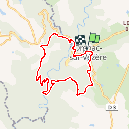
Tour Wandern von 8,4 km verfügbar auf Neu-Aquitanien, Corrèze, Orgnac-sur-Vézère. Diese Tour wird von houbart vorgeschlagen.
Beschreibung
Au point de départ, on peut admirer les vitraux de Kim En Joong, de l'église Saint-Martial. Balade dans les bois puis le long de la Loyre, hauts lieux de la Résistance (stèle).
Ort
Land:
France
Region :
Neu-Aquitanien
Abteilung/Provinz :
Corrèze
Kommune :
Orgnac-sur-Vézère
Standort:
Unknown
Gehen Sie:(Dec)
Gehen Sie:(UTM)
377860 ; 5020989 (31T) N.
Kommentare
Touren in der Umgebung
![Wandern Wandern](https://static1.geolcdn.com/sitytour/trail-icons/101.png)
Estivaux_Le Saillant-Gorges de la Vézère
Wandern
Schwierig
Estivaux,
Neu-Aquitanien,
Corrèze,
France
![](/images/other/stat-length.png)
20 km | 30 km-effort
6h 0min
![](https://static1.geolcdn.com/siteimages/upload/files/16400158638029165_repeat_loop_refresh_sync_direction_icon.png)
Ja
![Tour Wandern Voutezac - Ayen-160623 - Ceyrat-FontaineCrozes - Photo](https://media.geolcdn.com/t/375/260/ext.jpg?maxdim=2&url=https%3A%2F%2Fservices.sitytrail.com%2FGeolivesWS%2FDownloadMedia.ashx%3FTrailID%3D588114%26Media%3Dfix__20160623115501.jpg)
![Wandern Wandern](https://static1.geolcdn.com/sitytour/trail-icons/101.png)
Ayen-160623 - Ceyrat-FontaineCrozes
Wandern
Medium
Voutezac,
Neu-Aquitanien,
Corrèze,
France
![](/images/other/stat-length.png)
7,5 km | 10,7 km-effort
2h 35min
![](https://static1.geolcdn.com/siteimages/upload/files/16400158638029165_repeat_loop_refresh_sync_direction_icon.png)
Ja
![Tour Wandern Voutezac - Les coteaux de Vertougit - Voutezac - Photo](https://media.geolcdn.com/t/375/260/ext.jpg?maxdim=2&url=https%3A%2F%2Fservices.sitytrail.com%2FGeolivesWS%2FDownloadMedia.ashx%3FTrailID%3D318028%26Media%3D17491_3.jpg)
![Wandern Wandern](https://static1.geolcdn.com/sitytour/trail-icons/101.png)
Les coteaux de Vertougit - Voutezac
Wandern
Medium
Voutezac,
Neu-Aquitanien,
Corrèze,
France
![](/images/other/stat-length.png)
10,9 km | 15,3 km-effort
3h 30min
![](https://static1.geolcdn.com/siteimages/upload/files/16400158638029165_repeat_loop_refresh_sync_direction_icon.png)
Ja
![Tour Wandern Voutezac - La fontaine des Crozes - Voutezac - Photo](https://media.geolcdn.com/t/375/260/ext.jpg?maxdim=2&url=https%3A%2F%2Fservices.sitytrail.com%2FGeolivesWS%2FDownloadMedia.ashx%3FTrailID%3D318027%26Media%3D17490_3.jpg)
![Wandern Wandern](https://static1.geolcdn.com/sitytour/trail-icons/101.png)
La fontaine des Crozes - Voutezac
Wandern
Schwierig
(1)
Voutezac,
Neu-Aquitanien,
Corrèze,
France
![](/images/other/stat-length.png)
11,8 km | 16,7 km-effort
3h 0min
![](https://static1.geolcdn.com/siteimages/upload/files/16400158638029165_repeat_loop_refresh_sync_direction_icon.png)
Ja
![Wandern Wandern](https://static1.geolcdn.com/sitytour/trail-icons/101.png)
Gorges de la Vézère : Boucle Comborn-le Saillant
Wandern
Sehr schwierig
Orgnac-sur-Vézère,
Neu-Aquitanien,
Corrèze,
France
![](/images/other/stat-length.png)
21 km | 32 km-effort
7h 13min
![](https://static1.geolcdn.com/siteimages/upload/files/16400158638029165_repeat_loop_refresh_sync_direction_icon.png)
Ja
![Wandern Wandern](https://static1.geolcdn.com/sitytour/trail-icons/101.png)
Vignols - La sagne
Wandern
Medium
Vignols,
Neu-Aquitanien,
Corrèze,
France
![](/images/other/stat-length.png)
7,8 km | 10,5 km-effort
2h 16min
![](https://static1.geolcdn.com/siteimages/upload/files/16400158638029165_repeat_loop_refresh_sync_direction_icon.png)
Ja
![Wandern Wandern](https://static1.geolcdn.com/sitytour/trail-icons/101.png)
Orgnac - Pommier-Gorges Vézère
Wandern
Sehr leicht
Orgnac-sur-Vézère,
Neu-Aquitanien,
Corrèze,
France
![](/images/other/stat-length.png)
6,7 km | 9,3 km-effort
1h 59min
![](https://static1.geolcdn.com/siteimages/upload/files/16400158638029165_repeat_loop_refresh_sync_direction_icon.png)
Ja
![Tour Wandern Beyssac - Beyssac (19230)- Chartreuse du Glandier et Canal des moines - Photo](https://media.geolcdn.com/t/375/260/ext.jpg?maxdim=2&url=https%3A%2F%2Fservices.sitytrail.com%2FGeolivesWS%2FDownloadMedia.ashx%3FTrailID%3D1049026%26Media%3D8558f252-1a38-414b-9a0d-e1468deabb1c.JPG)
![Wandern Wandern](https://static1.geolcdn.com/sitytour/trail-icons/101.png)
Beyssac (19230)- Chartreuse du Glandier et Canal des moines
Wandern
Sehr leicht
(1)
Beyssac,
Neu-Aquitanien,
Corrèze,
France
![](/images/other/stat-length.png)
4,6 km | 6,4 km-effort
1h 13min
![](https://static1.geolcdn.com/siteimages/upload/files/16400158638029165_repeat_loop_refresh_sync_direction_icon.png)
Ja
![Tour Wandern Estivaux - Estivaux- Sentier nature - Photo](https://media.geolcdn.com/t/375/260/ext.jpg?maxdim=2&url=https%3A%2F%2Fservices.sitytrail.com%2FGeolivesWS%2FDownloadMedia.ashx%3FTrailID%3D560609%26Media%3D0d9a9319-a910-41c4-af86-1d675d86f384.JPG)
![Wandern Wandern](https://static1.geolcdn.com/sitytour/trail-icons/101.png)
Estivaux- Sentier nature
Wandern
Einfach
(1)
Estivaux,
Neu-Aquitanien,
Corrèze,
France
![](/images/other/stat-length.png)
3,5 km | 5,2 km-effort
1h 0min
![](https://static1.geolcdn.com/siteimages/upload/files/16400158638029165_repeat_loop_refresh_sync_direction_icon.png)
Ja