![](/images/other/stat-length.png)
![Tour Mountainbike Saint-Nazaire-le-Désert - Tour Blaï Chamauche Blaï [be Nomade] - Photo](https://media.geolcdn.com/t/1900/400/ext.pjpeg?maxdim=2&url=https%3A%2F%2Fstatic1.geolcdn.com%2Fsiteimages%2Fupload%2Ffiles%2F1524743154velo.jpg)
Tour Blaï Chamauche Blaï [be Nomade]
nico_be
Benutzer
![Länge](/images/other/stat-length.png)
Länge
35 km
![Maximale Höhe](https://static1.geolcdn.com/siteimages/upload/files/1508320355ic_sort_altitude_max_24dp.png)
Maximale Höhe
1037 m
![Positive Höhendifferenz](https://static1.geolcdn.com/siteimages/upload/files/1508320355ic_sort_den_pos_24dp.png)
Positive Höhendifferenz
896 m
![Km-Effort](/images/other/stat-length.png)
Km-Effort
47 km
![Min. Höhe](https://static1.geolcdn.com/siteimages/upload/files/1508320355ic_sort_altitude_min_24dp.png)
Min. Höhe
672 m
![Negative Höhendifferenz](https://static1.geolcdn.com/siteimages/upload/files/1508320355ic_sort_den_neg_24dp.png)
Negative Höhendifferenz
892 m
![Boucle](https://static1.geolcdn.com/siteimages/upload/files/16400158638029165_repeat_loop_refresh_sync_direction_icon.png)
Boucle
Ja
Erstellungsdatum :
2019-04-11 14:26:22.197
Letzte Änderung :
2019-04-11 18:43:49.63
![Mountainbike](https://static1.geolcdn.com/sitytour/trail-icons/202.png)
4h00
Schwierigkeit : Einfach
![Elektrofahrrad](https://static1.geolcdn.com/sitytour/trail-icons/205.png)
3h13
Schwierigkeit : Einfach
![Scannen Sie diesen QR-Code, um die Tour in der SityTrail-Anwendung zu öffnen](https://capi.geolives.com/qq0zvz2zws4bq2lad0pu/sitytour/trails/2060376/qr.png?size=200)
Kostenlosegpshiking-Anwendung
Über SityTrail
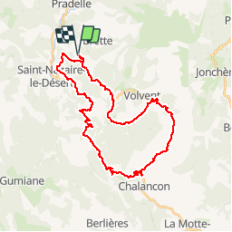
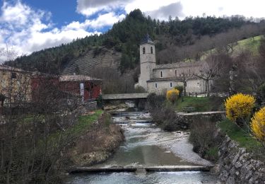
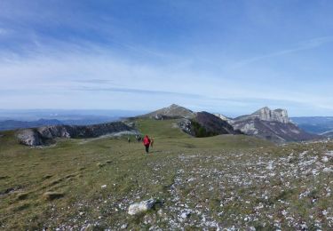
Tour Mountainbike von 35 km verfügbar auf Auvergne-Rhone-Alpen, Drôme, Saint-Nazaire-le-Désert. Diese Tour wird von nico_be vorgeschlagen.
Beschreibung
Balade tranquille en VTT électriques loués chez Be Nomade a St Nazaire le Desert 33 6 59 19 09 35. Super équipe a conseiller!
Ort
Land:
France
Region :
Auvergne-Rhone-Alpen
Abteilung/Provinz :
Drôme
Kommune :
Saint-Nazaire-le-Désert
Standort:
Unknown
Gehen Sie:(Dec)
Gehen Sie:(UTM)
682366 ; 4938869 (31T) N.
Kommentare
Touren in der Umgebung
![Tour Wandern Saint-Nazaire-le-Désert - 26 st Nazaire le desert - Photo](https://media.geolcdn.com/t/375/260/800f793b-c8e6-438c-bf52-c0a833bbf3e1.jpg&format=jpg&maxdim=2)
![Wandern Wandern](https://static1.geolcdn.com/sitytour/trail-icons/101.png)
26 st Nazaire le desert
Wandern
Sehr schwierig
Saint-Nazaire-le-Désert,
Auvergne-Rhone-Alpen,
Drôme,
France
![](/images/other/stat-length.png)
8,5 km | 16 km-effort
5h 17min
![](https://static1.geolcdn.com/siteimages/upload/files/16400158638029165_repeat_loop_refresh_sync_direction_icon.png)
Nein
![Tour Wandern Saint-Nazaire-le-Désert - Bergerie du Pradaux - Photo](https://media.geolcdn.com/t/375/260/ext.jpg?maxdim=2&url=https%3A%2F%2Fstatic1.geolcdn.com%2Fsiteimages%2Fupload%2Ffiles%2F1553511878bg_sport_marche.png)
![Wandern Wandern](https://static1.geolcdn.com/sitytour/trail-icons/101.png)
Bergerie du Pradaux
Wandern
Medium
(1)
Saint-Nazaire-le-Désert,
Auvergne-Rhone-Alpen,
Drôme,
France
![](/images/other/stat-length.png)
12,5 km | 22 km-effort
4h 42min
![](https://static1.geolcdn.com/siteimages/upload/files/16400158638029165_repeat_loop_refresh_sync_direction_icon.png)
Ja
![Tour Wandern Volvent - 26 chalencon eyriau zel - Photo](https://media.geolcdn.com/t/375/260/153502c6-6d0b-49a9-b8eb-15eb863bb322.jpg&format=jpg&maxdim=2)
![Wandern Wandern](https://static1.geolcdn.com/sitytour/trail-icons/101.png)
26 chalencon eyriau zel
Wandern
Medium
Volvent,
Auvergne-Rhone-Alpen,
Drôme,
France
![](/images/other/stat-length.png)
12,9 km | 23 km-effort
6h 13min
![](https://static1.geolcdn.com/siteimages/upload/files/16400158638029165_repeat_loop_refresh_sync_direction_icon.png)
Nein
![Tour Wandern Rochefourchat - Serre Délégué depuis Rochefourchat 15 10 23 - Photo](https://media.geolcdn.com/t/375/260/dd32defb-f16e-4dda-98b5-10da95afa891.jpg&format=jpg&maxdim=2)
![Wandern Wandern](https://static1.geolcdn.com/sitytour/trail-icons/101.png)
Serre Délégué depuis Rochefourchat 15 10 23
Wandern
Medium
Rochefourchat,
Auvergne-Rhone-Alpen,
Drôme,
France
![](/images/other/stat-length.png)
14,3 km | 25 km-effort
4h 29min
![](https://static1.geolcdn.com/siteimages/upload/files/16400158638029165_repeat_loop_refresh_sync_direction_icon.png)
Ja
![Tour Wandern Saint-Nazaire-le-Désert - Saint Nazaire le Désert - Photo](https://media.geolcdn.com/t/375/260/727e7242-c051-4080-9ece-fd964be15596.jpg&format=jpg&maxdim=2)
![Wandern Wandern](https://static1.geolcdn.com/sitytour/trail-icons/101.png)
Saint Nazaire le Désert
Wandern
Einfach
Saint-Nazaire-le-Désert,
Auvergne-Rhone-Alpen,
Drôme,
France
![](/images/other/stat-length.png)
12,4 km | 21 km-effort
3h 44min
![](https://static1.geolcdn.com/siteimages/upload/files/16400158638029165_repeat_loop_refresh_sync_direction_icon.png)
Ja
![Tour Wandern Rochefourchat - Grand Delmas depuis Rochefourchat - Photo](https://media.geolcdn.com/t/375/260/d54b38a2-4988-4640-bf17-e0e6b4ff0960.jpg&format=jpg&maxdim=2)
![Wandern Wandern](https://static1.geolcdn.com/sitytour/trail-icons/101.png)
Grand Delmas depuis Rochefourchat
Wandern
Medium
Rochefourchat,
Auvergne-Rhone-Alpen,
Drôme,
France
![](/images/other/stat-length.png)
16,6 km | 28 km-effort
5h 25min
![](https://static1.geolcdn.com/siteimages/upload/files/16400158638029165_repeat_loop_refresh_sync_direction_icon.png)
Ja
![Tour Schneeschuhwandern Volvent - Servelle de Brette - Photo](https://media.geolcdn.com/t/375/260/049a8df2-2b16-40b5-a9d0-094d00ba47da.jpg&format=jpg&maxdim=2)
![Schneeschuhwandern Schneeschuhwandern](https://static1.geolcdn.com/sitytour/trail-icons/504.png)
Servelle de Brette
Schneeschuhwandern
Medium
Volvent,
Auvergne-Rhone-Alpen,
Drôme,
France
![](/images/other/stat-length.png)
14,8 km | 25 km-effort
4h 4min
![](https://static1.geolcdn.com/siteimages/upload/files/16400158638029165_repeat_loop_refresh_sync_direction_icon.png)
Ja
![Tour Wandern Saint-Nazaire-le-Désert - St Nazaire le Désert Bergerie des Pradaux - Photo](https://media.geolcdn.com/t/375/260/6e1323bf-526c-4599-aac0-2d5d88ff4402.jpg&format=jpg&maxdim=2)
![Wandern Wandern](https://static1.geolcdn.com/sitytour/trail-icons/101.png)
St Nazaire le Désert Bergerie des Pradaux
Wandern
Medium
Saint-Nazaire-le-Désert,
Auvergne-Rhone-Alpen,
Drôme,
France
![](/images/other/stat-length.png)
10,1 km | 17,7 km-effort
4h 0min
![](https://static1.geolcdn.com/siteimages/upload/files/16400158638029165_repeat_loop_refresh_sync_direction_icon.png)
Ja
![Tour Wandern Rochefourchat - Rochefourchat (ASPTT) - Photo](https://media.geolcdn.com/t/375/260/1fdac6b0-e9dc-4a61-aa39-771c68602c4b.jpg&format=jpg&maxdim=2)
![Wandern Wandern](https://static1.geolcdn.com/sitytour/trail-icons/101.png)
Rochefourchat (ASPTT)
Wandern
Medium
Rochefourchat,
Auvergne-Rhone-Alpen,
Drôme,
France
![](/images/other/stat-length.png)
14 km | 25 km-effort
5h 42min
![](https://static1.geolcdn.com/siteimages/upload/files/16400158638029165_repeat_loop_refresh_sync_direction_icon.png)
Ja