![](/images/other/stat-length.png)
![Tour Wandern Entraigues-sur-la-Sorgue - MONASTERE DE ST ALBERGARTY retour PARCOURS DE SANTE - Photo](https://media.geolcdn.com/t/1900/400/ext.pjpeg?maxdim=2&url=https%3A%2F%2Fstatic1.geolcdn.com%2Fsiteimages%2Fupload%2Ffiles%2F1553511878bg_sport_marche.png)
MONASTERE DE ST ALBERGARTY retour PARCOURS DE SANTE
FLORENSAC
Benutzer
![Länge](/images/other/stat-length.png)
Länge
10,2 km
![Maximale Höhe](https://static1.geolcdn.com/siteimages/upload/files/1508320355ic_sort_altitude_max_24dp.png)
Maximale Höhe
33 m
![Positive Höhendifferenz](https://static1.geolcdn.com/siteimages/upload/files/1508320355ic_sort_den_pos_24dp.png)
Positive Höhendifferenz
52 m
![Km-Effort](/images/other/stat-length.png)
Km-Effort
10,9 km
![Min. Höhe](https://static1.geolcdn.com/siteimages/upload/files/1508320355ic_sort_altitude_min_24dp.png)
Min. Höhe
23 m
![Negative Höhendifferenz](https://static1.geolcdn.com/siteimages/upload/files/1508320355ic_sort_den_neg_24dp.png)
Negative Höhendifferenz
53 m
![Boucle](https://static1.geolcdn.com/siteimages/upload/files/16400158638029165_repeat_loop_refresh_sync_direction_icon.png)
Boucle
Ja
Erstellungsdatum :
2019-04-09 16:40:23.183
Letzte Änderung :
2019-04-11 17:50:45.816
![Wandern](https://static1.geolcdn.com/sitytour/trail-icons/101.png)
2h26
Schwierigkeit : Medium
![Scannen Sie diesen QR-Code, um die Tour in der SityTrail-Anwendung zu öffnen](https://capi.geolives.com/qq0zvz2zws4bq2lad0pu/sitytour/trails/2059439/qr.png?size=200)
Kostenlosegpshiking-Anwendung
Über SityTrail
Tour Wandern von 10,2 km verfügbar auf Provence-Alpes-Côte d'Azur, Vaucluse, Entraigues-sur-la-Sorgue. Diese Tour wird von FLORENSAC vorgeschlagen.
Beschreibung
Départ de la mairie d'Entraigues sur la Sorgues
pour aller voir le monastère de St ALBERGATY édifié en 1548
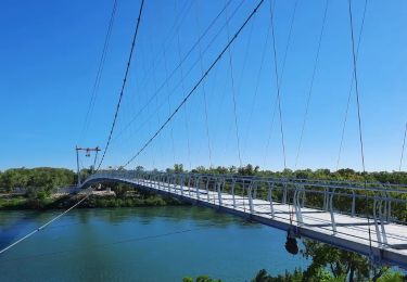
une jolie balade
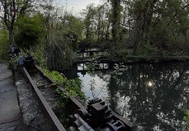
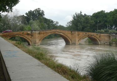
EN revenant on passe par les bords de la sorgue , l'ancienne gare
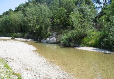
et pour finir le parcours de santé
Ort
Land:
France
Region :
Provence-Alpes-Côte d'Azur
Abteilung/Provinz :
Vaucluse
Kommune :
Entraigues-sur-la-Sorgue
Standort:
Unknown
Gehen Sie:(Dec)
Gehen Sie:(UTM)
654554 ; 4874055 (31T) N.
Kommentare
Touren in der Umgebung
![Tour Wandern Sorgues - La Montagnette Sorgues - Photo](https://media.geolcdn.com/t/375/260/ext.jpg?maxdim=2&url=https%3A%2F%2Fstatic1.geolcdn.com%2Fsiteimages%2Fupload%2Ffiles%2F1553511878bg_sport_marche.png)
![Wandern Wandern](https://static1.geolcdn.com/sitytour/trail-icons/101.png)
La Montagnette Sorgues
Wandern
Medium
(1)
Sorgues,
Provence-Alpes-Côte d'Azur,
Vaucluse,
France
![](/images/other/stat-length.png)
6,3 km | 7,7 km-effort
2h 18min
![](https://static1.geolcdn.com/siteimages/upload/files/16400158638029165_repeat_loop_refresh_sync_direction_icon.png)
Ja
![Tour Wandern Entraigues-sur-la-Sorgue - Balade à Entraigues sur la sorgue - Photo](https://media.geolcdn.com/t/375/260/ext.jpg?maxdim=2&url=https%3A%2F%2Fstatic1.geolcdn.com%2Fsiteimages%2Fupload%2Ffiles%2F1553511878bg_sport_marche.png)
![Wandern Wandern](https://static1.geolcdn.com/sitytour/trail-icons/101.png)
Balade à Entraigues sur la sorgue
Wandern
Einfach
(1)
Entraigues-sur-la-Sorgue,
Provence-Alpes-Côte d'Azur,
Vaucluse,
France
![](/images/other/stat-length.png)
8,6 km | 9,9 km-effort
2h 12min
![](https://static1.geolcdn.com/siteimages/upload/files/16400158638029165_repeat_loop_refresh_sync_direction_icon.png)
Ja
![Tour Wandern Entraigues-sur-la-Sorgue - BALLADE AUTOUR D ENTRAIGUES SUR LA SORGUE , ECLUSES ET CASCADE - Photo](https://media.geolcdn.com/t/375/260/ee798285-fef1-41c7-b8ad-acf2df985316.jpg&format=jpg&maxdim=2)
![Wandern Wandern](https://static1.geolcdn.com/sitytour/trail-icons/101.png)
BALLADE AUTOUR D ENTRAIGUES SUR LA SORGUE , ECLUSES ET CASCADE
Wandern
Einfach
Entraigues-sur-la-Sorgue,
Provence-Alpes-Côte d'Azur,
Vaucluse,
France
![](/images/other/stat-length.png)
6,8 km | 7,2 km-effort
1h 37min
![](https://static1.geolcdn.com/siteimages/upload/files/16400158638029165_repeat_loop_refresh_sync_direction_icon.png)
Ja
![Tour Wandern Sorgues - SityTrail - Sorgues Hymalayenne - Photo](https://media.geolcdn.com/t/375/260/4f2a5ca5-0160-4735-ace4-9024c1196832.jpeg&format=jpg&maxdim=2)
![Wandern Wandern](https://static1.geolcdn.com/sitytour/trail-icons/101.png)
SityTrail - Sorgues Hymalayenne
Wandern
Sorgues,
Provence-Alpes-Côte d'Azur,
Vaucluse,
France
![](/images/other/stat-length.png)
15,4 km | 17 km-effort
4h 30min
![](https://static1.geolcdn.com/siteimages/upload/files/16400158638029165_repeat_loop_refresh_sync_direction_icon.png)
Ja
![Tour Wandern Entraigues-sur-la-Sorgue - entraigues 84 berges des sorgues - Photo](https://media.geolcdn.com/t/375/260/e4dd64c0-cdb7-468a-954a-2dc0f868a48a.jpg&format=jpg&maxdim=2)
![Wandern Wandern](https://static1.geolcdn.com/sitytour/trail-icons/101.png)
entraigues 84 berges des sorgues
Wandern
Sehr leicht
Entraigues-sur-la-Sorgue,
Provence-Alpes-Côte d'Azur,
Vaucluse,
France
![](/images/other/stat-length.png)
8,8 km | 9,5 km-effort
2h 45min
![](https://static1.geolcdn.com/siteimages/upload/files/16400158638029165_repeat_loop_refresh_sync_direction_icon.png)
Ja
![Tour Wandern Vedène - Vedène - Photo](https://media.geolcdn.com/t/375/260/b7ef3f78-0f3b-42be-9fac-6449679eebf5.jpg&format=jpg&maxdim=2)
![Wandern Wandern](https://static1.geolcdn.com/sitytour/trail-icons/101.png)
Vedène
Wandern
Vedène,
Provence-Alpes-Côte d'Azur,
Vaucluse,
France
![](/images/other/stat-length.png)
4,6 km | 4,8 km-effort
1h 11min
![](https://static1.geolcdn.com/siteimages/upload/files/16400158638029165_repeat_loop_refresh_sync_direction_icon.png)
Ja
![Tour Fahrrad Bédarrides - Circuit Vélo - Promenade sur les rives de l'Ouvèze Variante - Bédarrides - Photo](https://media.geolcdn.com/t/375/260/ext.jpg?maxdim=2&url=https%3A%2F%2Fservices.sitytrail.com%2FGeolivesWS%2FDownloadMedia.ashx%3FTrailID%3D111849%26Media%3D8622_1.jpg)
![Fahrrad Fahrrad](https://static1.geolcdn.com/sitytour/trail-icons/200.png)
Circuit Vélo - Promenade sur les rives de l'Ouvèze Variante - Bédarrides
Fahrrad
Medium
Bédarrides,
Provence-Alpes-Côte d'Azur,
Vaucluse,
France
![](/images/other/stat-length.png)
24 km | 26 km-effort
2h 0min
![](https://static1.geolcdn.com/siteimages/upload/files/16400158638029165_repeat_loop_refresh_sync_direction_icon.png)
Ja
![Tour Fahrrad Bédarrides - Circuit Vélo - Promenade sur les rives de l'Ouvèze - Bédarrides - Photo](https://media.geolcdn.com/t/375/260/ext.jpg?maxdim=2&url=https%3A%2F%2Fservices.sitytrail.com%2FGeolivesWS%2FDownloadMedia.ashx%3FTrailID%3D111848%26Media%3D8621_1.jpg)
![Fahrrad Fahrrad](https://static1.geolcdn.com/sitytour/trail-icons/200.png)
Circuit Vélo - Promenade sur les rives de l'Ouvèze - Bédarrides
Fahrrad
Medium
Bédarrides,
Provence-Alpes-Côte d'Azur,
Vaucluse,
France
![](/images/other/stat-length.png)
18,7 km | 20 km-effort
1h 30min
![](https://static1.geolcdn.com/siteimages/upload/files/16400158638029165_repeat_loop_refresh_sync_direction_icon.png)
Ja
![Tour sport Vedène - Vedène - Photo](https://media.geolcdn.com/t/375/260/ext.jpg?maxdim=2&url=https%3A%2F%2Fsecurestorage.geolives.com%2Fsitytour%2Ftrail-bg%2Fdefault.jpg)
Vedène
sport
Sehr leicht
Vedène,
Provence-Alpes-Côte d'Azur,
Vaucluse,
France
![](/images/other/stat-length.png)
5 km | 6 km-effort
Unbekannt
![](https://static1.geolcdn.com/siteimages/upload/files/16400158638029165_repeat_loop_refresh_sync_direction_icon.png)
Ja