st Jean dès baisants SityTrail > Touren > Outdoor > France > Normandie > Manche > Saint-Jean-d'Elle SityTrail > Touren > Outdoor > France > Normandie > Manche > Saint-Jean-d'Elle st Jean dès baisants philippol Benutzer 3D © OpenStreetMap contributors Länge 9,2 km Maximale Höhe 208 m Positive Höhendifferenz 166 m Km-Effort 11,4 km Min. Höhe 67 m Negative Höhendifferenz 167 m Boucle Ja Erstellungsdatum : 2019-03-30 12:21:54.873 Letzte Änderung : 2019-03-30 14:32:45.647 (0 Nachricht) Wandern 2h10 Schwierigkeit : Sehr leicht Kostenlosegpshiking-Anwendung SityTrail IGN / Geografische Institute SityTrail World Die Welt öffnet sich für Sie Über SityTrail 
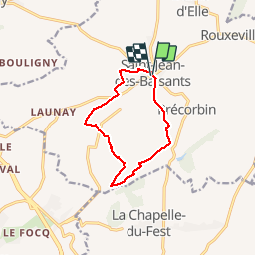
Tour Wandern von 9,2 km verfügbar auf Normandie, Manche, Saint-Jean-d'Elle. Diese Tour wird von philippol vorgeschlagen. Legenden | Mehr Details (PDF) Höhenprofil Legenden > 15% 15% - 10% 10% - 5% Wohnung 5% - 10% 10% - 15% 15% - 30% > 30% Ort Land: France Region : Normandie Abteilung/Provinz : Manche Kommune : Saint-Jean-d'Elle Standort: Saint-Jean-des-Baisants Gehen Sie:(Dec) 49.09349860869859 / -0.9731091652925102 Gehen Sie:(UTM) 647970 ; 5439828 (30U) N. Kommentare Bitte melden Sie sich an, um einen Kommentar oder eine Bewertung zu hinterlassen Touren in der Umgebung tracegps Dans les pas des pèlerins - Saint Jean des Baisants Wandern Medium Saint-Jean-d'Elle, Normandie, Manche, France 15,3 km | 19,4 km-effort 4h 0min Ja MarlèneK Saint Amand 27 février 2021 Wandern Sehr leicht Saint-Amand-Villages, Normandie, Manche, France 8,7 km | 10,5 km-effort 2h 2min Ja Lucquiaud 2017-05-25 Condé sur Vire Mountainbike Medium Condé-sur-Vire, Normandie, Manche, France 60 km | 72 km-effort 4h 37min Ja Wr250R 2015-04-26 09h54m20 Wandern Medium La Barre-de-Semilly, Normandie, Manche, France 61 km | 76 km-effort Unbekannt Nein