![](/images/other/stat-length.png)
![Tour Rennrad Calvià - Jour 3 - 120km - Photo](https://media.geolcdn.com/t/1900/400/ext.pjpeg?maxdim=2&url=https%3A%2F%2Fstatic1.geolcdn.com%2Fsiteimages%2Fupload%2Ffiles%2F1524743154velo.jpg)
Jour 3 - 120km
bobby1
Benutzer
![Länge](/images/other/stat-length.png)
Länge
118 km
![Maximale Höhe](https://static1.geolcdn.com/siteimages/upload/files/1508320355ic_sort_altitude_max_24dp.png)
Maximale Höhe
566 m
![Positive Höhendifferenz](https://static1.geolcdn.com/siteimages/upload/files/1508320355ic_sort_den_pos_24dp.png)
Positive Höhendifferenz
1983 m
![Km-Effort](/images/other/stat-length.png)
Km-Effort
145 km
![Min. Höhe](https://static1.geolcdn.com/siteimages/upload/files/1508320355ic_sort_altitude_min_24dp.png)
Min. Höhe
7 m
![Negative Höhendifferenz](https://static1.geolcdn.com/siteimages/upload/files/1508320355ic_sort_den_neg_24dp.png)
Negative Höhendifferenz
1983 m
![Boucle](https://static1.geolcdn.com/siteimages/upload/files/16400158638029165_repeat_loop_refresh_sync_direction_icon.png)
Boucle
Ja
Erstellungsdatum :
2019-03-25 21:27:00.044
Letzte Änderung :
2019-03-25 21:29:36.884
![Rennrad](https://static1.geolcdn.com/sitytour/trail-icons/201.png)
8h22
Schwierigkeit : Sehr schwierig
![Scannen Sie diesen QR-Code, um die Tour in der SityTrail-Anwendung zu öffnen](https://capi.geolives.com/qq0zvz2zws4bq2lad0pu/sitytour/trails/2052620/qr.png?size=200)
Kostenlosegpshiking-Anwendung
Über SityTrail
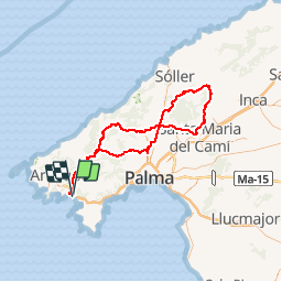
Tour Rennrad von 118 km verfügbar auf Balearische Inseln, Unbekannt, Calvià. Diese Tour wird von bobby1 vorgeschlagen.
Beschreibung
Peguera - Es Capdella - Galilea - Puigpunynet - 1041 - Establiment - rte 2031 - 2020 - Alaro - 2100 - Orient - Bunyola - Palmanyola - Esgleieta - Esporles - Puigpunyent - Galilea - Es Capdella - Peguera
Ort
Land:
Spain
Region :
Balearische Inseln
Abteilung/Provinz :
Unbekannt
Kommune :
Calvià
Standort:
Unknown
Gehen Sie:(Dec)
Gehen Sie:(UTM)
453535 ; 4376160 (31S) N.
Kommentare
Touren in der Umgebung
![Tour Zu Fuß Calvià - ES-This has not official name. It seems it has german unofficial name. Please, note that the hiking routes have no name if not appear in official sources (Consell de Mallorca, Comunitat Autònoma de les Illes Balears, Townhall publications, etc) - Photo](https://media.geolcdn.com/t/375/260/e790b3da-512c-4682-a0e9-5527d7d0b775.jpeg&format=jpg&maxdim=2)
![Zu Fuß Zu Fuß](https://static1.geolcdn.com/sitytour/trail-icons/100.png)
ES-This has not official name. It seems it has german unofficial name. Please...
Zu Fuß
Einfach
Calvià,
Balearische Inseln,
Unbekannt,
Spain
![](/images/other/stat-length.png)
3,7 km | 4,7 km-effort
1h 4min
![](https://static1.geolcdn.com/siteimages/upload/files/16400158638029165_repeat_loop_refresh_sync_direction_icon.png)
Nein
![Tour sport Calvià - Cap d’andritxol - Photo](https://media.geolcdn.com/t/375/260/26ada991-bf8c-4338-bbf8-83ce755ec14e.jpg&format=jpg&maxdim=2)
Cap d’andritxol
sport
Sehr leicht
Calvià,
Balearische Inseln,
Unbekannt,
Spain
![](/images/other/stat-length.png)
7,1 km | 10,1 km-effort
Unbekannt
![](https://static1.geolcdn.com/siteimages/upload/files/16400158638029165_repeat_loop_refresh_sync_direction_icon.png)
Ja
![Tour Zu Fuß Calvià - Nachtigallental - Photo](https://media.geolcdn.com/t/375/260/ext.jpg?maxdim=2&url=https%3A%2F%2Fstatic1.geolcdn.com%2Fsiteimages%2Fupload%2Ffiles%2F1545311037marcheuse_200dpi.jpg)
![Zu Fuß Zu Fuß](https://static1.geolcdn.com/sitytour/trail-icons/100.png)
Nachtigallental
Zu Fuß
Einfach
Calvià,
Balearische Inseln,
Unbekannt,
Spain
![](/images/other/stat-length.png)
5,6 km | 7,2 km-effort
1h 37min
![](https://static1.geolcdn.com/siteimages/upload/files/16400158638029165_repeat_loop_refresh_sync_direction_icon.png)
Nein
![Tour Rennrad Calvià - Jour 2 - 98km - Photo](https://media.geolcdn.com/t/375/260/ext.jpg?maxdim=2&url=https%3A%2F%2Fstatic1.geolcdn.com%2Fsiteimages%2Fupload%2Ffiles%2F1524743154velo.jpg)
![Rennrad Rennrad](https://static1.geolcdn.com/sitytour/trail-icons/201.png)
Jour 2 - 98km
Rennrad
Sehr schwierig
Calvià,
Balearische Inseln,
Unbekannt,
Spain
![](/images/other/stat-length.png)
98 km | 128 km-effort
7h 18min
![](https://static1.geolcdn.com/siteimages/upload/files/16400158638029165_repeat_loop_refresh_sync_direction_icon.png)
Ja
![Tour Wandern Calvià - Mallorca-Cap Andritxol 18-10-2017 - Photo](https://media.geolcdn.com/t/375/260/ext.jpg?maxdim=2&url=https%3A%2F%2Fstatic1.geolcdn.com%2Fsiteimages%2Fupload%2Ffiles%2F1553511878bg_sport_marche.png)
![Wandern Wandern](https://static1.geolcdn.com/sitytour/trail-icons/101.png)
Mallorca-Cap Andritxol 18-10-2017
Wandern
Einfach
Calvià,
Balearische Inseln,
Unbekannt,
Spain
![](/images/other/stat-length.png)
8,7 km | 12,2 km-effort
2h 32min
![](https://static1.geolcdn.com/siteimages/upload/files/16400158638029165_repeat_loop_refresh_sync_direction_icon.png)
Ja
![Tour Wandern Calvià - Mallorca-Sa Bruta 18-10-2017 - Photo](https://media.geolcdn.com/t/375/260/ext.jpg?maxdim=2&url=https%3A%2F%2Fstatic1.geolcdn.com%2Fsiteimages%2Fupload%2Ffiles%2F1553511878bg_sport_marche.png)
![Wandern Wandern](https://static1.geolcdn.com/sitytour/trail-icons/101.png)
Mallorca-Sa Bruta 18-10-2017
Wandern
Einfach
Calvià,
Balearische Inseln,
Unbekannt,
Spain
![](/images/other/stat-length.png)
6,5 km | 10 km-effort
2h 13min
![](https://static1.geolcdn.com/siteimages/upload/files/16400158638029165_repeat_loop_refresh_sync_direction_icon.png)
Ja
![Tour Fahrrad Andratx - andtrax_to_pollenca_8_cols_154k_3000m - Photo](https://media.geolcdn.com/t/375/260/ext.jpg?maxdim=2&url=https%3A%2F%2Fstatic1.geolcdn.com%2Fsiteimages%2Fupload%2Ffiles%2F1524743154velo.jpg)
![Fahrrad Fahrrad](https://static1.geolcdn.com/sitytour/trail-icons/200.png)
andtrax_to_pollenca_8_cols_154k_3000m
Fahrrad
Sehr schwierig
Andratx,
Balearische Inseln,
Unbekannt,
Spain
![](/images/other/stat-length.png)
154 km | 197 km-effort
Unbekannt
![](https://static1.geolcdn.com/siteimages/upload/files/16400158638029165_repeat_loop_refresh_sync_direction_icon.png)
Nein
![Tour Fahrrad Andratx - andratx_to_pollenca_ma10_116k_2500m - Photo](https://media.geolcdn.com/t/375/260/ext.jpg?maxdim=2&url=https%3A%2F%2Fstatic1.geolcdn.com%2Fsiteimages%2Fupload%2Ffiles%2F1524743154velo.jpg)
![Fahrrad Fahrrad](https://static1.geolcdn.com/sitytour/trail-icons/200.png)
andratx_to_pollenca_ma10_116k_2500m
Fahrrad
Schwierig
Andratx,
Balearische Inseln,
Unbekannt,
Spain
![](/images/other/stat-length.png)
116 km | 156 km-effort
Unbekannt
![](https://static1.geolcdn.com/siteimages/upload/files/16400158638029165_repeat_loop_refresh_sync_direction_icon.png)
Nein
![Tour Fahrrad Andratx - andtrax_to_pollenca_139k_2600m - Photo](https://media.geolcdn.com/t/375/260/ext.jpg?maxdim=2&url=https%3A%2F%2Fstatic1.geolcdn.com%2Fsiteimages%2Fupload%2Ffiles%2F1524743154velo.jpg)
![Fahrrad Fahrrad](https://static1.geolcdn.com/sitytour/trail-icons/200.png)
andtrax_to_pollenca_139k_2600m
Fahrrad
Schwierig
Andratx,
Balearische Inseln,
Unbekannt,
Spain
![](/images/other/stat-length.png)
139 km | 177 km-effort
Unbekannt
![](https://static1.geolcdn.com/siteimages/upload/files/16400158638029165_repeat_loop_refresh_sync_direction_icon.png)
Nein