![](/images/other/stat-length.png)
![Tour Wandern Moissac-Bellevue - Moissac-Bellevue - Photo](https://media.geolcdn.com/t/1900/400/ext.pjpeg?maxdim=2&url=https%3A%2F%2Fstatic1.geolcdn.com%2Fsiteimages%2Fupload%2Ffiles%2F1553511878bg_sport_marche.png)
Moissac-Bellevue
Greg813
Benutzer
![Länge](/images/other/stat-length.png)
Länge
12,4 km
![Maximale Höhe](https://static1.geolcdn.com/siteimages/upload/files/1508320355ic_sort_altitude_max_24dp.png)
Maximale Höhe
806 m
![Positive Höhendifferenz](https://static1.geolcdn.com/siteimages/upload/files/1508320355ic_sort_den_pos_24dp.png)
Positive Höhendifferenz
268 m
![Km-Effort](/images/other/stat-length.png)
Km-Effort
15,9 km
![Min. Höhe](https://static1.geolcdn.com/siteimages/upload/files/1508320355ic_sort_altitude_min_24dp.png)
Min. Höhe
586 m
![Negative Höhendifferenz](https://static1.geolcdn.com/siteimages/upload/files/1508320355ic_sort_den_neg_24dp.png)
Negative Höhendifferenz
267 m
![Boucle](https://static1.geolcdn.com/siteimages/upload/files/16400158638029165_repeat_loop_refresh_sync_direction_icon.png)
Boucle
Ja
Erstellungsdatum :
2019-03-23 13:07:33.772
Letzte Änderung :
2019-03-24 06:52:09.009
![Wandern](https://static1.geolcdn.com/sitytour/trail-icons/101.png)
2h59
Schwierigkeit : Einfach
![Scannen Sie diesen QR-Code, um die Tour in der SityTrail-Anwendung zu öffnen](https://capi.geolives.com/qq0zvz2zws4bq2lad0pu/sitytour/trails/2051196/qr.png?size=200)
Kostenlosegpshiking-Anwendung
Über SityTrail
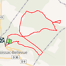
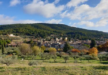
Tour Wandern von 12,4 km verfügbar auf Provence-Alpes-Côte d'Azur, Var, Moissac-Bellevue. Diese Tour wird von Greg813 vorgeschlagen.
Beschreibung
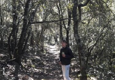
Randonnée très accessible sur les hauteurs de Moissac, parfois ombragée.
Possibilité de raccourcir à 5km en ne faisant que la première boucle.
Ort
Land:
France
Region :
Provence-Alpes-Côte d'Azur
Abteilung/Provinz :
Var
Kommune :
Moissac-Bellevue
Standort:
Unknown
Gehen Sie:(Dec)
Gehen Sie:(UTM)
271179 ; 4837559 (32T) N.
Kommentare
Touren in der Umgebung
![Tour Laufen Moissac-Bellevue - TRAIL DE MOISSAC 2016 10KM +330 - Photo](https://media.geolcdn.com/t/375/260/ext.jpg?maxdim=2&url=https%3A%2F%2Fservices.sitytrail.com%2FGeolivesWS%2FDownloadMedia.ashx%3FTrailID%3D540393%26Media%3Dfix__20160319134649.jpg)
![Laufen Laufen](https://static1.geolcdn.com/sitytour/trail-icons/103.png)
TRAIL DE MOISSAC 2016 10KM +330
Laufen
Schwierig
(1)
Moissac-Bellevue,
Provence-Alpes-Côte d'Azur,
Var,
France
![](/images/other/stat-length.png)
9,7 km | 14,2 km-effort
1h 35min
![](https://static1.geolcdn.com/siteimages/upload/files/16400158638029165_repeat_loop_refresh_sync_direction_icon.png)
Ja
![Tour Wandern Aups - Aups - Photo](https://media.geolcdn.com/t/375/260/fd86a7ef-4f3e-4db0-8d1f-50f58d38a091.jpg&format=jpg&maxdim=2)
![Wandern Wandern](https://static1.geolcdn.com/sitytour/trail-icons/101.png)
Aups
Wandern
Einfach
Aups,
Provence-Alpes-Côte d'Azur,
Var,
France
![](/images/other/stat-length.png)
23 km | 27 km-effort
6h 4min
![](https://static1.geolcdn.com/siteimages/upload/files/16400158638029165_repeat_loop_refresh_sync_direction_icon.png)
Nein
![Tour Wandern Moissac-Bellevue - 20200930 moissac sud Pellenc - Photo](https://media.geolcdn.com/t/375/260/e8a3c548-c090-4849-8869-0f59c08f430b.jpg&format=jpg&maxdim=2)
![Wandern Wandern](https://static1.geolcdn.com/sitytour/trail-icons/101.png)
20200930 moissac sud Pellenc
Wandern
Medium
Moissac-Bellevue,
Provence-Alpes-Côte d'Azur,
Var,
France
![](/images/other/stat-length.png)
15,1 km | 18,7 km-effort
6h 7min
![](https://static1.geolcdn.com/siteimages/upload/files/16400158638029165_repeat_loop_refresh_sync_direction_icon.png)
Ja
![Tour Mountainbike Moissac-Bellevue - Foret de Poulenc aups moissac - Photo](https://media.geolcdn.com/t/375/260/c0a83bd5-e945-42cd-94b1-afeddb8d22b8.jpg&format=jpg&maxdim=2)
![Mountainbike Mountainbike](https://static1.geolcdn.com/sitytour/trail-icons/202.png)
Foret de Poulenc aups moissac
Mountainbike
Einfach
Moissac-Bellevue,
Provence-Alpes-Côte d'Azur,
Var,
France
![](/images/other/stat-length.png)
21 km | 25 km-effort
2h 14min
![](https://static1.geolcdn.com/siteimages/upload/files/16400158638029165_repeat_loop_refresh_sync_direction_icon.png)
Ja
![Tour Wandern Régusse - Regusse 10.06.2019 - Photo](https://media.geolcdn.com/t/375/260/d4c5de81-e839-46ca-85a7-85b7c5e731cb.jpg&format=jpg&maxdim=2)
![Wandern Wandern](https://static1.geolcdn.com/sitytour/trail-icons/101.png)
Regusse 10.06.2019
Wandern
Régusse,
Provence-Alpes-Côte d'Azur,
Var,
France
![](/images/other/stat-length.png)
13,7 km | 16,3 km-effort
3h 37min
![](https://static1.geolcdn.com/siteimages/upload/files/16400158638029165_repeat_loop_refresh_sync_direction_icon.png)
Ja
![Tour Wandern Moissac-Bellevue - Moissac Bellevue La Colle 2 - Photo](https://media.geolcdn.com/t/375/260/ext.jpg?maxdim=2&url=https%3A%2F%2Fservices.sitytrail.com%2FGeolivesWS%2FDownloadMedia.ashx%3FTrailID%3D919321%26Media%3Dfix__20180307094329.jpg)
![Wandern Wandern](https://static1.geolcdn.com/sitytour/trail-icons/101.png)
Moissac Bellevue La Colle 2
Wandern
Sehr leicht
Moissac-Bellevue,
Provence-Alpes-Côte d'Azur,
Var,
France
![](/images/other/stat-length.png)
17,8 km | 23 km-effort
5h 54min
![](https://static1.geolcdn.com/siteimages/upload/files/16400158638029165_repeat_loop_refresh_sync_direction_icon.png)
Ja
![Tour Wandern Moissac-Bellevue - MOISSAC BAUDUEN 13KM - Photo](https://media.geolcdn.com/t/375/260/ext.jpg?maxdim=2&url=https%3A%2F%2Fstatic1.geolcdn.com%2Fsiteimages%2Fupload%2Ffiles%2F1553511878bg_sport_marche.png)
![Wandern Wandern](https://static1.geolcdn.com/sitytour/trail-icons/101.png)
MOISSAC BAUDUEN 13KM
Wandern
Medium
(1)
Moissac-Bellevue,
Provence-Alpes-Côte d'Azur,
Var,
France
![](/images/other/stat-length.png)
12,9 km | 16,4 km-effort
6h 0min
![](https://static1.geolcdn.com/siteimages/upload/files/16400158638029165_repeat_loop_refresh_sync_direction_icon.png)
Nein
![Tour Wandern Régusse - La Chapelle St Jean, Villeneuve, les Moulins-REGUSSE - Photo](https://media.geolcdn.com/t/375/260/89714cf9-d080-495a-8a68-d88ae96b4468.jpg&format=jpg&maxdim=2)
![Wandern Wandern](https://static1.geolcdn.com/sitytour/trail-icons/101.png)
La Chapelle St Jean, Villeneuve, les Moulins-REGUSSE
Wandern
Medium
Régusse,
Provence-Alpes-Côte d'Azur,
Var,
France
![](/images/other/stat-length.png)
11,2 km | 13,1 km-effort
2h 59min
![](https://static1.geolcdn.com/siteimages/upload/files/16400158638029165_repeat_loop_refresh_sync_direction_icon.png)
Ja
![Tour Pfad Moissac-Bellevue - Moissac-Bellevue Course à pied - Photo](https://media.geolcdn.com/t/375/260/3211808f-db24-428c-9391-d8b78875ed24.jpg&format=jpg&maxdim=2)
![Pfad Pfad](https://static1.geolcdn.com/sitytour/trail-icons/104.png)
Moissac-Bellevue Course à pied
Pfad
Einfach
Moissac-Bellevue,
Provence-Alpes-Côte d'Azur,
Var,
France
![](/images/other/stat-length.png)
11,5 km | 16,9 km-effort
1h 30min
![](https://static1.geolcdn.com/siteimages/upload/files/16400158638029165_repeat_loop_refresh_sync_direction_icon.png)
Ja