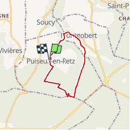
![](/images/other/stat-length.png)
![Tour Wandern Puiseux-en-Retz - Le ru de Retz - Photo](https://media.geolcdn.com/t/1900/400/ext.pjpeg?maxdim=2&url=https%3A%2F%2Fservices.sitytrail.com%2FGeolivesWS%2FDownloadMedia.ashx%3FTrailID%3D202840%26Media%3D045965e1-e01d-435d-b2dd-4dc5c5f6041a.jpg)
Le ru de Retz
Rando Famili
Randonnées de RandoFamili
![Länge](/images/other/stat-length.png)
![Maximale Höhe](https://static1.geolcdn.com/siteimages/upload/files/1508320355ic_sort_altitude_max_24dp.png)
![Positive Höhendifferenz](https://static1.geolcdn.com/siteimages/upload/files/1508320355ic_sort_den_pos_24dp.png)
![Km-Effort](/images/other/stat-length.png)
![Min. Höhe](https://static1.geolcdn.com/siteimages/upload/files/1508320355ic_sort_altitude_min_24dp.png)
![Negative Höhendifferenz](https://static1.geolcdn.com/siteimages/upload/files/1508320355ic_sort_den_neg_24dp.png)
![Boucle](https://static1.geolcdn.com/siteimages/upload/files/16400158638029165_repeat_loop_refresh_sync_direction_icon.png)
![Wandern](https://static1.geolcdn.com/sitytour/trail-icons/101.png)
--
Schwierigkeit : Unbekannt
![Scannen Sie diesen QR-Code, um die Tour in der SityTrail-Anwendung zu öffnen](https://capi.geolives.com/qq0zvz2zws4bq2lad0pu/sitytour/trails/202840/qr.png?size=200)
Kostenlosegpshiking-Anwendung
Über SityTrail
Tour Wandern von 9,1 km verfügbar auf Nordfrankreich, Aisne, Puiseux-en-Retz. Diese Tour wird von Rando Famili vorgeschlagen.
Beschreibung
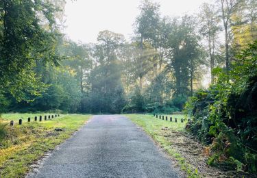
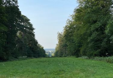
Depuis le village fleuri de Puisieux, de pinède en hêtraie et en peupleraie, ce circuit entre forêts et vallons mène au monument Mangin, hommage à la contre-offensive décisive de 1918, puis à Montgobert, où le musée du Bois présente dans le château une impressionnante collection d'outils agricoles et forestiers.
Ort
Kommentare
Touren in der Umgebung
![Tour Wandern Corcy - FLEURY .AISNE - Photo](https://media.geolcdn.com/t/375/260/761ff574-2cac-48f6-adc9-2cc5319599a5.jpg&format=jpg&maxdim=2)
![Wandern Wandern](https://static1.geolcdn.com/sitytour/trail-icons/101.png)
Wandern
![](/images/other/stat-length.png)
![](https://static1.geolcdn.com/siteimages/upload/files/16400158638029165_repeat_loop_refresh_sync_direction_icon.png)
![Tour Wandern Fleury - en Forêt de Retz_92_05_2022_Rond d'Orléans_Chapeau des Cordeliers_la Laie des étangs de Longpont - Photo](https://media.geolcdn.com/t/375/260/906f40d3-9cf9-4a7a-b2a8-7fc1acf87fb9.jpg&format=jpg&maxdim=2)
![Wandern Wandern](https://static1.geolcdn.com/sitytour/trail-icons/101.png)
Wandern
![](/images/other/stat-length.png)
![](https://static1.geolcdn.com/siteimages/upload/files/16400158638029165_repeat_loop_refresh_sync_direction_icon.png)
![Tour Wandern Corcy - en forêt de Retz_91_04_2022_la Laie de la Belle Epine - Photo](https://media.geolcdn.com/t/375/260/28921992-4eb0-4c37-93fe-d10d0fd6e5c8.jpg&format=jpg&maxdim=2)
![Wandern Wandern](https://static1.geolcdn.com/sitytour/trail-icons/101.png)
Wandern
![](/images/other/stat-length.png)
![](https://static1.geolcdn.com/siteimages/upload/files/16400158638029165_repeat_loop_refresh_sync_direction_icon.png)
![Tour Zu Fuß Puiseux-en-Retz - Route du Faîte - Photo](https://media.geolcdn.com/t/375/260/ed0a74b8-9801-4168-82e4-02efd0513983.jpeg&format=jpg&maxdim=2)
![Zu Fuß Zu Fuß](https://static1.geolcdn.com/sitytour/trail-icons/100.png)
Zu Fuß
![](/images/other/stat-length.png)
![](https://static1.geolcdn.com/siteimages/upload/files/16400158638029165_repeat_loop_refresh_sync_direction_icon.png)
![Wandern Wandern](https://static1.geolcdn.com/sitytour/trail-icons/101.png)
Wandern
![](/images/other/stat-length.png)
![](https://static1.geolcdn.com/siteimages/upload/files/16400158638029165_repeat_loop_refresh_sync_direction_icon.png)
![Wandern Wandern](https://static1.geolcdn.com/sitytour/trail-icons/101.png)
Wandern
![](/images/other/stat-length.png)
![](https://static1.geolcdn.com/siteimages/upload/files/16400158638029165_repeat_loop_refresh_sync_direction_icon.png)
![Tour Wandern Villers-Cotterêts - Domaine de Coyolles - Photo](https://media.geolcdn.com/t/375/260/3c6e9d1b-7123-437c-8691-246218d3d596.jpg&format=jpg&maxdim=2)
![Wandern Wandern](https://static1.geolcdn.com/sitytour/trail-icons/101.png)
Wandern
![](/images/other/stat-length.png)
![](https://static1.geolcdn.com/siteimages/upload/files/16400158638029165_repeat_loop_refresh_sync_direction_icon.png)
![Tour Wandern Vivières - en Forêt de Retz_88_autour du Regard Saint-Hubert et du Rond de la Reine - Photo](https://media.geolcdn.com/t/375/260/084779ef-6027-4c87-8964-afb49c5434d1.jpg&format=jpg&maxdim=2)
![Wandern Wandern](https://static1.geolcdn.com/sitytour/trail-icons/101.png)
Wandern
![](/images/other/stat-length.png)
![](https://static1.geolcdn.com/siteimages/upload/files/16400158638029165_repeat_loop_refresh_sync_direction_icon.png)
![Wandern Wandern](https://static1.geolcdn.com/sitytour/trail-icons/101.png)
Wandern
![](/images/other/stat-length.png)
![](https://static1.geolcdn.com/siteimages/upload/files/16400158638029165_repeat_loop_refresh_sync_direction_icon.png)