![](/images/other/stat-length.png)
![Tour Andere Aktivitäten Sisikon - Sisikon - Brunnen - Photo](https://media.geolcdn.com/t/1900/400/ext.pjpeg?maxdim=2&url=https%3A%2F%2Fstatic1.geolcdn.com%2Fsiteimages%2Fupload%2Ffiles%2F1545311037marcheuse_200dpi.jpg)
Sisikon - Brunnen
jschna
Benutzer
![Länge](/images/other/stat-length.png)
![Maximale Höhe](https://static1.geolcdn.com/siteimages/upload/files/1508320355ic_sort_altitude_max_24dp.png)
![Positive Höhendifferenz](https://static1.geolcdn.com/siteimages/upload/files/1508320355ic_sort_den_pos_24dp.png)
![Km-Effort](/images/other/stat-length.png)
![Min. Höhe](https://static1.geolcdn.com/siteimages/upload/files/1508320355ic_sort_altitude_min_24dp.png)
![Negative Höhendifferenz](https://static1.geolcdn.com/siteimages/upload/files/1508320355ic_sort_den_neg_24dp.png)
![Boucle](https://static1.geolcdn.com/siteimages/upload/files/16400158638029165_repeat_loop_refresh_sync_direction_icon.png)
![Andere Aktivitäten](https://static1.geolcdn.com/sitytour/trail-icons/900.png)
--
Schwierigkeit : Unbekannt
![Scannen Sie diesen QR-Code, um die Tour in der SityTrail-Anwendung zu öffnen](https://capi.geolives.com/qq0zvz2zws4bq2lad0pu/sitytour/trails/20258/qr.png?size=200)
Kostenlosegpshiking-Anwendung
Über SityTrail
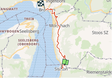
Tour Andere Aktivitäten von 10,3 km verfügbar auf Uri, Unbekannt, Sisikon. Diese Tour wird von jschna vorgeschlagen.
Beschreibung
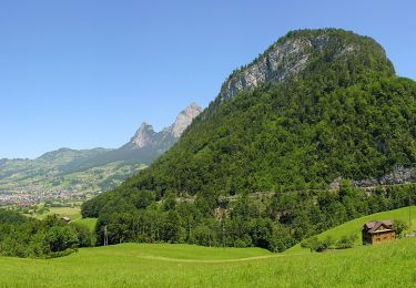
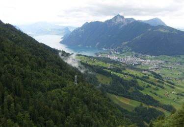
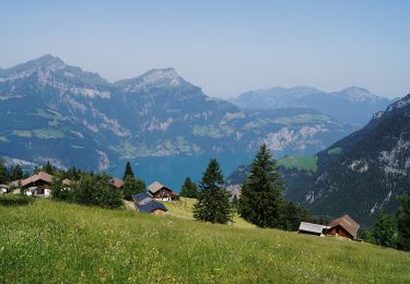
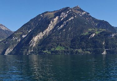
Vom Bahnhof Sisikon steigt der Weg für ca. 45 Min. ziemlich steil an, dann gehts etwas gemächlicher. Stets eine wunderschöne Aussicht vor Augen, muss man von Zeit zu Zeit Pause machen und diese Rundsicht geniessen. Verpflegen kann man sich in Morschach, oder aber in Brunnen, wo das Angebot noch grösser ist. (In der Marschzeit sind auch ca. 40 Min. Pausen inbegriffen.)
Ort
Kommentare
Touren in der Umgebung
![Tour Zu Fuß Morschach - Stoos - Klingenstock - Photo](https://media.geolcdn.com/t/375/260/7f4d7922-1b45-4336-bb8c-cff5bc34903a.jpeg&format=jpg&maxdim=2)
![Zu Fuß Zu Fuß](https://static1.geolcdn.com/sitytour/trail-icons/100.png)
Zu Fuß
![](/images/other/stat-length.png)
![](https://static1.geolcdn.com/siteimages/upload/files/16400158638029165_repeat_loop_refresh_sync_direction_icon.png)
![Tour Zu Fuß Morschach - Morschach - Stoss - Photo](https://media.geolcdn.com/t/375/260/173b4dbb-56ad-42ac-9fee-76e2b9dfa97c.jpeg&format=jpg&maxdim=2)
![Zu Fuß Zu Fuß](https://static1.geolcdn.com/sitytour/trail-icons/100.png)
Zu Fuß
![](/images/other/stat-length.png)
![](https://static1.geolcdn.com/siteimages/upload/files/16400158638029165_repeat_loop_refresh_sync_direction_icon.png)
![Tour Zu Fuß Schwyz - Schlattli - Bläckerli - Photo](https://media.geolcdn.com/t/375/260/0643cf6c-7e1e-4917-b43f-d254d826e1b9.jpeg&format=jpg&maxdim=2)
![Zu Fuß Zu Fuß](https://static1.geolcdn.com/sitytour/trail-icons/100.png)
Zu Fuß
![](/images/other/stat-length.png)
![](https://static1.geolcdn.com/siteimages/upload/files/16400158638029165_repeat_loop_refresh_sync_direction_icon.png)
![Tour Zu Fuß Morschach - Furgeli - Chlingenstock - Photo](https://media.geolcdn.com/t/375/260/7158b266-84ca-491f-b823-c61d69de5f50.jpeg&format=jpg&maxdim=2)
![Zu Fuß Zu Fuß](https://static1.geolcdn.com/sitytour/trail-icons/100.png)
Zu Fuß
![](/images/other/stat-length.png)
![](https://static1.geolcdn.com/siteimages/upload/files/16400158638029165_repeat_loop_refresh_sync_direction_icon.png)
![Tour Zu Fuß Morschach - Stoos - Fronalpstock - Photo](https://media.geolcdn.com/t/375/260/d93f804b-3378-41f2-a689-d558ba93fd11.jpeg&format=jpg&maxdim=2)
![Zu Fuß Zu Fuß](https://static1.geolcdn.com/sitytour/trail-icons/100.png)
Zu Fuß
![](/images/other/stat-length.png)
![](https://static1.geolcdn.com/siteimages/upload/files/16400158638029165_repeat_loop_refresh_sync_direction_icon.png)
![Tour Zu Fuß Morschach - Schwyzerhöchi - Stoos - Photo](https://media.geolcdn.com/t/375/260/d93f804b-3378-41f2-a689-d558ba93fd11.jpeg&format=jpg&maxdim=2)
![Zu Fuß Zu Fuß](https://static1.geolcdn.com/sitytour/trail-icons/100.png)
Zu Fuß
![](/images/other/stat-length.png)
![](https://static1.geolcdn.com/siteimages/upload/files/16400158638029165_repeat_loop_refresh_sync_direction_icon.png)
![Tour Zu Fuß Flüelen - Wildheupfad - Photo](https://media.geolcdn.com/t/375/260/33bc141d-4e96-4498-b249-f0289ac01b32.jpeg&format=jpg&maxdim=2)
![Zu Fuß Zu Fuß](https://static1.geolcdn.com/sitytour/trail-icons/100.png)
Zu Fuß
![](/images/other/stat-length.png)
![](https://static1.geolcdn.com/siteimages/upload/files/16400158638029165_repeat_loop_refresh_sync_direction_icon.png)
![Tour Zu Fuß Seedorf (UR) - Bauen-Schloss Beroldingen - Photo](https://media.geolcdn.com/t/375/260/96bcd15d-b3da-477d-bf24-53be113f3dfb.jpeg&format=jpg&maxdim=2)
![Zu Fuß Zu Fuß](https://static1.geolcdn.com/sitytour/trail-icons/100.png)
Zu Fuß
![](/images/other/stat-length.png)
![](https://static1.geolcdn.com/siteimages/upload/files/16400158638029165_repeat_loop_refresh_sync_direction_icon.png)
![Tour Andere Aktivitäten Isenthal - y10_Isenthal - Photo](https://media.geolcdn.com/t/375/260/ext.jpg?maxdim=2&url=https%3A%2F%2Fstatic1.geolcdn.com%2Fsiteimages%2Fupload%2Ffiles%2F1545311037marcheuse_200dpi.jpg)
![Andere Aktivitäten Andere Aktivitäten](https://static1.geolcdn.com/sitytour/trail-icons/900.png)
Andere Aktivitäten
![](/images/other/stat-length.png)
![](https://static1.geolcdn.com/siteimages/upload/files/16400158638029165_repeat_loop_refresh_sync_direction_icon.png)