![](/images/other/stat-length.png)
![Tour Andere Aktivitäten Flims - Flims - Bargis - Photo](https://media.geolcdn.com/t/1900/400/ext.pjpeg?maxdim=2&url=https%3A%2F%2Fstatic1.geolcdn.com%2Fsiteimages%2Fupload%2Ffiles%2F1545311037marcheuse_200dpi.jpg)
Flims - Bargis
jschna
Benutzer
![Länge](/images/other/stat-length.png)
![Maximale Höhe](https://static1.geolcdn.com/siteimages/upload/files/1508320355ic_sort_altitude_max_24dp.png)
![Positive Höhendifferenz](https://static1.geolcdn.com/siteimages/upload/files/1508320355ic_sort_den_pos_24dp.png)
![Km-Effort](/images/other/stat-length.png)
![Min. Höhe](https://static1.geolcdn.com/siteimages/upload/files/1508320355ic_sort_altitude_min_24dp.png)
![Negative Höhendifferenz](https://static1.geolcdn.com/siteimages/upload/files/1508320355ic_sort_den_neg_24dp.png)
![Boucle](https://static1.geolcdn.com/siteimages/upload/files/16400158638029165_repeat_loop_refresh_sync_direction_icon.png)
![Andere Aktivitäten](https://static1.geolcdn.com/sitytour/trail-icons/900.png)
--
Schwierigkeit : Unbekannt
![Scannen Sie diesen QR-Code, um die Tour in der SityTrail-Anwendung zu öffnen](https://capi.geolives.com/qq0zvz2zws4bq2lad0pu/sitytour/trails/20251/qr.png?size=200)
Kostenlosegpshiking-Anwendung
Über SityTrail
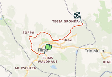
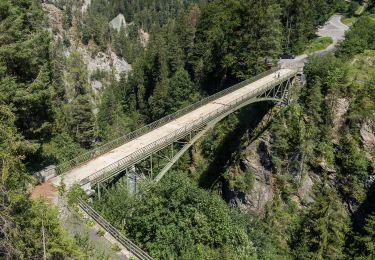
Tour Andere Aktivitäten von 8,5 km verfügbar auf Graubünden, Imboden, Flims. Diese Tour wird von jschna vorgeschlagen.
Beschreibung
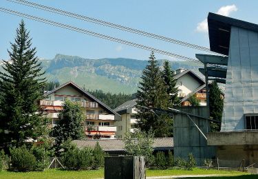
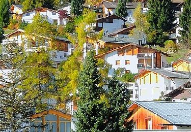
Unterhalb vom Hotel Chesa den Aufstieg über den signalisierten Wanderweg nehmen.
Über Spaligna nach Scheia, immer auf dem Höhenweg bis nach Bargis, wo sich ein leistungsfähiges Restaurant befindet und eine wunderschöne Aussicht ins Tal bietet.
Rückfahrt mit dem Bus (alle 30 Min.) nach Flims.
Ort
Kommentare
Touren in der Umgebung
![Tour Zu Fuß Flims - Conn - Cresta See - Photo](https://media.geolcdn.com/t/375/260/1e9e186c-c404-4d25-97ce-94522e729cc7.jpeg&format=jpg&maxdim=2)
![Zu Fuß Zu Fuß](https://static1.geolcdn.com/sitytour/trail-icons/100.png)
Zu Fuß
![](/images/other/stat-length.png)
![](https://static1.geolcdn.com/siteimages/upload/files/16400158638029165_repeat_loop_refresh_sync_direction_icon.png)
![Tour Zu Fuß Safiental - Station Versam-Safien - Versam - Photo](https://media.geolcdn.com/t/375/260/dev_6749a509-cf02-4174-9a3b-ba7f44fa5e7a.jpeg&format=jpg&maxdim=2)
![Zu Fuß Zu Fuß](https://static1.geolcdn.com/sitytour/trail-icons/100.png)
Zu Fuß
![](/images/other/stat-length.png)
![](https://static1.geolcdn.com/siteimages/upload/files/16400158638029165_repeat_loop_refresh_sync_direction_icon.png)
![Tour Zu Fuß Flims - Flims-Conn - Photo](https://media.geolcdn.com/t/375/260/1880d78b-ac46-4df8-8036-ec2998894eb0.jpeg&format=jpg&maxdim=2)
![Zu Fuß Zu Fuß](https://static1.geolcdn.com/sitytour/trail-icons/100.png)
Zu Fuß
![](/images/other/stat-length.png)
![](https://static1.geolcdn.com/siteimages/upload/files/16400158638029165_repeat_loop_refresh_sync_direction_icon.png)
![Tour Zu Fuß Laax - Curnius - Laax - Photo](https://media.geolcdn.com/t/375/260/d810f58f-ccd0-489f-b82a-e8d6a07ec481.jpeg&format=jpg&maxdim=2)
![Zu Fuß Zu Fuß](https://static1.geolcdn.com/sitytour/trail-icons/100.png)
Zu Fuß
![](/images/other/stat-length.png)
![](https://static1.geolcdn.com/siteimages/upload/files/16400158638029165_repeat_loop_refresh_sync_direction_icon.png)
![Tour Zu Fuß Falera - Curnius - Falera - Photo](https://media.geolcdn.com/t/375/260/be32cecb-6f68-4336-99b1-5c04a02da7b0.jpeg&format=jpg&maxdim=2)
![Zu Fuß Zu Fuß](https://static1.geolcdn.com/sitytour/trail-icons/100.png)
Zu Fuß
![](/images/other/stat-length.png)
![](https://static1.geolcdn.com/siteimages/upload/files/16400158638029165_repeat_loop_refresh_sync_direction_icon.png)
![Tour Zu Fuß Laax - Larnags-Runca-Flims - Photo](https://media.geolcdn.com/t/375/260/fa421d67-b970-4ac0-95a5-cc762e710df7.jpeg&format=jpg&maxdim=2)
![Zu Fuß Zu Fuß](https://static1.geolcdn.com/sitytour/trail-icons/100.png)
Zu Fuß
![](/images/other/stat-length.png)
![](https://static1.geolcdn.com/siteimages/upload/files/16400158638029165_repeat_loop_refresh_sync_direction_icon.png)
![Tour Zu Fuß Safiental - Valendas-Castrisch - Photo](https://media.geolcdn.com/t/375/260/7f6a0ff4-164c-4e87-9ce9-4e8c856a66ea.jpeg&format=jpg&maxdim=2)
![Zu Fuß Zu Fuß](https://static1.geolcdn.com/sitytour/trail-icons/100.png)
Zu Fuß
![](/images/other/stat-length.png)
![](https://static1.geolcdn.com/siteimages/upload/files/16400158638029165_repeat_loop_refresh_sync_direction_icon.png)
![Tour Zu Fuß Safiental - Versam - Carerra - Photo](https://media.geolcdn.com/t/375/260/a46c6e8a-f55a-413f-9275-4fd31e9d4b64.jpeg&format=jpg&maxdim=2)
![Zu Fuß Zu Fuß](https://static1.geolcdn.com/sitytour/trail-icons/100.png)
Zu Fuß
![](/images/other/stat-length.png)
![](https://static1.geolcdn.com/siteimages/upload/files/16400158638029165_repeat_loop_refresh_sync_direction_icon.png)
![Tour Zu Fuß Safiental - Station Versam-Station Valendas - Photo](https://media.geolcdn.com/t/375/260/dev_6749a509-cf02-4174-9a3b-ba7f44fa5e7a.jpeg&format=jpg&maxdim=2)
![Zu Fuß Zu Fuß](https://static1.geolcdn.com/sitytour/trail-icons/100.png)
Zu Fuß
![](/images/other/stat-length.png)
![](https://static1.geolcdn.com/siteimages/upload/files/16400158638029165_repeat_loop_refresh_sync_direction_icon.png)