![](/images/other/stat-length.png)
![Tour Wandern Saint-Cyr-la-Rosière - Au fil de la Rosière 7,1 Km - Photo](https://media.geolcdn.com/t/1900/400/6ffb02c5-f518-43cf-b25f-e24d8f031465.jpg&format=pjpeg&maxdim=2)
Au fil de la Rosière 7,1 Km
ODDAD78
Benutzer
![Länge](/images/other/stat-length.png)
![Maximale Höhe](https://static1.geolcdn.com/siteimages/upload/files/1508320355ic_sort_altitude_max_24dp.png)
![Positive Höhendifferenz](https://static1.geolcdn.com/siteimages/upload/files/1508320355ic_sort_den_pos_24dp.png)
![Km-Effort](/images/other/stat-length.png)
![Min. Höhe](https://static1.geolcdn.com/siteimages/upload/files/1508320355ic_sort_altitude_min_24dp.png)
![Negative Höhendifferenz](https://static1.geolcdn.com/siteimages/upload/files/1508320355ic_sort_den_neg_24dp.png)
![Boucle](https://static1.geolcdn.com/siteimages/upload/files/16400158638029165_repeat_loop_refresh_sync_direction_icon.png)
![Wandern](https://static1.geolcdn.com/sitytour/trail-icons/101.png)
1h57
Schwierigkeit : Medium
![Scannen Sie diesen QR-Code, um die Tour in der SityTrail-Anwendung zu öffnen](https://capi.geolives.com/qq0zvz2zws4bq2lad0pu/sitytour/trails/2023008/qr.png?size=200)
Kostenlosegpshiking-Anwendung
Über SityTrail
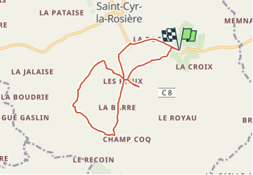
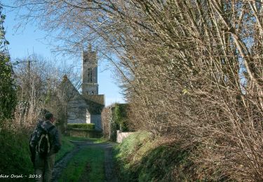
Tour Wandern von 7,1 km verfügbar auf Normandie, Orne, Saint-Cyr-la-Rosière. Diese Tour wird von ODDAD78 vorgeschlagen.
Beschreibung
Circuit balisé et jaune signalétique (suivre les flèches "Au fil de la Rosière")
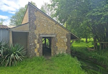
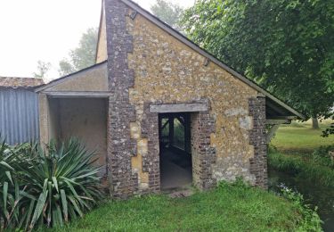
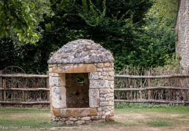
La Rosière figure parmi les anciennes seigneuries du Perche, Le premier château, construit sur une moite, a été rem- placé par un grand corps de logis comprenant notamment trois chambres basses et trois chambres hautes à cheminée, Dans le jardin clos de la ferme existe encore la chapelle Saint-Antoine, fondée en 1535 et, dans la cour, la tour ronde d’une fuie,
Commentaire :
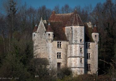
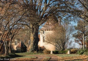
L'Angenardière, l'un des plus beaux manoirs du Perche, a une allure médiévale. Pierre de Fontenay, son constructeur, craignait-il un retour aux années sombres des Guerres de Religion où voulait-il posséder un château qui fasse honneur à ses titres de Gouverneur pour le roi des ville et châteou de Bellême et du pays du Perche.
Élevée sur un plan carré, la demeure est close de murs et de fossés. On pénétrait dans la basse-cour par un pont-levis, Le logis XVIé, flanqué de deux grosses tours rondes à mâchicoulis, est relié à l'une des tours d'angle par une élégante galerie “à l'italienne",
L'enceinte est soulignée par quatre tours. La plus massive est celle du colombier aux nombreux boulins, accessibles par une échelle tournante, La plus petite abritait la chapelle seigneuriale.
Ort
Kommentare
Touren in der Umgebung
![Tour Wandern Perche en Nocé - Préaux-du-Perche Nord - Photo](https://media.geolcdn.com/t/375/260/a79e2268-207b-49cb-8d2a-d633dd57f73d.jpg&format=jpg&maxdim=2)
![Wandern Wandern](https://static1.geolcdn.com/sitytour/trail-icons/101.png)
Wandern
![](/images/other/stat-length.png)
![](https://static1.geolcdn.com/siteimages/upload/files/16400158638029165_repeat_loop_refresh_sync_direction_icon.png)
![Tour Wandern La Chapelle-Souëf - La Chapelle Souef - Les Feugerets 12 Km - Photo](https://media.geolcdn.com/t/375/260/ext.jpg?maxdim=2&url=https%3A%2F%2Fstatic1.geolcdn.com%2Fsiteimages%2Fupload%2Ffiles%2F1553511878bg_sport_marche.png)
![Wandern Wandern](https://static1.geolcdn.com/sitytour/trail-icons/101.png)
Wandern
![](/images/other/stat-length.png)
![](https://static1.geolcdn.com/siteimages/upload/files/16400158638029165_repeat_loop_refresh_sync_direction_icon.png)
![Tour Wandern Perche en Nocé - Préaux-du-Perche Sud - Photo](https://media.geolcdn.com/t/375/260/0969c1bf-78c8-4ceb-9cf9-65ed34443adf.jpg&format=jpg&maxdim=2)
![Wandern Wandern](https://static1.geolcdn.com/sitytour/trail-icons/101.png)
Wandern
![](/images/other/stat-length.png)
![](https://static1.geolcdn.com/siteimages/upload/files/16400158638029165_repeat_loop_refresh_sync_direction_icon.png)
![Tour Wandern Perche en Nocé - Nocé-Courboyer - Saint-Aubin-des-Grois 9,5 km - Photo](https://media.geolcdn.com/t/375/260/74d7cd8d-75a9-4a6d-8570-ba2a55254fab.jpg&format=jpg&maxdim=2)
![Wandern Wandern](https://static1.geolcdn.com/sitytour/trail-icons/101.png)
Wandern
![](/images/other/stat-length.png)
![](https://static1.geolcdn.com/siteimages/upload/files/16400158638029165_repeat_loop_refresh_sync_direction_icon.png)
![Tour Wandern Perche en Nocé - Val d'Enfer 17Km - Photo](https://media.geolcdn.com/t/375/260/285f82a6-4b4a-437a-b428-48270f65e19b.jpg&format=jpg&maxdim=2)
![Wandern Wandern](https://static1.geolcdn.com/sitytour/trail-icons/101.png)
Wandern
![](/images/other/stat-length.png)
![](https://static1.geolcdn.com/siteimages/upload/files/16400158638029165_repeat_loop_refresh_sync_direction_icon.png)
![Tour Wandern Perche en Nocé - Nobles logis (Préaux-du-Perche) 9,4Km - Photo](https://media.geolcdn.com/t/375/260/4db8b454-889b-47d7-bd12-5d83e5cd02fb.jpg&format=jpg&maxdim=2)
![Wandern Wandern](https://static1.geolcdn.com/sitytour/trail-icons/101.png)
Wandern
![](/images/other/stat-length.png)
![](https://static1.geolcdn.com/siteimages/upload/files/16400158638029165_repeat_loop_refresh_sync_direction_icon.png)
![Tour Wandern Perche en Nocé - Les Panoramas 5,5 Km - Photo](https://media.geolcdn.com/t/375/260/3ecdb278-3826-4aa6-b1de-61f0366a9a2c.jpg&format=jpg&maxdim=2)
![Wandern Wandern](https://static1.geolcdn.com/sitytour/trail-icons/101.png)
Wandern
![](/images/other/stat-length.png)
![](https://static1.geolcdn.com/siteimages/upload/files/16400158638029165_repeat_loop_refresh_sync_direction_icon.png)
![Tour Wandern Val-au-Perche - Gémages - Igé 15 km - Photo](https://media.geolcdn.com/t/375/260/ca29e4ed-f1c5-43dc-8f3b-a7ce5ca4d85c.jpg&format=jpg&maxdim=2)
![Wandern Wandern](https://static1.geolcdn.com/sitytour/trail-icons/101.png)
Wandern
![](/images/other/stat-length.png)
![](https://static1.geolcdn.com/siteimages/upload/files/16400158638029165_repeat_loop_refresh_sync_direction_icon.png)
![Tour Wandern Val-au-Perche - Gémages - Igé via Appenai-sous-Bellême 17 km - Photo](https://media.geolcdn.com/t/375/260/ea7eb4fa-cd97-4b60-8fba-343bfd613697.jpg&format=jpg&maxdim=2)
![Wandern Wandern](https://static1.geolcdn.com/sitytour/trail-icons/101.png)
Wandern
![](/images/other/stat-length.png)
![](https://static1.geolcdn.com/siteimages/upload/files/16400158638029165_repeat_loop_refresh_sync_direction_icon.png)