![](/images/other/stat-length.png)
![Tour Wandern Châtelus - Le Pas des Voûtes - Le Pas de l'Allier - Photo](https://media.geolcdn.com/t/1900/400/25b5e517-6b79-4599-8a5d-71b3c16f8467.jpg&format=pjpeg&maxdim=2)
Le Pas des Voûtes - Le Pas de l'Allier
patjobou
Benutzer
![Länge](/images/other/stat-length.png)
Länge
11,8 km
![Maximale Höhe](https://static1.geolcdn.com/siteimages/upload/files/1508320355ic_sort_altitude_max_24dp.png)
Maximale Höhe
1259 m
![Positive Höhendifferenz](https://static1.geolcdn.com/siteimages/upload/files/1508320355ic_sort_den_pos_24dp.png)
Positive Höhendifferenz
931 m
![Km-Effort](/images/other/stat-length.png)
Km-Effort
24 km
![Min. Höhe](https://static1.geolcdn.com/siteimages/upload/files/1508320355ic_sort_altitude_min_24dp.png)
Min. Höhe
528 m
![Negative Höhendifferenz](https://static1.geolcdn.com/siteimages/upload/files/1508320355ic_sort_den_neg_24dp.png)
Negative Höhendifferenz
930 m
![Boucle](https://static1.geolcdn.com/siteimages/upload/files/16400158638029165_repeat_loop_refresh_sync_direction_icon.png)
Boucle
Ja
Erstellungsdatum :
2018-11-29 09:42:04.137
Letzte Änderung :
2018-12-03 22:22:21.862
![Wandern](https://static1.geolcdn.com/sitytour/trail-icons/101.png)
5h11
Schwierigkeit : Medium
![Scannen Sie diesen QR-Code, um die Tour in der SityTrail-Anwendung zu öffnen](https://capi.geolives.com/qq0zvz2zws4bq2lad0pu/sitytour/trails/2018245/qr.png?size=200)
Kostenlosegpshiking-Anwendung
Über SityTrail
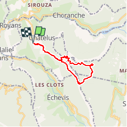
Tour Wandern von 11,8 km verfügbar auf Auvergne-Rhone-Alpen, Isère, Châtelus. Diese Tour wird von patjobou vorgeschlagen.
Beschreibung
Très belle boucle à travers des falaises typiques du Vercors. Itinéraire varié, beaux points de vue. La montée au Pas des Voûtes est soutenue, mais sur un bon sentier. Le denivelé cumulé est un peu surestimé: 800 m semblent plus corrects.
Ort
Land:
France
Region :
Auvergne-Rhone-Alpen
Abteilung/Provinz :
Isère
Kommune :
Châtelus
Standort:
Unknown
Gehen Sie:(Dec)
Gehen Sie:(UTM)
686437 ; 4991641 (31T) N.
Kommentare
Touren in der Umgebung
![Tour Wandern Châtelus - 38 bournillon porte du diable charmatte - Photo](https://media.geolcdn.com/t/375/260/d74c1d26-f2c4-4c87-8563-94950cba2a2c.jpg&format=jpg&maxdim=2)
![Wandern Wandern](https://static1.geolcdn.com/sitytour/trail-icons/101.png)
38 bournillon porte du diable charmatte
Wandern
Schwierig
(1)
Châtelus,
Auvergne-Rhone-Alpen,
Isère,
France
![](/images/other/stat-length.png)
16,5 km | 34 km-effort
8h 7min
![](https://static1.geolcdn.com/siteimages/upload/files/16400158638029165_repeat_loop_refresh_sync_direction_icon.png)
Ja
![Tour Wandern Châtelus - Boucle Pas de l'Allier - Pas des Voutes - Photo](https://media.geolcdn.com/t/375/260/ext.jpg?maxdim=2&url=https%3A%2F%2Fservices.sitytrail.com%2FGeolivesWS%2FDownloadMedia.ashx%3FTrailID%3D105085%26Media%3D8675_1.jpg)
![Wandern Wandern](https://static1.geolcdn.com/sitytour/trail-icons/101.png)
Boucle Pas de l'Allier - Pas des Voutes
Wandern
Medium
(1)
Châtelus,
Auvergne-Rhone-Alpen,
Isère,
France
![](/images/other/stat-length.png)
10,1 km | 22 km-effort
4h 30min
![](https://static1.geolcdn.com/siteimages/upload/files/16400158638029165_repeat_loop_refresh_sync_direction_icon.png)
Ja
![Tour Wandern Sainte-Eulalie-en-Royans - 26 ste eulalie - Photo](https://media.geolcdn.com/t/375/260/cc17d7c1-039b-4811-aa20-433bfbe37107.jpg&format=jpg&maxdim=2)
![Wandern Wandern](https://static1.geolcdn.com/sitytour/trail-icons/101.png)
26 ste eulalie
Wandern
Medium
Sainte-Eulalie-en-Royans,
Auvergne-Rhone-Alpen,
Drôme,
France
![](/images/other/stat-length.png)
14,8 km | 27 km-effort
6h 43min
![](https://static1.geolcdn.com/siteimages/upload/files/16400158638029165_repeat_loop_refresh_sync_direction_icon.png)
Nein
![Tour Wandern Châtelus - 38 pabro charmatte - Photo](https://media.geolcdn.com/t/375/260/983fca8d-ac95-4180-878f-eb8932bd4279.jpg&format=jpg&maxdim=2)
![Wandern Wandern](https://static1.geolcdn.com/sitytour/trail-icons/101.png)
38 pabro charmatte
Wandern
Schwierig
Châtelus,
Auvergne-Rhone-Alpen,
Isère,
France
![](/images/other/stat-length.png)
11,4 km | 29 km-effort
7h 43min
![](https://static1.geolcdn.com/siteimages/upload/files/16400158638029165_repeat_loop_refresh_sync_direction_icon.png)
Ja
![Tour Wandern Pont-en-Royans - 38 pont en Royans choranche presles - Photo](https://media.geolcdn.com/t/375/260/55a7031b-27da-4fe2-88f7-a5894b7e1ffc.jpg&format=jpg&maxdim=2)
![Wandern Wandern](https://static1.geolcdn.com/sitytour/trail-icons/101.png)
38 pont en Royans choranche presles
Wandern
Schwierig
Pont-en-Royans,
Auvergne-Rhone-Alpen,
Isère,
France
![](/images/other/stat-length.png)
15,4 km | 30 km-effort
6h 52min
![](https://static1.geolcdn.com/siteimages/upload/files/16400158638029165_repeat_loop_refresh_sync_direction_icon.png)
Ja
![Tour Wandern Pont-en-Royans - 38 pont en Royans st andre - Photo](https://media.geolcdn.com/t/375/260/9999e3ad-9f99-41dc-bf89-768d521527c3.jpg&format=jpg&maxdim=2)
![Wandern Wandern](https://static1.geolcdn.com/sitytour/trail-icons/101.png)
38 pont en Royans st andre
Wandern
Einfach
Pont-en-Royans,
Auvergne-Rhone-Alpen,
Isère,
France
![](/images/other/stat-length.png)
14,1 km | 19,3 km-effort
3h 33min
![](https://static1.geolcdn.com/siteimages/upload/files/16400158638029165_repeat_loop_refresh_sync_direction_icon.png)
Ja
![Tour Wandern Pont-en-Royans - 38 pont en Royans serre cocu - Photo](https://media.geolcdn.com/t/375/260/72853ffa-a2a8-4453-a880-6a63c61d611f.jpg&format=jpg&maxdim=2)
![Wandern Wandern](https://static1.geolcdn.com/sitytour/trail-icons/101.png)
38 pont en Royans serre cocu
Wandern
Medium
Pont-en-Royans,
Auvergne-Rhone-Alpen,
Isère,
France
![](/images/other/stat-length.png)
16 km | 29 km-effort
7h 44min
![](https://static1.geolcdn.com/siteimages/upload/files/16400158638029165_repeat_loop_refresh_sync_direction_icon.png)
Ja
![Tour Wandern Châtelus - la grande cournouse - Photo](https://media.geolcdn.com/t/375/260/81ce0c57-e303-433f-a090-0d0401f39630.jpg&format=jpg&maxdim=2)
![Wandern Wandern](https://static1.geolcdn.com/sitytour/trail-icons/101.png)
la grande cournouse
Wandern
Schwierig
Châtelus,
Auvergne-Rhone-Alpen,
Isère,
France
![](/images/other/stat-length.png)
10,5 km | 26 km-effort
6h 34min
![](https://static1.geolcdn.com/siteimages/upload/files/16400158638029165_repeat_loop_refresh_sync_direction_icon.png)
Ja
![Tour Wandern Châtelus - la grotte des Gaulois, le pas de l' Echarasson, porte du diable, pas de charmate - Photo](https://media.geolcdn.com/t/375/260/c1c947db-e815-4652-a05d-cf71b9e7231f.jpg&format=jpg&maxdim=2)
![Wandern Wandern](https://static1.geolcdn.com/sitytour/trail-icons/101.png)
la grotte des Gaulois, le pas de l' Echarasson, porte du diable, pas de charmate
Wandern
Schwierig
Châtelus,
Auvergne-Rhone-Alpen,
Isère,
France
![](/images/other/stat-length.png)
18,3 km | 37 km-effort
8h 23min
![](https://static1.geolcdn.com/siteimages/upload/files/16400158638029165_repeat_loop_refresh_sync_direction_icon.png)
Ja