![](/images/other/stat-length.png)
![Tour Wandern Hulluch - Campagne au milieu des](https://media.geolcdn.com/t/1900/400/ext.pjpeg?maxdim=2&url=https%3A%2F%2Fstatic1.geolcdn.com%2Fsiteimages%2Fupload%2Ffiles%2F1553511878bg_sport_marche.png)
Campagne au milieu des "champs de mines"
dautriche
Benutzer
![Länge](/images/other/stat-length.png)
Länge
21 km
![Maximale Höhe](https://static1.geolcdn.com/siteimages/upload/files/1508320355ic_sort_altitude_max_24dp.png)
Maximale Höhe
50 m
![Positive Höhendifferenz](https://static1.geolcdn.com/siteimages/upload/files/1508320355ic_sort_den_pos_24dp.png)
Positive Höhendifferenz
98 m
![Km-Effort](/images/other/stat-length.png)
Km-Effort
22 km
![Min. Höhe](https://static1.geolcdn.com/siteimages/upload/files/1508320355ic_sort_altitude_min_24dp.png)
Min. Höhe
19 m
![Negative Höhendifferenz](https://static1.geolcdn.com/siteimages/upload/files/1508320355ic_sort_den_neg_24dp.png)
Negative Höhendifferenz
98 m
![Boucle](https://static1.geolcdn.com/siteimages/upload/files/16400158638029165_repeat_loop_refresh_sync_direction_icon.png)
Boucle
Ja
Erstellungsdatum :
2018-11-22 12:42:22.655
Letzte Änderung :
2018-11-22 18:17:08.263
![Wandern](https://static1.geolcdn.com/sitytour/trail-icons/101.png)
4h59
Schwierigkeit : Einfach
![Scannen Sie diesen QR-Code, um die Tour in der SityTrail-Anwendung zu öffnen](https://capi.geolives.com/qq0zvz2zws4bq2lad0pu/sitytour/trails/2017523/qr.png?size=200)
Kostenlosegpshiking-Anwendung
Über SityTrail
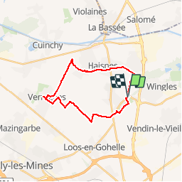
Tour Wandern von 21 km verfügbar auf Nordfrankreich, Pas-de-Calais, Hulluch. Diese Tour wird von dautriche vorgeschlagen.
Beschreibung
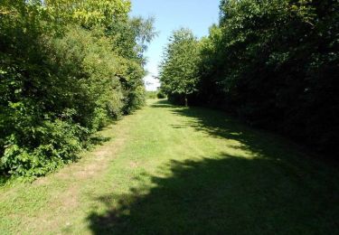
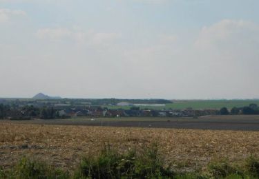
Etonnante campagne "vierge" autour du terril de la fosse 13 et au milieu des fosses du bassin minier de Lens et Béthune. 21 km de nature surprenante dans ce paysage imaginé comme urbain proche du siège de la fosse Germinal ...
Ort
Land:
France
Region :
Nordfrankreich
Abteilung/Provinz :
Pas-de-Calais
Kommune :
Hulluch
Standort:
Unknown
Gehen Sie:(Dec)
Gehen Sie:(UTM)
487611 ; 5592947 (31U) N.
Kommentare
Touren in der Umgebung
![Tour Hybrid-Bike Wingles - Wingles parc de la souchez - Photo](https://media.geolcdn.com/t/375/260/ext.jpg?maxdim=2&url=https%3A%2F%2Fstatic1.geolcdn.com%2Fsiteimages%2Fupload%2Ffiles%2F1524743154velo.jpg)
![Hybrid-Bike Hybrid-Bike](https://static1.geolcdn.com/sitytour/trail-icons/203.png)
Wingles parc de la souchez
Hybrid-Bike
(1)
Wingles,
Nordfrankreich,
Pas-de-Calais,
France
![](/images/other/stat-length.png)
34 km | 36 km-effort
1h 53min
![](https://static1.geolcdn.com/siteimages/upload/files/16400158638029165_repeat_loop_refresh_sync_direction_icon.png)
Ja
![Tour Wandern Wingles - wingles reco - Photo](https://media.geolcdn.com/t/375/260/d31f0e14-4502-46fe-8a48-24e58a4b23d3.jpg&format=jpg&maxdim=2)
![Wandern Wandern](https://static1.geolcdn.com/sitytour/trail-icons/101.png)
wingles reco
Wandern
Medium
Wingles,
Nordfrankreich,
Pas-de-Calais,
France
![](/images/other/stat-length.png)
10,2 km | 11,2 km-effort
1h 53min
![](https://static1.geolcdn.com/siteimages/upload/files/16400158638029165_repeat_loop_refresh_sync_direction_icon.png)
Ja
![Tour Wandern La Bassée - La Basée 13 km - Photo](https://media.geolcdn.com/t/375/260/f1bdc64b-513c-470e-8886-00ca936919a9.jpg&format=jpg&maxdim=2)
![Wandern Wandern](https://static1.geolcdn.com/sitytour/trail-icons/101.png)
La Basée 13 km
Wandern
Einfach
La Bassée,
Nordfrankreich,
Nord,
France
![](/images/other/stat-length.png)
13 km | 13,7 km-effort
3h 26min
![](https://static1.geolcdn.com/siteimages/upload/files/16400158638029165_repeat_loop_refresh_sync_direction_icon.png)
Ja
![Tour Wandern Bauvin - Wingles - Photo](https://media.geolcdn.com/t/375/260/4ad96d20-0522-45e1-a005-6177e2c8edea.jpg&format=jpg&maxdim=2)
![Wandern Wandern](https://static1.geolcdn.com/sitytour/trail-icons/101.png)
![Tour Elektrofahrrad Wingles - Wingles BÈthune vimy - Photo](https://media.geolcdn.com/t/375/260/1f50935e-e323-432c-ae4c-ec8457404502.jpg&format=jpg&maxdim=2)
![Elektrofahrrad Elektrofahrrad](https://static1.geolcdn.com/sitytour/trail-icons/205.png)
Wingles BÈthune vimy
Elektrofahrrad
Medium
Wingles,
Nordfrankreich,
Pas-de-Calais,
France
![](/images/other/stat-length.png)
82 km | 92 km-effort
5h 32min
![](https://static1.geolcdn.com/siteimages/upload/files/16400158638029165_repeat_loop_refresh_sync_direction_icon.png)
Ja
![Tour Wandern Haisnes - La gare - Haisnes - Photo](https://media.geolcdn.com/t/375/260/ext.jpg?maxdim=2&url=https%3A%2F%2Fservices.sitytrail.com%2FGeolivesWS%2FDownloadMedia.ashx%3FTrailID%3D317367%26Media%3D16587_6.jpg)
![Wandern Wandern](https://static1.geolcdn.com/sitytour/trail-icons/101.png)
La gare - Haisnes
Wandern
Medium
Haisnes,
Nordfrankreich,
Pas-de-Calais,
France
![](/images/other/stat-length.png)
10,1 km | 10,8 km-effort
2h 30min
![](https://static1.geolcdn.com/siteimages/upload/files/16400158638029165_repeat_loop_refresh_sync_direction_icon.png)
Ja
![Tour Wandern Billy-Berclau - Le chemin vert - Billy-Berclau - Photo](https://media.geolcdn.com/t/375/260/ext.jpg?maxdim=2&url=https%3A%2F%2Fservices.sitytrail.com%2FGeolivesWS%2FDownloadMedia.ashx%3FTrailID%3D317354%26Media%3D16572_6.jpg)
![Wandern Wandern](https://static1.geolcdn.com/sitytour/trail-icons/101.png)
Le chemin vert - Billy-Berclau
Wandern
Medium
Billy-Berclau,
Nordfrankreich,
Pas-de-Calais,
France
![](/images/other/stat-length.png)
9,2 km | 9,7 km-effort
2h 15min
![](https://static1.geolcdn.com/siteimages/upload/files/16400158638029165_repeat_loop_refresh_sync_direction_icon.png)
Ja
![Tour Wandern Auchy-les-Mines - Les Briques - Auchy les Mines - Photo](https://media.geolcdn.com/t/375/260/ext.jpg?maxdim=2&url=https%3A%2F%2Fservices.sitytrail.com%2FGeolivesWS%2FDownloadMedia.ashx%3FTrailID%3D317101%26Media%3D16249_6.jpg)
![Wandern Wandern](https://static1.geolcdn.com/sitytour/trail-icons/101.png)
Les Briques - Auchy les Mines
Wandern
Einfach
Auchy-les-Mines,
Nordfrankreich,
Pas-de-Calais,
France
![](/images/other/stat-length.png)
6,7 km | 7 km-effort
1h 40min
![](https://static1.geolcdn.com/siteimages/upload/files/16400158638029165_repeat_loop_refresh_sync_direction_icon.png)
Ja
![Tour Fahrrad Wingles - Les parcs - Wingles - Photo](https://media.geolcdn.com/t/375/260/ext.jpg?maxdim=2&url=https%3A%2F%2Fservices.sitytrail.com%2FGeolivesWS%2FDownloadMedia.ashx%3FTrailID%3D316911%26Media%3D16010_5.jpg)
![Fahrrad Fahrrad](https://static1.geolcdn.com/sitytour/trail-icons/200.png)
Les parcs - Wingles
Fahrrad
Einfach
(1)
Wingles,
Nordfrankreich,
Pas-de-Calais,
France
![](/images/other/stat-length.png)
29 km | 31 km-effort
2h 0min
![](https://static1.geolcdn.com/siteimages/upload/files/16400158638029165_repeat_loop_refresh_sync_direction_icon.png)
Ja