![](/images/other/stat-length.png)
La_Fayette_Ruisseau
jagarnier
Benutzer GUIDE
![Länge](/images/other/stat-length.png)
Länge
10,3 km
![Maximale Höhe](https://static1.geolcdn.com/siteimages/upload/files/1508320355ic_sort_altitude_max_24dp.png)
Maximale Höhe
1076 m
![Positive Höhendifferenz](https://static1.geolcdn.com/siteimages/upload/files/1508320355ic_sort_den_pos_24dp.png)
Positive Höhendifferenz
270 m
![Km-Effort](/images/other/stat-length.png)
Km-Effort
13,9 km
![Min. Höhe](https://static1.geolcdn.com/siteimages/upload/files/1508320355ic_sort_altitude_min_24dp.png)
Min. Höhe
860 m
![Negative Höhendifferenz](https://static1.geolcdn.com/siteimages/upload/files/1508320355ic_sort_den_neg_24dp.png)
Negative Höhendifferenz
270 m
![Boucle](https://static1.geolcdn.com/siteimages/upload/files/16400158638029165_repeat_loop_refresh_sync_direction_icon.png)
Boucle
Ja
Erstellungsdatum :
2018-11-02 13:57:51.463
Letzte Änderung :
2023-10-25 15:55:33.346
![Wandern](https://static1.geolcdn.com/sitytour/trail-icons/101.png)
3h00
Schwierigkeit : Medium
![Scannen Sie diesen QR-Code, um die Tour in der SityTrail-Anwendung zu öffnen](https://capi.geolives.com/qq0zvz2zws4bq2lad0pu/sitytour/trails/2015332/qr.png?size=200)
Kostenlosegpshiking-Anwendung
Über SityTrail
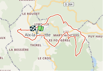
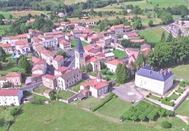
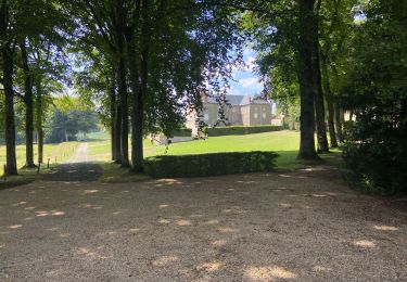
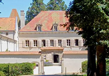
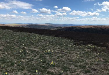
Tour Wandern von 10,3 km verfügbar auf Auvergne-Rhone-Alpen, Puy-de-Dôme, Aix-la-Fayette. Diese Tour wird von jagarnier vorgeschlagen.
Beschreibung
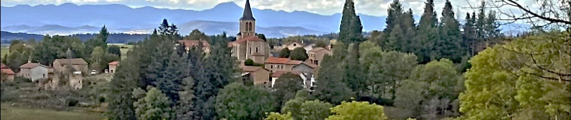
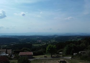
Cet itinéraire est dédié au château de la famille du célèbre général Lafayette. Depuis un village typique du Livradois aux maisons en granite, vous surplomberez le Cézallier et le Sancy.
Ort
Land:
France
Region :
Auvergne-Rhone-Alpen
Abteilung/Provinz :
Puy-de-Dôme
Kommune :
Aix-la-Fayette
Standort:
Unknown
Gehen Sie:(Dec)
Gehen Sie:(UTM)
540718 ; 5040506 (31T) N.
Kommentare
Touren in der Umgebung
![Tour Zu Fuß Échandelys - Le Buisson - Photo](https://media.geolcdn.com/t/375/260/cfc66893-0e5b-4243-88b5-55a86ae1921c.jpeg&format=jpg&maxdim=2)
![Zu Fuß Zu Fuß](https://static1.geolcdn.com/sitytour/trail-icons/100.png)
Le Buisson
Zu Fuß
Einfach
Échandelys,
Auvergne-Rhone-Alpen,
Puy-de-Dôme,
France
![](/images/other/stat-length.png)
7,4 km | 10 km-effort
2h 16min
![](https://static1.geolcdn.com/siteimages/upload/files/16400158638029165_repeat_loop_refresh_sync_direction_icon.png)
Ja
![Tour Zu Fuß Échandelys - Les Panoramas - Photo](https://media.geolcdn.com/t/375/260/b6c9543d-d4b0-4e45-81bf-a2b7f1258d7e.jpeg&format=jpg&maxdim=2)
![Zu Fuß Zu Fuß](https://static1.geolcdn.com/sitytour/trail-icons/100.png)
Les Panoramas
Zu Fuß
Einfach
Échandelys,
Auvergne-Rhone-Alpen,
Puy-de-Dôme,
France
![](/images/other/stat-length.png)
13,7 km | 18,4 km-effort
4h 10min
![](https://static1.geolcdn.com/siteimages/upload/files/16400158638029165_repeat_loop_refresh_sync_direction_icon.png)
Ja
![Tour Zu Fuß Fournols - Les Deux-Frères - Photo](https://media.geolcdn.com/t/375/260/d5784189-973d-43a7-a97f-cca4aab8ee4e.jpeg&format=jpg&maxdim=2)
![Zu Fuß Zu Fuß](https://static1.geolcdn.com/sitytour/trail-icons/100.png)
Les Deux-Frères
Zu Fuß
Einfach
Fournols,
Auvergne-Rhone-Alpen,
Puy-de-Dôme,
France
![](/images/other/stat-length.png)
12,2 km | 16,8 km-effort
3h 48min
![](https://static1.geolcdn.com/siteimages/upload/files/16400158638029165_repeat_loop_refresh_sync_direction_icon.png)
Ja
![Tour Zu Fuß Fournols - Fournols - Puy du Sapt - Photo](https://media.geolcdn.com/t/375/260/bb2da9db-eba2-4b2a-a77a-8a634280fa0e.jpeg&format=jpg&maxdim=2)
![Zu Fuß Zu Fuß](https://static1.geolcdn.com/sitytour/trail-icons/100.png)
Fournols - Puy du Sapt
Zu Fuß
Einfach
Fournols,
Auvergne-Rhone-Alpen,
Puy-de-Dôme,
France
![](/images/other/stat-length.png)
8,7 km | 11,1 km-effort
2h 31min
![](https://static1.geolcdn.com/siteimages/upload/files/16400158638029165_repeat_loop_refresh_sync_direction_icon.png)
Ja
![Tour Wandern Échandelys - Echandelys_Panoramas - Photo](https://media.geolcdn.com/t/375/260/7ec13047-d9df-4116-9a4e-65cdef27f29f.jpg&format=jpg&maxdim=2)
![Wandern Wandern](https://static1.geolcdn.com/sitytour/trail-icons/101.png)
Echandelys_Panoramas
Wandern
Medium
Échandelys,
Auvergne-Rhone-Alpen,
Puy-de-Dôme,
France
![](/images/other/stat-length.png)
12,7 km | 17,4 km-effort
3h 45min
![](https://static1.geolcdn.com/siteimages/upload/files/16400158638029165_repeat_loop_refresh_sync_direction_icon.png)
Ja
![Tour Wandern Échandelys - Panorama en Livradois-Forez - Photo](https://media.geolcdn.com/t/375/260/34db6a6d-9e7c-42d5-8fbe-73bdf7138b85.jpg&format=jpg&maxdim=2)
![Wandern Wandern](https://static1.geolcdn.com/sitytour/trail-icons/101.png)
Panorama en Livradois-Forez
Wandern
Einfach
Échandelys,
Auvergne-Rhone-Alpen,
Puy-de-Dôme,
France
![](/images/other/stat-length.png)
13,3 km | 18,1 km-effort
3h 42min
![](https://static1.geolcdn.com/siteimages/upload/files/16400158638029165_repeat_loop_refresh_sync_direction_icon.png)
Ja
![Tour Wandern Condat-lès-Montboissier - Condat_Liberty_1 - Photo](https://media.geolcdn.com/t/375/260/878a6fed-8dfd-48b6-9a9c-a289adf06608.jpg&format=jpg&maxdim=2)
![Wandern Wandern](https://static1.geolcdn.com/sitytour/trail-icons/101.png)
Condat_Liberty_1
Wandern
Medium
Condat-lès-Montboissier,
Auvergne-Rhone-Alpen,
Puy-de-Dôme,
France
![](/images/other/stat-length.png)
15,9 km | 21 km-effort
4h 45min
![](https://static1.geolcdn.com/siteimages/upload/files/16400158638029165_repeat_loop_refresh_sync_direction_icon.png)
Ja
![Tour Zu Fuß Le Vernet-Chaméane - Le Moulin-de-la-Rode - Photo](https://media.geolcdn.com/t/375/260/635e3282-1fe5-4e9f-8f0d-12e4924c53ea.jpeg&format=jpg&maxdim=2)
![Zu Fuß Zu Fuß](https://static1.geolcdn.com/sitytour/trail-icons/100.png)
Le Moulin-de-la-Rode
Zu Fuß
Einfach
Le Vernet-Chaméane,
Auvergne-Rhone-Alpen,
Puy-de-Dôme,
France
![](/images/other/stat-length.png)
11,5 km | 16,1 km-effort
3h 39min
![](https://static1.geolcdn.com/siteimages/upload/files/16400158638029165_repeat_loop_refresh_sync_direction_icon.png)
Ja
![Tour Zu Fuß Aix-la-Fayette - Le Château de la Fayette - Photo](https://media.geolcdn.com/t/375/260/ext.jpg?maxdim=2&url=https%3A%2F%2Fstatic1.geolcdn.com%2Fsiteimages%2Fupload%2Ffiles%2F1545311037marcheuse_200dpi.jpg)
![Zu Fuß Zu Fuß](https://static1.geolcdn.com/sitytour/trail-icons/100.png)
Le Château de la Fayette
Zu Fuß
Einfach
Aix-la-Fayette,
Auvergne-Rhone-Alpen,
Puy-de-Dôme,
France
![](/images/other/stat-length.png)
7,7 km | 11 km-effort
2h 30min
![](https://static1.geolcdn.com/siteimages/upload/files/16400158638029165_repeat_loop_refresh_sync_direction_icon.png)
Ja