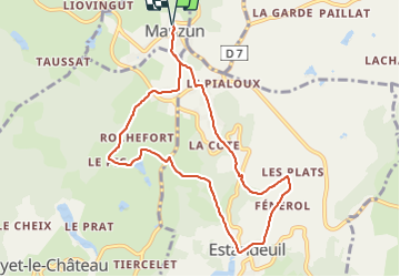
![](/images/other/stat-length.png)
Mauzun_Chateau
jagarnier
Benutzer GUIDE
![Länge](/images/other/stat-length.png)
![Maximale Höhe](https://static1.geolcdn.com/siteimages/upload/files/1508320355ic_sort_altitude_max_24dp.png)
![Positive Höhendifferenz](https://static1.geolcdn.com/siteimages/upload/files/1508320355ic_sort_den_pos_24dp.png)
![Km-Effort](/images/other/stat-length.png)
![Min. Höhe](https://static1.geolcdn.com/siteimages/upload/files/1508320355ic_sort_altitude_min_24dp.png)
![Negative Höhendifferenz](https://static1.geolcdn.com/siteimages/upload/files/1508320355ic_sort_den_neg_24dp.png)
![Boucle](https://static1.geolcdn.com/siteimages/upload/files/16400158638029165_repeat_loop_refresh_sync_direction_icon.png)
![Wandern](https://static1.geolcdn.com/sitytour/trail-icons/101.png)
2h45
Schwierigkeit : Medium
![Scannen Sie diesen QR-Code, um die Tour in der SityTrail-Anwendung zu öffnen](https://capi.geolives.com/qq0zvz2zws4bq2lad0pu/sitytour/trails/2015251/qr.png?size=200)
Kostenlosegpshiking-Anwendung
Über SityTrail
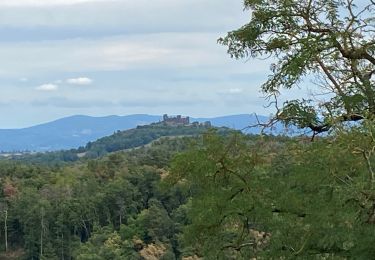
Tour Wandern von 8,9 km verfügbar auf Auvergne-Rhone-Alpen, Puy-de-Dôme, Mauzun. Diese Tour wird von jagarnier vorgeschlagen.
Beschreibung
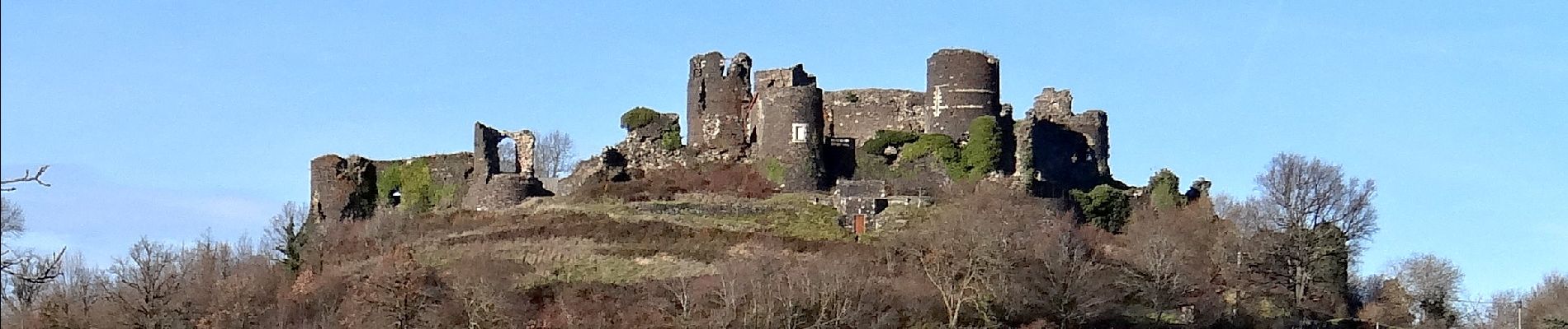
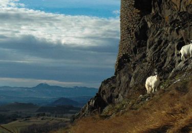
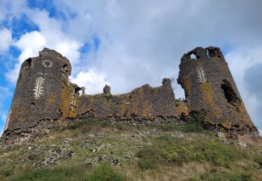
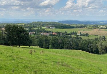
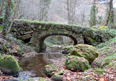
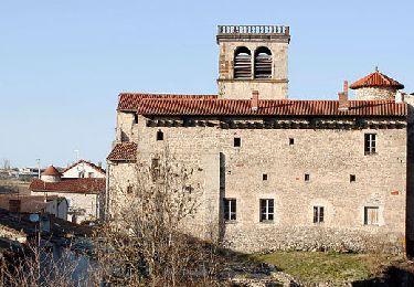
Ce château du XIIIe siècle est l'une des plus importantes places fortes de son époque. Sa position sur une butte volcanique était hautement stratégique. C’est une randonnée agréable pour le charme des paysages et des points de vue imprenables.
Photos sur :
https://u.pcloud.link/publink/show?code=XZrs2YkZ1SgQhTszBOpwQobUYcKdFh7rTdSV
Ort
Kommentare
Touren in der Umgebung
![Tour Zu Fuß Égliseneuve-près-Billom - Egliseneuve-près-Billom - Saint-Jean-des-Ollières - Photo](https://media.geolcdn.com/t/375/260/37c6e52b-d429-4f79-ab40-81ca434effbe.jpeg&format=jpg&maxdim=2)
![Zu Fuß Zu Fuß](https://static1.geolcdn.com/sitytour/trail-icons/100.png)
Zu Fuß
![](/images/other/stat-length.png)
![](https://static1.geolcdn.com/siteimages/upload/files/16400158638029165_repeat_loop_refresh_sync_direction_icon.png)
![Tour Zu Fuß Saint-Dier-d'Auvergne - Des Ribes au Miodet - Photo](https://media.geolcdn.com/t/375/260/3eaf22db-7235-4d7c-b6de-2e786297c48d.jpeg&format=jpg&maxdim=2)
![Zu Fuß Zu Fuß](https://static1.geolcdn.com/sitytour/trail-icons/100.png)
Zu Fuß
![](/images/other/stat-length.png)
![](https://static1.geolcdn.com/siteimages/upload/files/16400158638029165_repeat_loop_refresh_sync_direction_icon.png)
![Tour Zu Fuß Mauzun - Le Chateau de Mauzun - Photo](https://media.geolcdn.com/t/375/260/be6d961c-dee8-4c97-a23a-1073ebeca283.jpeg&format=jpg&maxdim=2)
![Zu Fuß Zu Fuß](https://static1.geolcdn.com/sitytour/trail-icons/100.png)
Zu Fuß
![](/images/other/stat-length.png)
![](https://static1.geolcdn.com/siteimages/upload/files/16400158638029165_repeat_loop_refresh_sync_direction_icon.png)
![Tour Wandern Fayet-le-Château - Ronde des fours - Photo](https://media.geolcdn.com/t/375/260/e433297a-3dcb-40fe-9fd1-fddeffe80b31.jpg&format=jpg&maxdim=2)
![Wandern Wandern](https://static1.geolcdn.com/sitytour/trail-icons/101.png)
Wandern
![](/images/other/stat-length.png)
![](https://static1.geolcdn.com/siteimages/upload/files/16400158638029165_repeat_loop_refresh_sync_direction_icon.png)
![Tour Wandern Bongheat - bongheat-Mauzun_T - Photo](https://media.geolcdn.com/t/375/260/7f635806-0acb-425b-8038-c52398fca600.jpg&format=jpg&maxdim=2)
![Wandern Wandern](https://static1.geolcdn.com/sitytour/trail-icons/101.png)
Wandern
![](/images/other/stat-length.png)
![](https://static1.geolcdn.com/siteimages/upload/files/16400158638029165_repeat_loop_refresh_sync_direction_icon.png)
![Tour Wandern Trézioux - La ronde des Grüns de Trézioux - Photo](https://media.geolcdn.com/t/375/260/fbc36beb-4703-4f16-8ba5-584236f20e9e.jpeg&format=jpg&maxdim=2)
![Wandern Wandern](https://static1.geolcdn.com/sitytour/trail-icons/101.png)
Wandern
![](/images/other/stat-length.png)
![](https://static1.geolcdn.com/siteimages/upload/files/16400158638029165_repeat_loop_refresh_sync_direction_icon.png)
![Tour Wandern Égliseneuve-près-Billom - Egliseneuve_Madet - Photo](https://media.geolcdn.com/t/375/260/477f218d-f91e-41b8-b984-1f348fbfff5f.jpg&format=jpg&maxdim=2)
![Wandern Wandern](https://static1.geolcdn.com/sitytour/trail-icons/101.png)
Wandern
![](/images/other/stat-length.png)
![](https://static1.geolcdn.com/siteimages/upload/files/16400158638029165_repeat_loop_refresh_sync_direction_icon.png)
![Tour Wandern Saint-Dier-d'Auvergne - St_Dier_Ribes_Miodet - Photo](https://media.geolcdn.com/t/375/260/1ad077f2-ac13-4fa4-8893-456994b8d19d.jpg&format=jpg&maxdim=2)
![Wandern Wandern](https://static1.geolcdn.com/sitytour/trail-icons/101.png)
Wandern
![](/images/other/stat-length.png)
![](https://static1.geolcdn.com/siteimages/upload/files/16400158638029165_repeat_loop_refresh_sync_direction_icon.png)
![Tour Wandern Égliseneuve-près-Billom - Château de Montmorin - Photo](https://media.geolcdn.com/t/375/260/8b1aa295-6dba-4d1e-ae17-fbe4f9adc7f6.jpg&format=jpg&maxdim=2)
![Wandern Wandern](https://static1.geolcdn.com/sitytour/trail-icons/101.png)
Wandern
![](/images/other/stat-length.png)
![](https://static1.geolcdn.com/siteimages/upload/files/16400158638029165_repeat_loop_refresh_sync_direction_icon.png)