![](/images/other/stat-length.png)
![Tour Wandern Capoulet-et-Junac - Tour de la bouiche de Gesties - Photo](https://media.geolcdn.com/t/1900/400/ba0a2fd5-5f69-46ff-b270-5e49916fe0c2.jpg&format=pjpeg&maxdim=2)
Tour de la bouiche de Gesties
c.chehere
Benutzer
![Länge](/images/other/stat-length.png)
Länge
17,3 km
![Boucle](https://static1.geolcdn.com/siteimages/upload/files/16400158638029165_repeat_loop_refresh_sync_direction_icon.png)
Boucle
Ja
Erstellungsdatum :
2018-10-02 06:34:18.649
Letzte Änderung :
2018-10-02 16:09:50.606
![Wandern](https://static1.geolcdn.com/sitytour/trail-icons/101.png)
7h40
Schwierigkeit : Schwierig
![Scannen Sie diesen QR-Code, um die Tour in der SityTrail-Anwendung zu öffnen](https://capi.geolives.com/qq0zvz2zws4bq2lad0pu/sitytour/trails/2012120/qr.png?size=200)
Kostenlosegpshiking-Anwendung
Über SityTrail
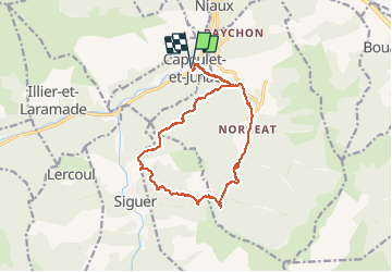
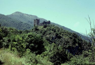
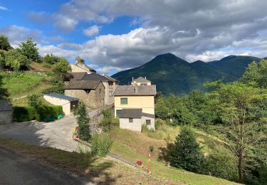
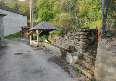
Tour Wandern von 17,3 km verfügbar auf Okzitanien, Ariège, Capoulet-et-Junac. Diese Tour wird von c.chehere vorgeschlagen.
Beschreibung
Départ depuis Capoulet. Sans problème juste la montée au col de Gamel à partir de Norgeat très raide.
Attention la partie de sentier dans la bois de Nayan complètement envahi par la végétation.
Balisage dans les autres parties correct (jaune et GR)
Ort
Land:
France
Region :
Okzitanien
Abteilung/Provinz :
Ariège
Kommune :
Capoulet-et-Junac
Standort:
Unknown
Gehen Sie:(Dec)
Gehen Sie:(UTM)
384202 ; 4739028 (31T) N.
Kommentare
Touren in der Umgebung
![Tour Wandern Gourbit - 04/06/2014 Rando Etang d'Artax - Photo](https://media.geolcdn.com/t/375/260/ext.jpg?maxdim=2&url=https%3A%2F%2Fservices.sitytrail.com%2FGeolivesWS%2FDownloadMedia.ashx%3FTrailID%3D308062%26Media%3D20140601132627.jpg)
![Wandern Wandern](https://static1.geolcdn.com/sitytour/trail-icons/101.png)
04/06/2014 Rando Etang d'Artax
Wandern
Schwierig
(1)
Gourbit,
Okzitanien,
Ariège,
France
![](/images/other/stat-length.png)
10,8 km | 24 km-effort
2h 53min
![](https://static1.geolcdn.com/siteimages/upload/files/16400158638029165_repeat_loop_refresh_sync_direction_icon.png)
Ja
![Tour Elektrofahrrad Niaux - Niaux - Photo](https://media.geolcdn.com/t/375/260/2925b5db-f18d-4157-bbef-94a57335fc75.jpg&format=jpg&maxdim=2)
![Elektrofahrrad Elektrofahrrad](https://static1.geolcdn.com/sitytour/trail-icons/205.png)
![Tour Elektrofahrrad Niaux - Château Miglos - Photo](https://media.geolcdn.com/t/375/260/8bba2701-86a9-409d-bc1b-998f1da97a1d.jpg&format=jpg&maxdim=2)
![Elektrofahrrad Elektrofahrrad](https://static1.geolcdn.com/sitytour/trail-icons/205.png)
Château Miglos
Elektrofahrrad
Sehr leicht
Niaux,
Okzitanien,
Ariège,
France
![](/images/other/stat-length.png)
8,1 km | 11 km-effort
45min
![](https://static1.geolcdn.com/siteimages/upload/files/16400158638029165_repeat_loop_refresh_sync_direction_icon.png)
Nein
![Tour Zu Fuß Lapège - Lapège et Pladetis - Photo](https://media.geolcdn.com/t/375/260/acf32a31-72a6-4e31-a909-32a8fa5a01b2.jpeg&format=jpg&maxdim=2)
![Zu Fuß Zu Fuß](https://static1.geolcdn.com/sitytour/trail-icons/100.png)
Lapège et Pladetis
Zu Fuß
Einfach
Lapège,
Okzitanien,
Ariège,
France
![](/images/other/stat-length.png)
10,1 km | 18,8 km-effort
4h 16min
![](https://static1.geolcdn.com/siteimages/upload/files/16400158638029165_repeat_loop_refresh_sync_direction_icon.png)
Nein
![Tour Zu Fuß Illier-et-Laramade - D'Illier à Lapège - Photo](https://media.geolcdn.com/t/375/260/467a3965-d36a-44de-94c6-d7883cfb171b.jpeg&format=jpg&maxdim=2)
![Zu Fuß Zu Fuß](https://static1.geolcdn.com/sitytour/trail-icons/100.png)
D'Illier à Lapège
Zu Fuß
Einfach
Illier-et-Laramade,
Okzitanien,
Ariège,
France
![](/images/other/stat-length.png)
3,5 km | 5,3 km-effort
1h 11min
![](https://static1.geolcdn.com/siteimages/upload/files/16400158638029165_repeat_loop_refresh_sync_direction_icon.png)
Nein
![Tour Zu Fuß Gourbit - Étang d'Artax - Photo](https://media.geolcdn.com/t/375/260/b2f84de2-fa0a-4b97-b201-829b16672ace.jpeg&format=jpg&maxdim=2)
![Zu Fuß Zu Fuß](https://static1.geolcdn.com/sitytour/trail-icons/100.png)
Étang d'Artax
Zu Fuß
Einfach
Gourbit,
Okzitanien,
Ariège,
France
![](/images/other/stat-length.png)
4,3 km | 12,3 km-effort
2h 47min
![](https://static1.geolcdn.com/siteimages/upload/files/16400158638029165_repeat_loop_refresh_sync_direction_icon.png)
Nein
![Tour Wandern Lercoul - 2021-09-19_20h11m54_Pic-de-garbie-de-bresoul-depuis-lercoul-19x09x2021 - Photo](https://media.geolcdn.com/t/375/260/82f09742-d952-478c-ab3a-a2125788a8a9.jpg&format=jpg&maxdim=2)
![Wandern Wandern](https://static1.geolcdn.com/sitytour/trail-icons/101.png)
2021-09-19_20h11m54_Pic-de-garbie-de-bresoul-depuis-lercoul-19x09x2021
Wandern
Medium
Lercoul,
Okzitanien,
Ariège,
France
![](/images/other/stat-length.png)
14,7 km | 28 km-effort
6h 21min
![](https://static1.geolcdn.com/siteimages/upload/files/16400158638029165_repeat_loop_refresh_sync_direction_icon.png)
Ja
![Tour Wandern Miglos - rocher de MIGLOS - Photo](https://media.geolcdn.com/t/375/260/50dd3b08-cf6c-423a-9a83-85e7a8a41a23.jpg&format=jpg&maxdim=2)
![Wandern Wandern](https://static1.geolcdn.com/sitytour/trail-icons/101.png)
rocher de MIGLOS
Wandern
Medium
Miglos,
Okzitanien,
Ariège,
France
![](/images/other/stat-length.png)
12,8 km | 24 km-effort
6h 50min
![](https://static1.geolcdn.com/siteimages/upload/files/16400158638029165_repeat_loop_refresh_sync_direction_icon.png)
Ja
![Tour Wandern Larnat - Cap de la Lesse - Photo](https://media.geolcdn.com/t/375/260/92ac1c0a-3485-447b-b2e9-0e186b2c8c4a.jpg&format=jpg&maxdim=2)
![Wandern Wandern](https://static1.geolcdn.com/sitytour/trail-icons/101.png)
Cap de la Lesse
Wandern
Einfach
Larnat,
Okzitanien,
Ariège,
France
![](/images/other/stat-length.png)
15,5 km | 23 km-effort
5h 41min
![](https://static1.geolcdn.com/siteimages/upload/files/16400158638029165_repeat_loop_refresh_sync_direction_icon.png)
Ja