![](/images/other/stat-length.png)
![Tour Mountainbike Beckerich - Pistes_VTT : Beckerich 18 km - Photo](https://media.geolcdn.com/t/1900/400/ext.pjpeg?maxdim=2&url=https%3A%2F%2Fstatic1.geolcdn.com%2Fsiteimages%2Fupload%2Ffiles%2F1524743154velo.jpg)
Pistes_VTT : Beckerich 18 km
Visit Luxembourg
Randonnées de Visit Luxembourg. GUIDE+
![Länge](/images/other/stat-length.png)
Länge
19,1 km
![Maximale Höhe](https://static1.geolcdn.com/siteimages/upload/files/1508320355ic_sort_altitude_max_24dp.png)
Maximale Höhe
415 m
![Positive Höhendifferenz](https://static1.geolcdn.com/siteimages/upload/files/1508320355ic_sort_den_pos_24dp.png)
Positive Höhendifferenz
448 m
![Km-Effort](/images/other/stat-length.png)
Km-Effort
25 km
![Min. Höhe](https://static1.geolcdn.com/siteimages/upload/files/1508320355ic_sort_altitude_min_24dp.png)
Min. Höhe
289 m
![Negative Höhendifferenz](https://static1.geolcdn.com/siteimages/upload/files/1508320355ic_sort_den_neg_24dp.png)
Negative Höhendifferenz
454 m
![Boucle](https://static1.geolcdn.com/siteimages/upload/files/16400158638029165_repeat_loop_refresh_sync_direction_icon.png)
Boucle
Ja
Erstellungsdatum :
2014-12-10 00:00:00.0
Letzte Änderung :
2014-12-10 00:00:00.0
![Mountainbike](https://static1.geolcdn.com/sitytour/trail-icons/202.png)
--
Schwierigkeit : Unbekannt
![Scannen Sie diesen QR-Code, um die Tour in der SityTrail-Anwendung zu öffnen](https://capi.geolives.com/qq0zvz2zws4bq2lad0pu/sitytour/trails/201026/qr.png?size=200)
Kostenlosegpshiking-Anwendung
Über SityTrail
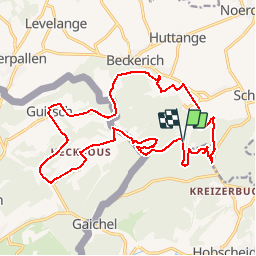
Tour Mountainbike von 19,1 km verfügbar auf Unbekannt, Kanton Redingen, Beckerich. Diese Tour wird von Visit Luxembourg vorgeschlagen.
Beschreibung
Parcours de VTT 18 km de Beckerich à Hovelange, Schweich, Hobscheid, Leitrange, Heckbus, Gaichel, Guirsch (Arlon) et retour
Ort
Land:
Luxembourg
Region :
Unbekannt
Abteilung/Provinz :
Kanton Redingen
Kommune :
Beckerich
Standort:
Unknown
Gehen Sie:(Dec)
Gehen Sie:(UTM)
709030 ; 5510702 (31U) N.
Kommentare
Touren in der Umgebung
![Tour Wandern Arel - Clairefontaine - Circuit Natura 2000, des sites qui valent le détour - Lx15 - Photo](https://media.geolcdn.com/t/375/260/ext.jpg?maxdim=2&url=https%3A%2F%2Fservices.sitytrail.com%2FGeolivesWS%2FDownloadMedia.ashx%3FTrailID%3D333331%26Media%3D011bab6f-c149-41bf-be76-696578f9f696.JPG)
![Wandern Wandern](https://static1.geolcdn.com/sitytour/trail-icons/101.png)
Clairefontaine - Circuit Natura 2000, des sites qui valent le détour - Lx15
Wandern
Einfach
(2)
Arel,
Wallonien,
Luxemburg,
Belgium
![](/images/other/stat-length.png)
4,1 km | 5,3 km-effort
1h 11min
![](https://static1.geolcdn.com/siteimages/upload/files/16400158638029165_repeat_loop_refresh_sync_direction_icon.png)
Ja
![Tour Wandern Arel - Guirsch, vallée des moulins - Photo](https://media.geolcdn.com/t/375/260/ext.jpg?maxdim=2&url=https%3A%2F%2Fservices.sitytrail.com%2FGeolivesWS%2FDownloadMedia.ashx%3FTrailID%3D462490%26Media%3Dfix__20150822151852.jpg)
![Wandern Wandern](https://static1.geolcdn.com/sitytour/trail-icons/101.png)
Guirsch, vallée des moulins
Wandern
Sehr leicht
(1)
Arel,
Wallonien,
Luxemburg,
Belgium
![](/images/other/stat-length.png)
5,8 km | 7,2 km-effort
1h 33min
![](https://static1.geolcdn.com/siteimages/upload/files/16400158638029165_repeat_loop_refresh_sync_direction_icon.png)
Nein
![Tour Wandern Habscht - Tunnel Tour - Photo](https://media.geolcdn.com/t/375/260/82720245-2ef9-4a0b-a9f7-0bd828756b2c.jpg&format=jpg&maxdim=2)
![Wandern Wandern](https://static1.geolcdn.com/sitytour/trail-icons/101.png)
Tunnel Tour
Wandern
Medium
(1)
Habscht,
Unbekannt,
Kanton Kapellen,
Luxembourg
![](/images/other/stat-length.png)
4,2 km | 6,2 km-effort
1h 24min
![](https://static1.geolcdn.com/siteimages/upload/files/16400158638029165_repeat_loop_refresh_sync_direction_icon.png)
Ja
![Tour Wandern Arel - RF-Lu-15 - Une randonnée (trans)frontalière : Clairefontaine - Photo](https://media.geolcdn.com/t/375/260/ext.jpg?maxdim=2&url=https%3A%2F%2Fstatic1.geolcdn.com%2Fsiteimages%2Fupload%2Ffiles%2F1553511878bg_sport_marche.png)
![Wandern Wandern](https://static1.geolcdn.com/sitytour/trail-icons/101.png)
RF-Lu-15 - Une randonnée (trans)frontalière : Clairefontaine
Wandern
Sehr leicht
(3)
Arel,
Wallonien,
Luxemburg,
Belgium
![](/images/other/stat-length.png)
11,1 km | 14,7 km-effort
3h 11min
![](https://static1.geolcdn.com/siteimages/upload/files/16400158638029165_repeat_loop_refresh_sync_direction_icon.png)
Ja
![Tour Zu Fuß Arel - N° 8 - Waltzing-Eischen, balade belgo-luxembourgeoise - Photo](https://media.geolcdn.com/t/375/260/b0eed337-7084-4191-bc62-985346659136.jpeg&format=jpg&maxdim=2)
![Zu Fuß Zu Fuß](https://static1.geolcdn.com/sitytour/trail-icons/100.png)
N° 8 - Waltzing-Eischen, balade belgo-luxembourgeoise
Zu Fuß
Einfach
Arel,
Wallonien,
Luxemburg,
Belgium
![](/images/other/stat-length.png)
10,3 km | 13 km-effort
2h 57min
![](https://static1.geolcdn.com/siteimages/upload/files/16400158638029165_repeat_loop_refresh_sync_direction_icon.png)
Ja
![Tour Zu Fuß Arel - N° 10 - Clairefontaine : Ermesinde - Photo](https://media.geolcdn.com/t/375/260/06dc8e88-1074-4dc8-92e2-176257711686.jpeg&format=jpg&maxdim=2)
![Zu Fuß Zu Fuß](https://static1.geolcdn.com/sitytour/trail-icons/100.png)
N° 10 - Clairefontaine : Ermesinde
Zu Fuß
Einfach
Arel,
Wallonien,
Luxemburg,
Belgium
![](/images/other/stat-length.png)
4 km | 5,1 km-effort
1h 9min
![](https://static1.geolcdn.com/siteimages/upload/files/16400158638029165_repeat_loop_refresh_sync_direction_icon.png)
Ja
![Tour Zu Fuß Arel - N° 7 - Clairefontaine - L'Eisch - Photo](https://media.geolcdn.com/t/375/260/06dc8e88-1074-4dc8-92e2-176257711686.jpeg&format=jpg&maxdim=2)
![Zu Fuß Zu Fuß](https://static1.geolcdn.com/sitytour/trail-icons/100.png)
N° 7 - Clairefontaine - L'Eisch
Zu Fuß
Einfach
Arel,
Wallonien,
Luxemburg,
Belgium
![](/images/other/stat-length.png)
4,1 km | 5,4 km-effort
1h 13min
![](https://static1.geolcdn.com/siteimages/upload/files/16400158638029165_repeat_loop_refresh_sync_direction_icon.png)
Ja
![Tour Zu Fuß Arel - N° 9 - Guirsch - Village classé - Photo](https://media.geolcdn.com/t/375/260/410f3ad8-b28a-47ec-9524-4613e0bb8c90.jpeg&format=jpg&maxdim=2)
![Zu Fuß Zu Fuß](https://static1.geolcdn.com/sitytour/trail-icons/100.png)
N° 9 - Guirsch - Village classé
Zu Fuß
Einfach
Arel,
Wallonien,
Luxemburg,
Belgium
![](/images/other/stat-length.png)
6,5 km | 8,8 km-effort
1h 59min
![](https://static1.geolcdn.com/siteimages/upload/files/16400158638029165_repeat_loop_refresh_sync_direction_icon.png)
Ja
![Tour Zu Fuß Beckerich - Oberpallen Wanderpfad / FB BL - Photo](https://media.geolcdn.com/t/375/260/c3bbc76d-9b9e-4cef-94e3-b9ff01ba29f2.jpeg&format=jpg&maxdim=2)
![Zu Fuß Zu Fuß](https://static1.geolcdn.com/sitytour/trail-icons/100.png)
Oberpallen Wanderpfad / FB BL
Zu Fuß
Einfach
(1)
Beckerich,
Unbekannt,
Kanton Redingen,
Luxembourg
![](/images/other/stat-length.png)
8,2 km | 9,8 km-effort
2h 13min
![](https://static1.geolcdn.com/siteimages/upload/files/16400158638029165_repeat_loop_refresh_sync_direction_icon.png)
Ja
1ere utilisation, pronto