![](/images/other/stat-length.png)
![Tour Wandern Marseille - Campage Pastré - Marseilleveyre (B/510/9.5/15) - Photo](https://media.geolcdn.com/t/1900/400/ext.pjpeg?maxdim=2&url=https%3A%2F%2Fstatic1.geolcdn.com%2Fsiteimages%2Fupload%2Ffiles%2F1553511878bg_sport_marche.png)
Campage Pastré - Marseilleveyre (B/510/9.5/15)
lhags
Benutzer
![Länge](/images/other/stat-length.png)
Länge
9,4 km
![Maximale Höhe](https://static1.geolcdn.com/siteimages/upload/files/1508320355ic_sort_altitude_max_24dp.png)
Maximale Höhe
417 m
![Positive Höhendifferenz](https://static1.geolcdn.com/siteimages/upload/files/1508320355ic_sort_den_pos_24dp.png)
Positive Höhendifferenz
485 m
![Km-Effort](/images/other/stat-length.png)
Km-Effort
15,9 km
![Min. Höhe](https://static1.geolcdn.com/siteimages/upload/files/1508320355ic_sort_altitude_min_24dp.png)
Min. Höhe
16 m
![Negative Höhendifferenz](https://static1.geolcdn.com/siteimages/upload/files/1508320355ic_sort_den_neg_24dp.png)
Negative Höhendifferenz
482 m
![Boucle](https://static1.geolcdn.com/siteimages/upload/files/16400158638029165_repeat_loop_refresh_sync_direction_icon.png)
Boucle
Ja
Erstellungsdatum :
2014-12-10 00:00:00.0
Letzte Änderung :
2014-12-10 00:00:00.0
![Wandern](https://static1.geolcdn.com/sitytour/trail-icons/101.png)
3h10
Schwierigkeit : Medium
![Scannen Sie diesen QR-Code, um die Tour in der SityTrail-Anwendung zu öffnen](https://capi.geolives.com/qq0zvz2zws4bq2lad0pu/sitytour/trails/199264/qr.png?size=200)
Kostenlosegpshiking-Anwendung
Über SityTrail
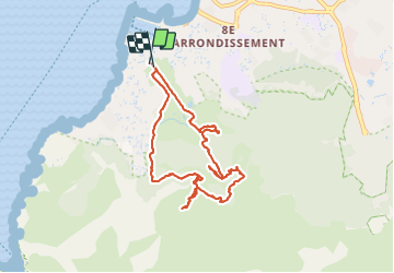
Tour Wandern von 9,4 km verfügbar auf Provence-Alpes-Côte d'Azur, Bouches-du-Rhône, Marseille. Diese Tour wird von lhags vorgeschlagen.
Beschreibung
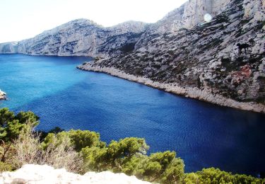
Sommet de Marseilleveyre par la campagne Pastré.
Bien suivre le balisage dans les passages des "étages"
Attention, la boucle derrière le château ne sert à rien :-)
(B: Boucle / Dénivelé: 510m / Distance : 9,5 Km / Coeff Difficulté : 15)
Ort
Land:
France
Region :
Provence-Alpes-Côte d'Azur
Abteilung/Provinz :
Bouches-du-Rhône
Kommune :
Marseille
Standort:
8e Arrondissement
Gehen Sie:(Dec)
Gehen Sie:(UTM)
692145 ; 4790178 (31T) N.
Kommentare
Touren in der Umgebung
![Tour Mountainbike Marseille - OR-6270829--Marseille:Trilogie des Calanques - Photo](https://media.geolcdn.com/t/375/260/37b85b5c-5918-4ab9-a017-9d4bcff1fa49.jpg&format=jpg&maxdim=2)
![Mountainbike Mountainbike](https://static1.geolcdn.com/sitytour/trail-icons/202.png)
OR-6270829--Marseille:Trilogie des Calanques
Mountainbike
Schwierig
(1)
Marseille,
Provence-Alpes-Côte d'Azur,
Bouches-du-Rhône,
France
![](/images/other/stat-length.png)
28 km | 35 km-effort
3h 30min
![](https://static1.geolcdn.com/siteimages/upload/files/16400158638029165_repeat_loop_refresh_sync_direction_icon.png)
Ja
![Tour Wandern Marseille - CE calanques morgiou et sugiton - Photo](https://media.geolcdn.com/t/375/260/f27f8a0f-14e3-4522-b1cc-023c0fb4d9dc.jpg&format=jpg&maxdim=2)
![Wandern Wandern](https://static1.geolcdn.com/sitytour/trail-icons/101.png)
CE calanques morgiou et sugiton
Wandern
Medium
(1)
Marseille,
Provence-Alpes-Côte d'Azur,
Bouches-du-Rhône,
France
![](/images/other/stat-length.png)
12,7 km | 19,3 km-effort
6h 33min
![](https://static1.geolcdn.com/siteimages/upload/files/16400158638029165_repeat_loop_refresh_sync_direction_icon.png)
Nein
![Tour Wandern Marseille - Marseilleveyre - Photo](https://media.geolcdn.com/t/375/260/1c6dd8e4-fc3d-455d-ab0a-aecb3f4e28f3.jpg&format=jpg&maxdim=2)
![Wandern Wandern](https://static1.geolcdn.com/sitytour/trail-icons/101.png)
Marseilleveyre
Wandern
Sehr schwierig
Marseille,
Provence-Alpes-Côte d'Azur,
Bouches-du-Rhône,
France
![](/images/other/stat-length.png)
13,8 km | 23 km-effort
6h 7min
![](https://static1.geolcdn.com/siteimages/upload/files/16400158638029165_repeat_loop_refresh_sync_direction_icon.png)
Ja
![Tour Zu Fuß Marseille - FR-6 - Photo](https://media.geolcdn.com/t/375/260/4cd62a7f-c9ca-4a0b-a61b-53cee5136735.jpeg&format=jpg&maxdim=2)
![Zu Fuß Zu Fuß](https://static1.geolcdn.com/sitytour/trail-icons/100.png)
FR-6
Zu Fuß
Einfach
Marseille,
Provence-Alpes-Côte d'Azur,
Bouches-du-Rhône,
France
![](/images/other/stat-length.png)
7,7 km | 13,3 km-effort
3h 1min
![](https://static1.geolcdn.com/siteimages/upload/files/16400158638029165_repeat_loop_refresh_sync_direction_icon.png)
Nein
![Tour Zu Fuß Marseille - FR-5 - Photo](https://media.geolcdn.com/t/375/260/16e34afb-89c4-4f3e-815d-2c5b36f21175.jpeg&format=jpg&maxdim=2)
![Zu Fuß Zu Fuß](https://static1.geolcdn.com/sitytour/trail-icons/100.png)
FR-5
Zu Fuß
Einfach
Marseille,
Provence-Alpes-Côte d'Azur,
Bouches-du-Rhône,
France
![](/images/other/stat-length.png)
4,8 km | 8,7 km-effort
1h 58min
![](https://static1.geolcdn.com/siteimages/upload/files/16400158638029165_repeat_loop_refresh_sync_direction_icon.png)
Nein
![Tour Zu Fuß Marseille - FR-4 - Photo](https://media.geolcdn.com/t/375/260/95b4ab9b-15fa-4206-9283-bece755bce28.jpeg&format=jpg&maxdim=2)
![Zu Fuß Zu Fuß](https://static1.geolcdn.com/sitytour/trail-icons/100.png)
FR-4
Zu Fuß
Einfach
Marseille,
Provence-Alpes-Côte d'Azur,
Bouches-du-Rhône,
France
![](/images/other/stat-length.png)
4 km | 7,3 km-effort
1h 39min
![](https://static1.geolcdn.com/siteimages/upload/files/16400158638029165_repeat_loop_refresh_sync_direction_icon.png)
Nein
![Tour Zu Fuß Marseille - FR-1 - Photo](https://media.geolcdn.com/t/375/260/bc3bf1c1-4e6d-4ecd-b741-b7754447ebb3.jpeg&format=jpg&maxdim=2)
![Zu Fuß Zu Fuß](https://static1.geolcdn.com/sitytour/trail-icons/100.png)
FR-1
Zu Fuß
Einfach
Marseille,
Provence-Alpes-Côte d'Azur,
Bouches-du-Rhône,
France
![](/images/other/stat-length.png)
3,4 km | 5,8 km-effort
1h 18min
![](https://static1.geolcdn.com/siteimages/upload/files/16400158638029165_repeat_loop_refresh_sync_direction_icon.png)
Nein
![Tour Zu Fuß Marseille - FR-1 - Photo](https://media.geolcdn.com/t/375/260/99184d8a-cb78-4a50-b5ed-c50326639dce.jpeg&format=jpg&maxdim=2)
![Zu Fuß Zu Fuß](https://static1.geolcdn.com/sitytour/trail-icons/100.png)
FR-1
Zu Fuß
Einfach
(1)
Marseille,
Provence-Alpes-Côte d'Azur,
Bouches-du-Rhône,
France
![](/images/other/stat-length.png)
7,2 km | 12,8 km-effort
2h 54min
![](https://static1.geolcdn.com/siteimages/upload/files/16400158638029165_repeat_loop_refresh_sync_direction_icon.png)
Nein
![Tour Zu Fuß Marseille - FR-1 - Photo](https://media.geolcdn.com/t/375/260/bc3bf1c1-4e6d-4ecd-b741-b7754447ebb3.jpeg&format=jpg&maxdim=2)
![Zu Fuß Zu Fuß](https://static1.geolcdn.com/sitytour/trail-icons/100.png)
FR-1
Zu Fuß
Einfach
Marseille,
Provence-Alpes-Côte d'Azur,
Bouches-du-Rhône,
France
![](/images/other/stat-length.png)
3 km | 7,1 km-effort
1h 37min
![](https://static1.geolcdn.com/siteimages/upload/files/16400158638029165_repeat_loop_refresh_sync_direction_icon.png)
Nein