![](/images/other/stat-length.png)
![Tour Wandern Zutendaal - Zutendaal - Photo](https://media.geolcdn.com/t/1900/400/ext.pjpeg?maxdim=2&url=https%3A%2F%2Fstatic1.geolcdn.com%2Fsiteimages%2Fupload%2Ffiles%2F1553511878bg_sport_marche.png)
Zutendaal
flip96
Benutzer
![Länge](/images/other/stat-length.png)
Länge
23 km
![Maximale Höhe](https://static1.geolcdn.com/siteimages/upload/files/1508320355ic_sort_altitude_max_24dp.png)
Maximale Höhe
106 m
![Positive Höhendifferenz](https://static1.geolcdn.com/siteimages/upload/files/1508320355ic_sort_den_pos_24dp.png)
Positive Höhendifferenz
244 m
![Km-Effort](/images/other/stat-length.png)
Km-Effort
26 km
![Min. Höhe](https://static1.geolcdn.com/siteimages/upload/files/1508320355ic_sort_altitude_min_24dp.png)
Min. Höhe
68 m
![Negative Höhendifferenz](https://static1.geolcdn.com/siteimages/upload/files/1508320355ic_sort_den_neg_24dp.png)
Negative Höhendifferenz
243 m
![Boucle](https://static1.geolcdn.com/siteimages/upload/files/16400158638029165_repeat_loop_refresh_sync_direction_icon.png)
Boucle
Ja
Erstellungsdatum :
2014-12-10 00:00:00.0
Letzte Änderung :
2014-12-10 00:00:00.0
![Wandern](https://static1.geolcdn.com/sitytour/trail-icons/101.png)
5h00
Schwierigkeit : Einfach
![Scannen Sie diesen QR-Code, um die Tour in der SityTrail-Anwendung zu öffnen](https://capi.geolives.com/qq0zvz2zws4bq2lad0pu/sitytour/trails/198267/qr.png?size=200)
Kostenlosegpshiking-Anwendung
Über SityTrail
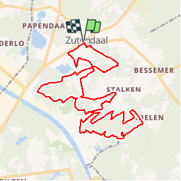
Tour Wandern von 23 km verfügbar auf Flandern, Limburg, Zutendaal. Diese Tour wird von flip96 vorgeschlagen.
Beschreibung
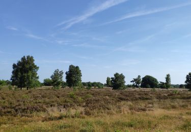
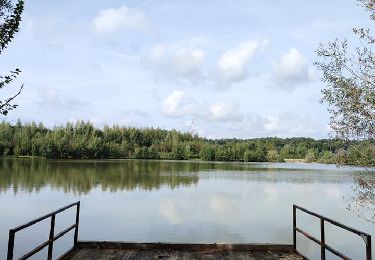
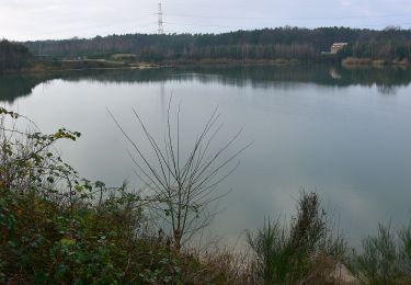
Rondwandeling vanaf Vijverplein in Zutendaal.
Eenvoudige, vlakke wandeling.
Jammer dat alle watertjes privé-eigendom zijn.
Opmerkingen? flip96@home.nl
Ort
Land:
Belgium
Region :
Flandern
Abteilung/Provinz :
Limburg
Kommune :
Zutendaal
Standort:
Zutendaal
Gehen Sie:(Dec)
Gehen Sie:(UTM)
680655 ; 5645331 (31U) N.
Kommentare
Touren in der Umgebung
![Tour Fahrrad Genk - Verrassende vergezichten - Photo](https://media.geolcdn.com/t/375/260/31227550-2d1e-474d-a121-b2a405d0d5b9.jpg&format=jpg&maxdim=2)
![Fahrrad Fahrrad](https://static1.geolcdn.com/sitytour/trail-icons/200.png)
Verrassende vergezichten
Fahrrad
Sehr leicht
(1)
Genk,
Flandern,
Limburg,
Belgium
![](/images/other/stat-length.png)
56 km | 63 km-effort
3h 0min
![](https://static1.geolcdn.com/siteimages/upload/files/16400158638029165_repeat_loop_refresh_sync_direction_icon.png)
Ja
![Tour Wandern Zutendaal - Promenade de Papendaalheide - Photo](https://media.geolcdn.com/t/375/260/4e56217a-c7d6-4b98-8c3a-5cd7f84ac60f.jpg&format=jpg&maxdim=2)
![Wandern Wandern](https://static1.geolcdn.com/sitytour/trail-icons/101.png)
Promenade de Papendaalheide
Wandern
Einfach
Zutendaal,
Flandern,
Limburg,
Belgium
![](/images/other/stat-length.png)
4,9 km | 5,5 km-effort
1h 15min
![](https://static1.geolcdn.com/siteimages/upload/files/16400158638029165_repeat_loop_refresh_sync_direction_icon.png)
Ja
![Tour Wandern Genk - Promenade de Kattevennen - Photo](https://media.geolcdn.com/t/375/260/89f9be8b-be87-4190-884b-d7d87ca5b9ad.jpg&format=jpg&maxdim=2)
![Wandern Wandern](https://static1.geolcdn.com/sitytour/trail-icons/101.png)
Promenade de Kattevennen
Wandern
Medium
(1)
Genk,
Flandern,
Limburg,
Belgium
![](/images/other/stat-length.png)
7,4 km | 8,3 km-effort
1h 53min
![](https://static1.geolcdn.com/siteimages/upload/files/16400158638029165_repeat_loop_refresh_sync_direction_icon.png)
Ja
![Tour Zu Fuß Zutendaal - Papendaalheide Groene rechthoek - Photo](https://media.geolcdn.com/t/375/260/61aba794-7888-4dc3-bb68-e186310dacfe.jpeg&format=jpg&maxdim=2)
![Zu Fuß Zu Fuß](https://static1.geolcdn.com/sitytour/trail-icons/100.png)
Papendaalheide Groene rechthoek
Zu Fuß
Einfach
Zutendaal,
Flandern,
Limburg,
Belgium
![](/images/other/stat-length.png)
5,1 km | 5,8 km-effort
1h 18min
![](https://static1.geolcdn.com/siteimages/upload/files/16400158638029165_repeat_loop_refresh_sync_direction_icon.png)
Ja
![Tour Zu Fuß Zutendaal - Lieteberg - Papendaalheide Rode driehoek - Photo](https://media.geolcdn.com/t/375/260/4351c275-94e5-4a21-8486-701fab6129e8.jpeg&format=jpg&maxdim=2)
![Zu Fuß Zu Fuß](https://static1.geolcdn.com/sitytour/trail-icons/100.png)
Lieteberg - Papendaalheide Rode driehoek
Zu Fuß
Einfach
Zutendaal,
Flandern,
Limburg,
Belgium
![](/images/other/stat-length.png)
10,8 km | 12,4 km-effort
2h 49min
![](https://static1.geolcdn.com/siteimages/upload/files/16400158638029165_repeat_loop_refresh_sync_direction_icon.png)
Ja
![Tour Zu Fuß Genk - Kattevennen - Papendaalheide - Sledderlo Gele zeshoek - Photo](https://media.geolcdn.com/t/375/260/60e09a2e-7d20-45c6-a897-1d577945a69a.jpeg&format=jpg&maxdim=2)
![Zu Fuß Zu Fuß](https://static1.geolcdn.com/sitytour/trail-icons/100.png)
Kattevennen - Papendaalheide - Sledderlo Gele zeshoek
Zu Fuß
Einfach
Genk,
Flandern,
Limburg,
Belgium
![](/images/other/stat-length.png)
12 km | 13,6 km-effort
3h 5min
![](https://static1.geolcdn.com/siteimages/upload/files/16400158638029165_repeat_loop_refresh_sync_direction_icon.png)
Ja
![Tour Zu Fuß Genk - Zillebos blauwe ruit - Photo](https://media.geolcdn.com/t/375/260/6925453e-2323-4e41-8380-50ced4fee93a.jpeg&format=jpg&maxdim=2)
![Zu Fuß Zu Fuß](https://static1.geolcdn.com/sitytour/trail-icons/100.png)
Zillebos blauwe ruit
Zu Fuß
Einfach
Genk,
Flandern,
Limburg,
Belgium
![](/images/other/stat-length.png)
4,2 km | 4,9 km-effort
1h 7min
![](https://static1.geolcdn.com/siteimages/upload/files/16400158638029165_repeat_loop_refresh_sync_direction_icon.png)
Ja
![Tour Zu Fuß Genk - Zillebos rode driehoek - Photo](https://media.geolcdn.com/t/375/260/6925453e-2323-4e41-8380-50ced4fee93a.jpeg&format=jpg&maxdim=2)
![Zu Fuß Zu Fuß](https://static1.geolcdn.com/sitytour/trail-icons/100.png)
Zillebos rode driehoek
Zu Fuß
Einfach
Genk,
Flandern,
Limburg,
Belgium
![](/images/other/stat-length.png)
5,5 km | 6,4 km-effort
1h 27min
![](https://static1.geolcdn.com/siteimages/upload/files/16400158638029165_repeat_loop_refresh_sync_direction_icon.png)
Ja
![Tour Zu Fuß Bilzen - Hoefaert Rode driehoek - Photo](https://media.geolcdn.com/t/375/260/5b2ce394-fffe-4e26-87f6-f3ba328634d3.jpeg&format=jpg&maxdim=2)
![Zu Fuß Zu Fuß](https://static1.geolcdn.com/sitytour/trail-icons/100.png)
Hoefaert Rode driehoek
Zu Fuß
Einfach
Bilzen,
Flandern,
Limburg,
Belgium
![](/images/other/stat-length.png)
9,5 km | 10,7 km-effort
2h 26min
![](https://static1.geolcdn.com/siteimages/upload/files/16400158638029165_repeat_loop_refresh_sync_direction_icon.png)
Ja