![](/images/other/stat-length.png)
![Tour Andere Aktivitäten Glarus - GL / ennenda - murgsee - spitzmeilen - mels - tag 1 - Photo](https://media.geolcdn.com/t/1900/400/ext.pjpeg?maxdim=2&url=https%3A%2F%2Fstatic1.geolcdn.com%2Fsiteimages%2Fupload%2Ffiles%2F1545311037marcheuse_200dpi.jpg)
GL / ennenda - murgsee - spitzmeilen - mels - tag 1
denisewanderige
Benutzer
![Länge](/images/other/stat-length.png)
Länge
7,6 km
![Maximale Höhe](https://static1.geolcdn.com/siteimages/upload/files/1508320355ic_sort_altitude_max_24dp.png)
Maximale Höhe
2363 m
![Positive Höhendifferenz](https://static1.geolcdn.com/siteimages/upload/files/1508320355ic_sort_den_pos_24dp.png)
Positive Höhendifferenz
926 m
![Km-Effort](/images/other/stat-length.png)
Km-Effort
18,7 km
![Min. Höhe](https://static1.geolcdn.com/siteimages/upload/files/1508320355ic_sort_altitude_min_24dp.png)
Min. Höhe
1442 m
![Negative Höhendifferenz](https://static1.geolcdn.com/siteimages/upload/files/1508320355ic_sort_den_neg_24dp.png)
Negative Höhendifferenz
549 m
![Boucle](https://static1.geolcdn.com/siteimages/upload/files/16400158638029165_repeat_loop_refresh_sync_direction_icon.png)
Boucle
Nein
Erstellungsdatum :
2014-12-11 00:00:00.0
Letzte Änderung :
2014-12-11 00:00:00.0
![Andere Aktivitäten](https://static1.geolcdn.com/sitytour/trail-icons/900.png)
--
Schwierigkeit : Unbekannt
![Scannen Sie diesen QR-Code, um die Tour in der SityTrail-Anwendung zu öffnen](https://capi.geolives.com/qq0zvz2zws4bq2lad0pu/sitytour/trails/19419/qr.png?size=200)
Kostenlosegpshiking-Anwendung
Über SityTrail
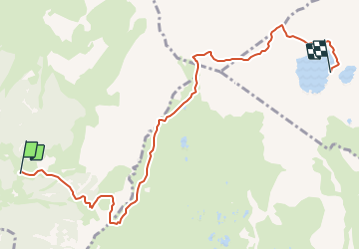
Tour Andere Aktivitäten von 7,6 km verfügbar auf Glarus, Unbekannt, Glarus. Diese Tour wird von denisewanderige vorgeschlagen.
Beschreibung
1. tag:
bärebode - heustockfurggel - schwarzstöckli - murgseefurggel - murgseehütte
Details (Wanderbeschrieb, Fotos, Dauer, Links, usw.) siehe unter:
http://www.wanderige.ch/wanderige_toure/2003-2005/ennenda_1/ennenda_eis.htm
Ort
Land:
Switzerland
Region :
Glarus
Abteilung/Provinz :
Unbekannt
Kommune :
Glarus
Standort:
Unknown
Gehen Sie:(Dec)
Gehen Sie:(UTM)
507872 ; 5208188 (32T) N.
Kommentare
Touren in der Umgebung
![Tour Zu Fuß Glarus Süd - Ober-Sool - fixme - Photo](https://media.geolcdn.com/t/375/260/6acf3b68-4df6-4014-921f-5cbcee916b82.jpeg&format=jpg&maxdim=2)
![Zu Fuß Zu Fuß](https://static1.geolcdn.com/sitytour/trail-icons/100.png)
Ober-Sool - fixme
Zu Fuß
Einfach
Glarus Süd,
Glarus,
Unbekannt,
Switzerland
![](/images/other/stat-length.png)
4,3 km | 7,2 km-effort
1h 37min
![](https://static1.geolcdn.com/siteimages/upload/files/16400158638029165_repeat_loop_refresh_sync_direction_icon.png)
Nein
![Tour Zu Fuß Glarus Süd - Ober-Sool - Gheist - Photo](https://media.geolcdn.com/t/375/260/6acf3b68-4df6-4014-921f-5cbcee916b82.jpeg&format=jpg&maxdim=2)
![Zu Fuß Zu Fuß](https://static1.geolcdn.com/sitytour/trail-icons/100.png)
Ober-Sool - Gheist
Zu Fuß
Einfach
Glarus Süd,
Glarus,
Unbekannt,
Switzerland
![](/images/other/stat-length.png)
4,6 km | 11,6 km-effort
2h 37min
![](https://static1.geolcdn.com/siteimages/upload/files/16400158638029165_repeat_loop_refresh_sync_direction_icon.png)
Nein
![Tour Zu Fuß Glarus - Äugsten - Passhöhe - Photo](https://media.geolcdn.com/t/375/260/64f84f56-1cff-404a-ba7d-498ea23f644b.jpeg&format=jpg&maxdim=2)
![Zu Fuß Zu Fuß](https://static1.geolcdn.com/sitytour/trail-icons/100.png)
Äugsten - Passhöhe
Zu Fuß
Einfach
Glarus,
Glarus,
Unbekannt,
Switzerland
![](/images/other/stat-length.png)
4,9 km | 13,5 km-effort
3h 4min
![](https://static1.geolcdn.com/siteimages/upload/files/16400158638029165_repeat_loop_refresh_sync_direction_icon.png)
Nein
![Tour Zu Fuß Glarus Süd - Mettlen - Soolsteg - Photo](https://media.geolcdn.com/t/375/260/bd08ec3f-0540-4e6e-a5fe-27561de9e2bf.jpeg&format=jpg&maxdim=2)
![Zu Fuß Zu Fuß](https://static1.geolcdn.com/sitytour/trail-icons/100.png)
Mettlen - Soolsteg
Zu Fuß
Einfach
Glarus Süd,
Glarus,
Unbekannt,
Switzerland
![](/images/other/stat-length.png)
3,3 km | 4,4 km-effort
1h 0min
![](https://static1.geolcdn.com/siteimages/upload/files/16400158638029165_repeat_loop_refresh_sync_direction_icon.png)
Nein
![Tour Zu Fuß Glarus Süd - Schwändi Schulhaus-Yenstock - Photo](https://media.geolcdn.com/t/375/260/b0a658d8-8adb-4e8f-b92f-0e4e6f8cd258.jpeg&format=jpg&maxdim=2)
![Zu Fuß Zu Fuß](https://static1.geolcdn.com/sitytour/trail-icons/100.png)
Schwändi Schulhaus-Yenstock
Zu Fuß
Medium
Glarus Süd,
Glarus,
Unbekannt,
Switzerland
![](/images/other/stat-length.png)
7 km | 21 km-effort
4h 42min
![](https://static1.geolcdn.com/siteimages/upload/files/16400158638029165_repeat_loop_refresh_sync_direction_icon.png)
Nein
![Tour Zu Fuß Glarus - Bitzigen-Stelliwaldhütte - Photo](https://media.geolcdn.com/t/375/260/ext.jpg?maxdim=2&url=https%3A%2F%2Fstatic1.geolcdn.com%2Fsiteimages%2Fupload%2Ffiles%2F1545311037marcheuse_200dpi.jpg)
![Zu Fuß Zu Fuß](https://static1.geolcdn.com/sitytour/trail-icons/100.png)
Bitzigen-Stelliwaldhütte
Zu Fuß
Einfach
Glarus,
Glarus,
Unbekannt,
Switzerland
![](/images/other/stat-length.png)
3,7 km | 8 km-effort
1h 49min
![](https://static1.geolcdn.com/siteimages/upload/files/16400158638029165_repeat_loop_refresh_sync_direction_icon.png)
Nein
![Tour Mountainbike Glarus - passKlausen1 - Photo](https://media.geolcdn.com/t/375/260/ext.jpg?maxdim=2&url=https%3A%2F%2Fstatic1.geolcdn.com%2Fsiteimages%2Fupload%2Ffiles%2F1524743154velo.jpg)
![Mountainbike Mountainbike](https://static1.geolcdn.com/sitytour/trail-icons/202.png)
passKlausen1
Mountainbike
Sehr leicht
Glarus,
Glarus,
Unbekannt,
Switzerland
![](/images/other/stat-length.png)
39 km | 57 km-effort
Unbekannt
![](https://static1.geolcdn.com/siteimages/upload/files/16400158638029165_repeat_loop_refresh_sync_direction_icon.png)
Nein
![Tour Wandern Glarus - sf09_e7a - Photo](https://media.geolcdn.com/t/375/260/ext.jpg?maxdim=2&url=https%3A%2F%2Fstatic1.geolcdn.com%2Fsiteimages%2Fupload%2Ffiles%2F1553511878bg_sport_marche.png)
![Wandern Wandern](https://static1.geolcdn.com/sitytour/trail-icons/101.png)
sf09_e7a
Wandern
Sehr leicht
Glarus,
Glarus,
Unbekannt,
Switzerland
![](/images/other/stat-length.png)
12,6 km | 18,2 km-effort
3h 35min
![](https://static1.geolcdn.com/siteimages/upload/files/16400158638029165_repeat_loop_refresh_sync_direction_icon.png)
Nein
![Tour Wandern Glarus Süd - test_murgl - Photo](https://media.geolcdn.com/t/375/260/ext.jpg?maxdim=2&url=https%3A%2F%2Fstatic1.geolcdn.com%2Fsiteimages%2Fupload%2Ffiles%2F1553511878bg_sport_marche.png)
![Wandern Wandern](https://static1.geolcdn.com/sitytour/trail-icons/101.png)
test_murgl
Wandern
Sehr leicht
Glarus Süd,
Glarus,
Unbekannt,
Switzerland
![](/images/other/stat-length.png)
48 km | 125 km-effort
Unbekannt
![](https://static1.geolcdn.com/siteimages/upload/files/16400158638029165_repeat_loop_refresh_sync_direction_icon.png)
Nein