![](/images/other/stat-length.png)
![Tour Wandern PREMANON - Le Belvédère des Maquisards - Prémanon - Photo](https://media.geolcdn.com/t/1900/400/ext.pjpeg?maxdim=2&url=https%3A%2F%2Fservices.sitytrail.com%2FGeolivesWS%2FDownloadMedia.ashx%3FTrailID%3D191470%26Media%3D15062_5.jpg)
Le Belvédère des Maquisards - Prémanon
tracegps
Benutzer
![Länge](/images/other/stat-length.png)
![Maximale Höhe](https://static1.geolcdn.com/siteimages/upload/files/1508320355ic_sort_altitude_max_24dp.png)
![Positive Höhendifferenz](https://static1.geolcdn.com/siteimages/upload/files/1508320355ic_sort_den_pos_24dp.png)
![Km-Effort](/images/other/stat-length.png)
![Min. Höhe](https://static1.geolcdn.com/siteimages/upload/files/1508320355ic_sort_altitude_min_24dp.png)
![Negative Höhendifferenz](https://static1.geolcdn.com/siteimages/upload/files/1508320355ic_sort_den_neg_24dp.png)
![Boucle](https://static1.geolcdn.com/siteimages/upload/files/16400158638029165_repeat_loop_refresh_sync_direction_icon.png)
![Wandern](https://static1.geolcdn.com/sitytour/trail-icons/101.png)
2h00
Schwierigkeit : Medium
![Scannen Sie diesen QR-Code, um die Tour in der SityTrail-Anwendung zu öffnen](https://capi.geolives.com/qq0zvz2zws4bq2lad0pu/sitytour/trails/191470/qr.png?size=200)
Kostenlosegpshiking-Anwendung
Über SityTrail
Tour Wandern von 5,4 km verfügbar auf Burgund und Freigrafschaft, Jura. Diese Tour wird von tracegps vorgeschlagen.
Beschreibung
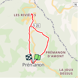
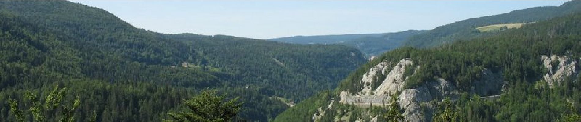
Au départ du centre village de Prémanon (à côte de l’arrêt de bus), prenez la direction Chez Jeankessis en suivant le balisage jaune. Suivez la route goudronnée sur 200m, puis quittez-la pour prendre à gauche le chemin en pierre qui descend. A partir de là suivez le balisage jaune. Par deux fois, traversez une route goudronnée et continuez tout droit pour récupérer le chemin empierré. L’itinéraire retombe de nouveau sur une route goudronnée, suivez-la sur quelques mètres et quittez-la dans le virage pour prendre le chemin en pierre sur la gauche. A Chez Jeankessis, continuez tout droit, direction Sur le Belvédère. Passez le carrefour Sur le Belvédère, le sentier descend jusqu’à la RD25. Longez-la sur la droite puis traversez-la avec prudence. Avancez jusqu’au belvédère et admirez le point de vue sur la haute-vallée de la Bienne, le Mont Fier et le massif du Risoux. La vallée de la Bienne est longue de 72 km, elle traverse le Haut-Jura puis se jette dans l’Ain. La Bienne a alimenté jusqu’à 53 usines hydro-motrices. Traversez de nouveau la route pour revenir sur vos pas jusqu’à Chez Jeankessis. A Chez Jeankessis, bifurquez à droite pour suivre le petit sentier direction Sur le Goulet. De nouveau, traversez la RD25 avec vigilance et prenez en face la route du Château le Pin. A Sur le Goulet, continuez à droite sur la route en direction de l’Abbé Barthelet sur 30m et prenez de nouveau à droite le chemin qui monte et retourne jusqu’au village de Prémanon.
Ort
Kommentare
Touren in der Umgebung
![Tour Fahrrad - Lac de Lamoura et Valserine - Prémanon - Photo](https://media.geolcdn.com/t/375/260/ext.jpg?maxdim=2&url=https%3A%2F%2Fservices.sitytrail.com%2FGeolivesWS%2FDownloadMedia.ashx%3FTrailID%3D317353%26Media%3D16571_5.jpg)
![Fahrrad Fahrrad](https://static1.geolcdn.com/sitytour/trail-icons/200.png)
Fahrrad
![](/images/other/stat-length.png)
![](https://static1.geolcdn.com/siteimages/upload/files/16400158638029165_repeat_loop_refresh_sync_direction_icon.png)
![Tour Wandern - Autour de Prémanon - Photo](https://media.geolcdn.com/t/375/260/ext.jpg?maxdim=2&url=https%3A%2F%2Fservices.sitytrail.com%2FGeolivesWS%2FDownloadMedia.ashx%3FTrailID%3D191468%26Media%3D15060_4.jpg)
![Wandern Wandern](https://static1.geolcdn.com/sitytour/trail-icons/101.png)
Wandern
![](/images/other/stat-length.png)
![](https://static1.geolcdn.com/siteimages/upload/files/16400158638029165_repeat_loop_refresh_sync_direction_icon.png)
![Tour Wandern Les Rousses - Le Noirmont - Les Rousses - Photo](https://media.geolcdn.com/t/375/260/ext.jpg?maxdim=2&url=https%3A%2F%2Fservices.sitytrail.com%2FGeolivesWS%2FDownloadMedia.ashx%3FTrailID%3D191437%26Media%3D15025_5.jpg)
![Wandern Wandern](https://static1.geolcdn.com/sitytour/trail-icons/101.png)
Wandern
![](/images/other/stat-length.png)
![](https://static1.geolcdn.com/siteimages/upload/files/16400158638029165_repeat_loop_refresh_sync_direction_icon.png)
![Tour Wandern Prémanon - dole1 - Photo](https://media.geolcdn.com/t/375/260/ext.jpg?maxdim=2&url=https%3A%2F%2Fservices.sitytrail.com%2FGeolivesWS%2FDownloadMedia.ashx%3FTrailID%3D136383%26Media%3D20120623131628.jpg)
![Wandern Wandern](https://static1.geolcdn.com/sitytour/trail-icons/101.png)
Wandern
![](/images/other/stat-length.png)
![](https://static1.geolcdn.com/siteimages/upload/files/16400158638029165_repeat_loop_refresh_sync_direction_icon.png)
![Tour Zu Fuß - Les Arcets - Photo](https://media.geolcdn.com/t/375/260/dbf9401a-4a63-43b8-9f8e-030f59772016.jpeg&format=jpg&maxdim=2)
![Zu Fuß Zu Fuß](https://static1.geolcdn.com/sitytour/trail-icons/100.png)
Zu Fuß
![](/images/other/stat-length.png)
![](https://static1.geolcdn.com/siteimages/upload/files/16400158638029165_repeat_loop_refresh_sync_direction_icon.png)
![Tour Wandern - Prémanon, Mont Fier - Photo](https://media.geolcdn.com/t/375/260/ext.jpg?maxdim=2&url=https%3A%2F%2Fstatic1.geolcdn.com%2Fsiteimages%2Fupload%2Ffiles%2F1553511878bg_sport_marche.png)
![Wandern Wandern](https://static1.geolcdn.com/sitytour/trail-icons/101.png)
Wandern
![](/images/other/stat-length.png)
![](https://static1.geolcdn.com/siteimages/upload/files/16400158638029165_repeat_loop_refresh_sync_direction_icon.png)
![Tour Schneeschuhwandern Les Rousses - Lac des Rousses - Photo](https://media.geolcdn.com/t/375/260/ext.jpg?maxdim=2&url=https%3A%2F%2Fstatic1.geolcdn.com%2Fsiteimages%2Fupload%2Ffiles%2F1524743153raquette.jpg)
![Schneeschuhwandern Schneeschuhwandern](https://static1.geolcdn.com/sitytour/trail-icons/504.png)
Schneeschuhwandern
![](/images/other/stat-length.png)
![](https://static1.geolcdn.com/siteimages/upload/files/16400158638029165_repeat_loop_refresh_sync_direction_icon.png)
![Tour Wandern Les Rousses - Noirmont et Creux du Croue - Photo](https://media.geolcdn.com/t/375/260/ext.jpg?maxdim=2&url=https%3A%2F%2Fstatic1.geolcdn.com%2Fsiteimages%2Fupload%2Ffiles%2F1553511878bg_sport_marche.png)
![Wandern Wandern](https://static1.geolcdn.com/sitytour/trail-icons/101.png)
Wandern
![](/images/other/stat-length.png)
![](https://static1.geolcdn.com/siteimages/upload/files/16400158638029165_repeat_loop_refresh_sync_direction_icon.png)
![Tour Wandern Prémanon - mon 8 de La DÔLE - Photo](https://media.geolcdn.com/t/375/260/19466126-b34e-426d-b8cd-3843abcfd6ed.jpg&format=jpg&maxdim=2)
![Wandern Wandern](https://static1.geolcdn.com/sitytour/trail-icons/101.png)
Wandern
![](/images/other/stat-length.png)
![](https://static1.geolcdn.com/siteimages/upload/files/16400158638029165_repeat_loop_refresh_sync_direction_icon.png)