![](/images/other/stat-length.png)
![Tour Wandern Botmeur - Roc'h Bichourel - Botmeur - Photo](https://media.geolcdn.com/t/1900/400/ext.pjpeg?maxdim=2&url=https%3A%2F%2Fservices.sitytrail.com%2FGeolivesWS%2FDownloadMedia.ashx%3FTrailID%3D191436%26Media%3D15024_3.jpg)
Roc'h Bichourel - Botmeur
tracegps
Benutzer
![Länge](/images/other/stat-length.png)
Länge
8,3 km
![Maximale Höhe](https://static1.geolcdn.com/siteimages/upload/files/1508320355ic_sort_altitude_max_24dp.png)
Maximale Höhe
358 m
![Positive Höhendifferenz](https://static1.geolcdn.com/siteimages/upload/files/1508320355ic_sort_den_pos_24dp.png)
Positive Höhendifferenz
146 m
![Km-Effort](/images/other/stat-length.png)
Km-Effort
10,2 km
![Min. Höhe](https://static1.geolcdn.com/siteimages/upload/files/1508320355ic_sort_altitude_min_24dp.png)
Min. Höhe
249 m
![Negative Höhendifferenz](https://static1.geolcdn.com/siteimages/upload/files/1508320355ic_sort_den_neg_24dp.png)
Negative Höhendifferenz
143 m
![Boucle](https://static1.geolcdn.com/siteimages/upload/files/16400158638029165_repeat_loop_refresh_sync_direction_icon.png)
Boucle
Ja
Erstellungsdatum :
2014-12-10 00:00:00.0
Letzte Änderung :
2014-12-10 00:00:00.0
![Wandern](https://static1.geolcdn.com/sitytour/trail-icons/101.png)
2h30
Schwierigkeit : Medium
![Scannen Sie diesen QR-Code, um die Tour in der SityTrail-Anwendung zu öffnen](https://capi.geolives.com/qq0zvz2zws4bq2lad0pu/sitytour/trails/191436/qr.png?size=200)
Kostenlosegpshiking-Anwendung
Über SityTrail
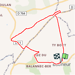
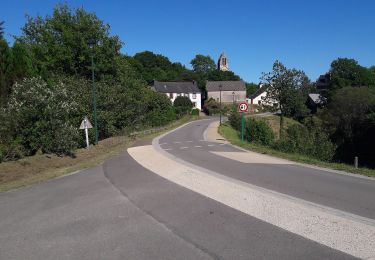
Tour Wandern von 8,3 km verfügbar auf Bretagne, Finistère, Botmeur. Diese Tour wird von tracegps vorgeschlagen.
Beschreibung
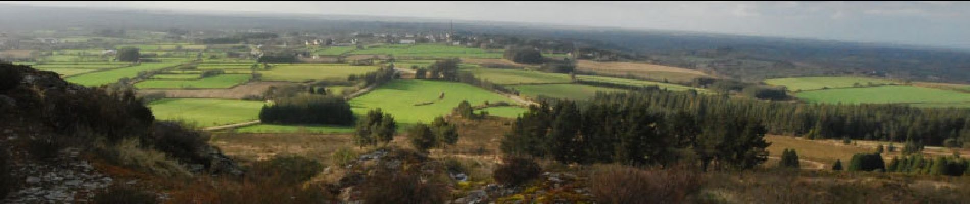
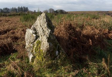
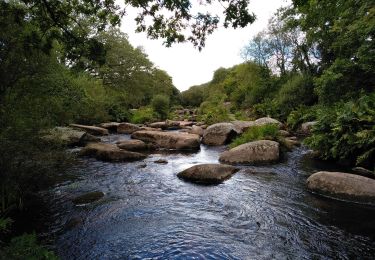
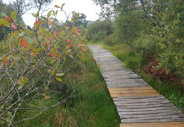
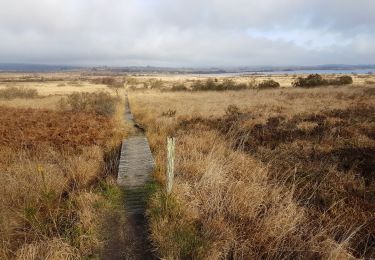
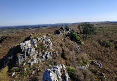
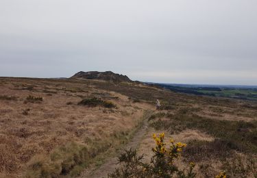
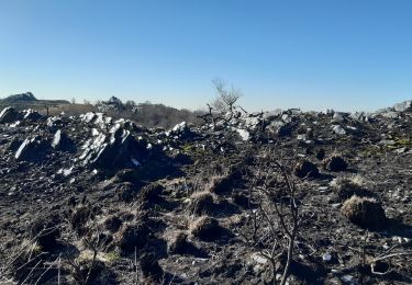
Un circuit au cœur des Monts d'Arrée. Au programme, les landes, les bruyères, les points de vues, les rochers de schiste...... pour cette rando.
Ort
Land:
France
Region :
Bretagne
Abteilung/Provinz :
Finistère
Kommune :
Botmeur
Standort:
Unknown
Gehen Sie:(Dec)
Gehen Sie:(UTM)
432190 ; 5359324 (30U) N.
Kommentare
Touren in der Umgebung
![Tour Zu Fuß Saint-Rivoal - Landes et Tourbières - Photo](https://media.geolcdn.com/t/375/260/c5b98d78-e599-4d6a-ae17-467d21882015.jpeg&format=jpg&maxdim=2)
![Zu Fuß Zu Fuß](https://static1.geolcdn.com/sitytour/trail-icons/100.png)
Landes et Tourbières
Zu Fuß
Einfach
Saint-Rivoal,
Bretagne,
Finistère,
France
![](/images/other/stat-length.png)
11,8 km | 14,1 km-effort
3h 12min
![](https://static1.geolcdn.com/siteimages/upload/files/16400158638029165_repeat_loop_refresh_sync_direction_icon.png)
Nein
![Tour Zu Fuß Botmeur - Brasparts Circuit des landes et tourbières - Photo](https://media.geolcdn.com/t/375/260/98159458-f3c1-4612-bed6-39d858fe0671.jpeg&format=jpg&maxdim=2)
![Zu Fuß Zu Fuß](https://static1.geolcdn.com/sitytour/trail-icons/100.png)
Brasparts Circuit des landes et tourbières
Zu Fuß
Einfach
Botmeur,
Bretagne,
Finistère,
France
![](/images/other/stat-length.png)
3,7 km | 4,2 km-effort
57min
![](https://static1.geolcdn.com/siteimages/upload/files/16400158638029165_repeat_loop_refresh_sync_direction_icon.png)
Nein
![Tour Wandern Brennilis - BRENNILIS - Photo](https://media.geolcdn.com/t/375/260/6e50cc19-3f4b-431a-97d4-ac04ab141fcb.jpg&format=jpg&maxdim=2)
![Wandern Wandern](https://static1.geolcdn.com/sitytour/trail-icons/101.png)
![Tour Wandern Brennilis - GR_37_EE_11_Brennilis_St-Rivoal_20200810 - Photo](https://media.geolcdn.com/t/375/260/0b8f7b53-5fb7-445b-b4ed-cfdc9fc70396.jpg&format=jpg&maxdim=2)
![Wandern Wandern](https://static1.geolcdn.com/sitytour/trail-icons/101.png)
GR_37_EE_11_Brennilis_St-Rivoal_20200810
Wandern
Einfach
Brennilis,
Bretagne,
Finistère,
France
![](/images/other/stat-length.png)
21 km | 25 km-effort
5h 49min
![](https://static1.geolcdn.com/siteimages/upload/files/16400158638029165_repeat_loop_refresh_sync_direction_icon.png)
Nein
![Tour Wandern La Feuillée - La Feuillée - Huelgoat - Lac St Michel - Photo](https://media.geolcdn.com/t/375/260/ext.jpg?maxdim=2&url=https%3A%2F%2Fservices.sitytrail.com%2FGeolivesWS%2FDownloadMedia.ashx%3FTrailID%3D864600%26Media%3Dfix__20171119120434.jpg)
![Wandern Wandern](https://static1.geolcdn.com/sitytour/trail-icons/101.png)
La Feuillée - Huelgoat - Lac St Michel
Wandern
Medium
La Feuillée,
Bretagne,
Finistère,
France
![](/images/other/stat-length.png)
47 km | 56 km-effort
11h 3min
![](https://static1.geolcdn.com/siteimages/upload/files/16400158638029165_repeat_loop_refresh_sync_direction_icon.png)
Ja
![Tour Wandern Commana - Circuit de la pierre bleue - Commana - Photo](https://media.geolcdn.com/t/375/260/ext.jpg?maxdim=2&url=https%3A%2F%2Fservices.sitytrail.com%2FGeolivesWS%2FDownloadMedia.ashx%3FTrailID%3D191397%26Media%3D14972_2.jpg)
![Wandern Wandern](https://static1.geolcdn.com/sitytour/trail-icons/101.png)
Circuit de la pierre bleue - Commana
Wandern
Medium
Commana,
Bretagne,
Finistère,
France
![](/images/other/stat-length.png)
15,7 km | 19,7 km-effort
4h 30min
![](https://static1.geolcdn.com/siteimages/upload/files/16400158638029165_repeat_loop_refresh_sync_direction_icon.png)
Ja
![Tour Wandern La Feuillée - 2023-10-08 Roc'h trévezel - Roc'h ruz - Photo](https://media.geolcdn.com/t/375/260/d8895edc-d4c1-401b-9e6a-1edf2c8902a5.jpg&format=jpg&maxdim=2)
![Wandern Wandern](https://static1.geolcdn.com/sitytour/trail-icons/101.png)
2023-10-08 Roc'h trévezel - Roc'h ruz
Wandern
Sehr leicht
La Feuillée,
Bretagne,
Finistère,
France
![](/images/other/stat-length.png)
6,3 km | 7,4 km-effort
1h 33min
![](https://static1.geolcdn.com/siteimages/upload/files/16400158638029165_repeat_loop_refresh_sync_direction_icon.png)
Ja
![Tour Wandern La Feuillée - Roc'h 'n Roc'h - Photo](https://media.geolcdn.com/t/375/260/47c13971-e504-451a-b0a8-d2e15e402a97.jpg&format=jpg&maxdim=2)
![Wandern Wandern](https://static1.geolcdn.com/sitytour/trail-icons/101.png)
Roc'h 'n Roc'h
Wandern
Schwierig
La Feuillée,
Bretagne,
Finistère,
France
![](/images/other/stat-length.png)
12,9 km | 15,5 km-effort
3h 14min
![](https://static1.geolcdn.com/siteimages/upload/files/16400158638029165_repeat_loop_refresh_sync_direction_icon.png)
Ja
![Tour Wandern Commana - Maugau Bihan - Photo](https://media.geolcdn.com/t/375/260/0a2488ec-2659-438a-9aad-c108d3c772f9.jpg&format=jpg&maxdim=2)
![Wandern Wandern](https://static1.geolcdn.com/sitytour/trail-icons/101.png)
Maugau Bihan
Wandern
Medium
(1)
Commana,
Bretagne,
Finistère,
France
![](/images/other/stat-length.png)
8,9 km | 11,4 km-effort
2h 35min
![](https://static1.geolcdn.com/siteimages/upload/files/16400158638029165_repeat_loop_refresh_sync_direction_icon.png)
Ja