![](/images/other/stat-length.png)
![Tour Pferd Castellane - La Voie Impériale (Etape 1 : Castellane - Senez) - Photo](https://media.geolcdn.com/t/1900/400/ext.pjpeg?maxdim=2&url=https%3A%2F%2Fservices.sitytrail.com%2FGeolivesWS%2FDownloadMedia.ashx%3FTrailID%3D191403%26Media%3D14975_6.jpg)
La Voie Impériale (Etape 1 : Castellane - Senez)
tracegps
Benutzer
![Länge](/images/other/stat-length.png)
![Maximale Höhe](https://static1.geolcdn.com/siteimages/upload/files/1508320355ic_sort_altitude_max_24dp.png)
![Positive Höhendifferenz](https://static1.geolcdn.com/siteimages/upload/files/1508320355ic_sort_den_pos_24dp.png)
![Km-Effort](/images/other/stat-length.png)
![Min. Höhe](https://static1.geolcdn.com/siteimages/upload/files/1508320355ic_sort_altitude_min_24dp.png)
![Negative Höhendifferenz](https://static1.geolcdn.com/siteimages/upload/files/1508320355ic_sort_den_neg_24dp.png)
![Boucle](https://static1.geolcdn.com/siteimages/upload/files/16400158638029165_repeat_loop_refresh_sync_direction_icon.png)
![Pferd](https://static1.geolcdn.com/sitytour/trail-icons/300.png)
4h45
Schwierigkeit : Schwierig
![Scannen Sie diesen QR-Code, um die Tour in der SityTrail-Anwendung zu öffnen](https://capi.geolives.com/qq0zvz2zws4bq2lad0pu/sitytour/trails/191403/qr.png?size=200)
Kostenlosegpshiking-Anwendung
Über SityTrail
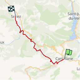
Tour Pferd von 18,3 km verfügbar auf Provence-Alpes-Côte d'Azur, Alpes-de-Haute-Provence, Castellane. Diese Tour wird von tracegps vorgeschlagen.
Beschreibung
Le 26 février 1815, Napoléon quitte l’île d’Elbe, débarque à Golfe Juan le 1er mars et gagne Paris, avec ses hommes, le 20 mars 1815. Il traverse Castellane et Digne-les-Bains les 3 et 4 mars 1815. Ce cheminement historique a donné lieu à la création d'un itinéraire de randonnée thématique unique en France : la Voie Impériale, reliant Castellane et Digne-les-Bains sur une distance de 52 km. La randonnée qui peut s’effectuer à pied ou à cheval (cavalier confirmé), permet de traverser des paysages encore vierges et authentiques de la Haute Provence et de découvrir un patrimoine remarquable au fil des étapes. Retrouvez la voie Impériale sur le site de la Communauté de Communes du Moyen Verdon
Ort
Kommentare
Touren in der Umgebung
![Tour Wandern Castellane - Sentier des Siréniens - Photo](https://media.geolcdn.com/t/375/260/ext.jpg?maxdim=2&url=https%3A%2F%2Fservices.sitytrail.com%2FGeolivesWS%2FDownloadMedia.ashx%3FTrailID%3D1056050%26Media%3Dfix__20181013150513.jpg)
![Wandern Wandern](https://static1.geolcdn.com/sitytour/trail-icons/101.png)
Wandern
![](/images/other/stat-length.png)
![](https://static1.geolcdn.com/siteimages/upload/files/16400158638029165_repeat_loop_refresh_sync_direction_icon.png)
![Tour Wandern Castellane - cadiere de brandis - Photo](https://media.geolcdn.com/t/375/260/ext.jpg?maxdim=2&url=https%3A%2F%2Fservices.sitytrail.com%2FGeolivesWS%2FDownloadMedia.ashx%3FTrailID%3D138609%26Media%3D20120712104941.jpeg)
![Wandern Wandern](https://static1.geolcdn.com/sitytour/trail-icons/101.png)
Wandern
![](/images/other/stat-length.png)
![](https://static1.geolcdn.com/siteimages/upload/files/16400158638029165_repeat_loop_refresh_sync_direction_icon.png)
![Mountainbike Mountainbike](https://static1.geolcdn.com/sitytour/trail-icons/202.png)
Mountainbike
![](/images/other/stat-length.png)
![](https://static1.geolcdn.com/siteimages/upload/files/16400158638029165_repeat_loop_refresh_sync_direction_icon.png)
![Tour Wandern Castellane - Cadières de Brandis version Light - Photo](https://media.geolcdn.com/t/375/260/605f0da0-c80c-45b5-84af-1edbec3be1ea.jpg&format=jpg&maxdim=2)
![Wandern Wandern](https://static1.geolcdn.com/sitytour/trail-icons/101.png)
Wandern
![](/images/other/stat-length.png)
![](https://static1.geolcdn.com/siteimages/upload/files/16400158638029165_repeat_loop_refresh_sync_direction_icon.png)
![Tour Wandern Castellane - Cadières de Brandis - Photo](https://media.geolcdn.com/t/375/260/ext.jpg?maxdim=2&url=https%3A%2F%2Fstatic1.geolcdn.com%2Fsiteimages%2Fupload%2Ffiles%2F1553511878bg_sport_marche.png)
![Wandern Wandern](https://static1.geolcdn.com/sitytour/trail-icons/101.png)
Wandern
![](/images/other/stat-length.png)
![](https://static1.geolcdn.com/siteimages/upload/files/16400158638029165_repeat_loop_refresh_sync_direction_icon.png)
![Tour Wandern Castellane - la colle cadieres de brandis 20kms 1086m - Photo](https://media.geolcdn.com/t/375/260/d2556f93-acba-4de2-87f5-52e88683f173.jpg&format=jpg&maxdim=2)
![Wandern Wandern](https://static1.geolcdn.com/sitytour/trail-icons/101.png)
Wandern
![](/images/other/stat-length.png)
![](https://static1.geolcdn.com/siteimages/upload/files/16400158638029165_repeat_loop_refresh_sync_direction_icon.png)
![Tour Wandern Castellane - castellane - Photo](https://media.geolcdn.com/t/375/260/ef06b05b-8807-4e7d-9459-ab4108fe9a75.jpg&format=jpg&maxdim=2)
![Wandern Wandern](https://static1.geolcdn.com/sitytour/trail-icons/101.png)
Wandern
![](/images/other/stat-length.png)
![](https://static1.geolcdn.com/siteimages/upload/files/16400158638029165_repeat_loop_refresh_sync_direction_icon.png)
![Tour Wandern Castellane - La Colle : Cadières de Brandis - Photo](https://media.geolcdn.com/t/375/260/c8417374-dd6d-4c42-aafc-c75ff17f0957.jpg&format=jpg&maxdim=2)
![Wandern Wandern](https://static1.geolcdn.com/sitytour/trail-icons/101.png)
Wandern
![](/images/other/stat-length.png)
![](https://static1.geolcdn.com/siteimages/upload/files/16400158638029165_repeat_loop_refresh_sync_direction_icon.png)
![Tour Wandern Demandolx - Demandolx cremon 1000m 16kms - Photo](https://media.geolcdn.com/t/375/260/b7cd96b9-33eb-4641-9b29-6e612e91eee7.jpg&format=jpg&maxdim=2)
![Wandern Wandern](https://static1.geolcdn.com/sitytour/trail-icons/101.png)
Wandern
![](/images/other/stat-length.png)
![](https://static1.geolcdn.com/siteimages/upload/files/16400158638029165_repeat_loop_refresh_sync_direction_icon.png)