![](/images/other/stat-length.png)
![Tour Andere Aktivitäten Waldenburg - Wasserfallen - Passwang - Photo](https://media.geolcdn.com/t/1900/400/ext.pjpeg?maxdim=2&url=https%3A%2F%2Fstatic1.geolcdn.com%2Fsiteimages%2Fupload%2Ffiles%2F1545311037marcheuse_200dpi.jpg)
Wasserfallen - Passwang
muelltho
Benutzer
![Länge](/images/other/stat-length.png)
Länge
6,3 km
![Maximale Höhe](https://static1.geolcdn.com/siteimages/upload/files/1508320355ic_sort_altitude_max_24dp.png)
Maximale Höhe
1194 m
![Positive Höhendifferenz](https://static1.geolcdn.com/siteimages/upload/files/1508320355ic_sort_den_pos_24dp.png)
Positive Höhendifferenz
311 m
![Km-Effort](/images/other/stat-length.png)
Km-Effort
10,5 km
![Min. Höhe](https://static1.geolcdn.com/siteimages/upload/files/1508320355ic_sort_altitude_min_24dp.png)
Min. Höhe
924 m
![Negative Höhendifferenz](https://static1.geolcdn.com/siteimages/upload/files/1508320355ic_sort_den_neg_24dp.png)
Negative Höhendifferenz
316 m
![Boucle](https://static1.geolcdn.com/siteimages/upload/files/16400158638029165_repeat_loop_refresh_sync_direction_icon.png)
Boucle
Ja
Erstellungsdatum :
2014-12-11 00:00:00.0
Letzte Änderung :
2014-12-11 00:00:00.0
![Andere Aktivitäten](https://static1.geolcdn.com/sitytour/trail-icons/900.png)
2h25
Schwierigkeit : Unbekannt
![Scannen Sie diesen QR-Code, um die Tour in der SityTrail-Anwendung zu öffnen](https://capi.geolives.com/qq0zvz2zws4bq2lad0pu/sitytour/trails/19043/qr.png?size=200)
Kostenlosegpshiking-Anwendung
Über SityTrail
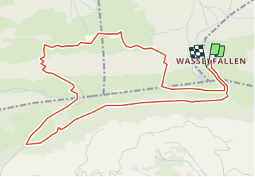
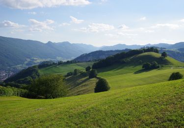
Tour Andere Aktivitäten von 6,3 km verfügbar auf Basel-Landschaft, Bezirk Waldenburg, Waldenburg. Diese Tour wird von muelltho vorgeschlagen.
Beschreibung
Bergstation (920 m) - Hintere Wasserfallen (955 m) - Passwang (1204 m) - Vogelberg (1107 m) - Bürten (992 m) - Huerewägeli - Hintere Wasserfallen - Bergstation (920 m)
Ort
Land:
Switzerland
Region :
Basel-Landschaft
Abteilung/Provinz :
Bezirk Waldenburg
Kommune :
Waldenburg
Standort:
Unknown
Gehen Sie:(Dec)
Gehen Sie:(UTM)
401872 ; 5247499 (32T) N.
Kommentare
Touren in der Umgebung
![Tour Zu Fuß - Gondelbahn - Wasserfallen - Photo](https://media.geolcdn.com/t/375/260/5b91cc13-ed8d-4eb3-9692-9dcec32168f3.jpeg&format=jpg&maxdim=2)
![Zu Fuß Zu Fuß](https://static1.geolcdn.com/sitytour/trail-icons/100.png)
Gondelbahn - Wasserfallen
Zu Fuß
Einfach
,
Basel-Landschaft,
Bezirk Waldenburg,
Switzerland
![](/images/other/stat-length.png)
4 km | 7,6 km-effort
1h 43min
![](https://static1.geolcdn.com/siteimages/upload/files/16400158638029165_repeat_loop_refresh_sync_direction_icon.png)
Nein
![Tour Zu Fuß Holderbank (SO) - Bereten Linde - Holderbank - Photo](https://media.geolcdn.com/t/375/260/6553f28c-7f26-4220-a5cc-4d625de86627.jpeg&format=jpg&maxdim=2)
![Zu Fuß Zu Fuß](https://static1.geolcdn.com/sitytour/trail-icons/100.png)
Bereten Linde - Holderbank
Zu Fuß
Einfach
Holderbank (SO),
Solothurn,
Bezirk Thal,
Switzerland
![](/images/other/stat-length.png)
4,5 km | 6 km-effort
1h 21min
![](https://static1.geolcdn.com/siteimages/upload/files/16400158638029165_repeat_loop_refresh_sync_direction_icon.png)
Nein
![Tour Zu Fuß Holderbank (SO) - Bereten Linde - fixme - Photo](https://media.geolcdn.com/t/375/260/c3094905-f8ed-4ba0-8039-2f99801712fe.jpeg&format=jpg&maxdim=2)
![Zu Fuß Zu Fuß](https://static1.geolcdn.com/sitytour/trail-icons/100.png)
Bereten Linde - fixme
Zu Fuß
Einfach
Holderbank (SO),
Solothurn,
Bezirk Thal,
Switzerland
![](/images/other/stat-length.png)
4 km | 5,5 km-effort
1h 14min
![](https://static1.geolcdn.com/siteimages/upload/files/16400158638029165_repeat_loop_refresh_sync_direction_icon.png)
Nein
![Tour Zu Fuß Mümliswil-Ramiswil - Wasserfallen Rochus Kapelle - Mümliswil - Photo](https://media.geolcdn.com/t/375/260/6f67bbaf-75f7-4a8b-9716-50801b2f8d89.jpeg&format=jpg&maxdim=2)
![Zu Fuß Zu Fuß](https://static1.geolcdn.com/sitytour/trail-icons/100.png)
Wasserfallen Rochus Kapelle - Mümliswil
Zu Fuß
Einfach
Mümliswil-Ramiswil,
Solothurn,
Bezirk Thal,
Switzerland
![](/images/other/stat-length.png)
4,2 km | 5,9 km-effort
1h 20min
![](https://static1.geolcdn.com/siteimages/upload/files/16400158638029165_repeat_loop_refresh_sync_direction_icon.png)
Nein
![Tour Zu Fuß Holderbank (SO) - Bereten Linde - Holderbank - Photo](https://media.geolcdn.com/t/375/260/222514eb-0149-4cb5-adfe-8bfb53339be1.jpeg&format=jpg&maxdim=2)
![Zu Fuß Zu Fuß](https://static1.geolcdn.com/sitytour/trail-icons/100.png)
Bereten Linde - Holderbank
Zu Fuß
Einfach
Holderbank (SO),
Solothurn,
Bezirk Thal,
Switzerland
![](/images/other/stat-length.png)
3,8 km | 4,6 km-effort
1h 2min
![](https://static1.geolcdn.com/siteimages/upload/files/16400158638029165_repeat_loop_refresh_sync_direction_icon.png)
Nein
![Tour Zu Fuß Oberdorf (BL) - Rebenweg - Photo](https://media.geolcdn.com/t/375/260/6332490e-decd-4e95-9c10-6d2db3e79c47.jpeg&format=jpg&maxdim=2)
![Zu Fuß Zu Fuß](https://static1.geolcdn.com/sitytour/trail-icons/100.png)
Rebenweg
Zu Fuß
Einfach
Oberdorf (BL),
Basel-Landschaft,
Bezirk Waldenburg,
Switzerland
![](/images/other/stat-length.png)
4,6 km | 7,3 km-effort
1h 40min
![](https://static1.geolcdn.com/siteimages/upload/files/16400158638029165_repeat_loop_refresh_sync_direction_icon.png)
Nein
![Tour Zu Fuß Holderbank (SO) - Bereten Linde - St. Wolfgang - Photo](https://media.geolcdn.com/t/375/260/222514eb-0149-4cb5-adfe-8bfb53339be1.jpeg&format=jpg&maxdim=2)
![Zu Fuß Zu Fuß](https://static1.geolcdn.com/sitytour/trail-icons/100.png)
Bereten Linde - St. Wolfgang
Zu Fuß
Einfach
Holderbank (SO),
Solothurn,
Bezirk Thal,
Switzerland
![](/images/other/stat-length.png)
3,9 km | 5,2 km-effort
1h 10min
![](https://static1.geolcdn.com/siteimages/upload/files/16400158638029165_repeat_loop_refresh_sync_direction_icon.png)
Nein
![Tour Zu Fuß Langenbruck - Helfenberg - Mümliswil - Photo](https://media.geolcdn.com/t/375/260/2730446c-37ba-4435-95a3-4c7a41237784.jpeg&format=jpg&maxdim=2)
![Zu Fuß Zu Fuß](https://static1.geolcdn.com/sitytour/trail-icons/100.png)
Helfenberg - Mümliswil
Zu Fuß
Einfach
Langenbruck,
Basel-Landschaft,
Bezirk Waldenburg,
Switzerland
![](/images/other/stat-length.png)
3,9 km | 5,3 km-effort
1h 11min
![](https://static1.geolcdn.com/siteimages/upload/files/16400158638029165_repeat_loop_refresh_sync_direction_icon.png)
Nein
![Tour Zu Fuß Mümliswil-Ramiswil - Breitenhöchi - Langenbruck - Photo](https://media.geolcdn.com/t/375/260/2730446c-37ba-4435-95a3-4c7a41237784.jpeg&format=jpg&maxdim=2)
![Zu Fuß Zu Fuß](https://static1.geolcdn.com/sitytour/trail-icons/100.png)
Breitenhöchi - Langenbruck
Zu Fuß
Einfach
Mümliswil-Ramiswil,
Solothurn,
Bezirk Thal,
Switzerland
![](/images/other/stat-length.png)
3,6 km | 6,1 km-effort
1h 22min
![](https://static1.geolcdn.com/siteimages/upload/files/16400158638029165_repeat_loop_refresh_sync_direction_icon.png)
Nein