![](/images/other/stat-length.png)
![Tour Wandern Dauendorf - Dauendorf - Photo](https://media.geolcdn.com/t/1900/400/ext.pjpeg?maxdim=2&url=https%3A%2F%2Fservices.sitytrail.com%2FGeolivesWS%2FDownloadMedia.ashx%3FTrailID%3D189256%26Media%3D20130505122436.jpeg)
Dauendorf
VacheKiri67
Benutzer
![Länge](/images/other/stat-length.png)
![Maximale Höhe](https://static1.geolcdn.com/siteimages/upload/files/1508320355ic_sort_altitude_max_24dp.png)
![Positive Höhendifferenz](https://static1.geolcdn.com/siteimages/upload/files/1508320355ic_sort_den_pos_24dp.png)
![Km-Effort](/images/other/stat-length.png)
![Min. Höhe](https://static1.geolcdn.com/siteimages/upload/files/1508320355ic_sort_altitude_min_24dp.png)
![Negative Höhendifferenz](https://static1.geolcdn.com/siteimages/upload/files/1508320355ic_sort_den_neg_24dp.png)
![Boucle](https://static1.geolcdn.com/siteimages/upload/files/16400158638029165_repeat_loop_refresh_sync_direction_icon.png)
![Wandern](https://static1.geolcdn.com/sitytour/trail-icons/101.png)
5h09
Schwierigkeit : Medium
![Scannen Sie diesen QR-Code, um die Tour in der SityTrail-Anwendung zu öffnen](https://capi.geolives.com/qq0zvz2zws4bq2lad0pu/sitytour/trails/189256/qr.png?size=200)
Kostenlosegpshiking-Anwendung
Über SityTrail
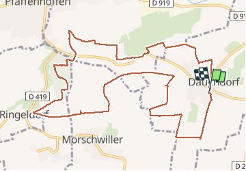
Tour Wandern von 14,3 km verfügbar auf Großer Osten, Unterelsass, Dauendorf. Diese Tour wird von VacheKiri67 vorgeschlagen.
Beschreibung
Distance 14,3km - Dénivelée 300m. Balisage : partiellement anneau jaune - anneau rouge - anneau jaune. Faite le 04/05/2013 en 5h10 (dont 0h55 de pause) avec notre fils de 8 ans. D'après : Randonnées et histoires N°10 page 77 : Sur les collines du Val de Moder.
Attention le balisage est parfois incomplet et les chemins sont boueux par temps de pluie.
Ort
Kommentare
Touren in der Umgebung
![Tour Zu Fuß Hagenau - Grand Circuit Du Stocklach - Photo](https://media.geolcdn.com/t/375/260/0f882276-9c73-4c14-9648-941cb4e0f9c1.jpeg&format=jpg&maxdim=2)
![Zu Fuß Zu Fuß](https://static1.geolcdn.com/sitytour/trail-icons/100.png)
Zu Fuß
![](/images/other/stat-length.png)
![](https://static1.geolcdn.com/siteimages/upload/files/16400158638029165_repeat_loop_refresh_sync_direction_icon.png)
![Tour Reiten Morschweiler - Circuit VDN Morschwiller ErnolsheimLesSaverne - Photo](https://media.geolcdn.com/t/375/260/f19dc88e-d969-4b7f-9c42-c921c33dfcff.jpg&format=jpg&maxdim=2)
![Reiten Reiten](https://static1.geolcdn.com/sitytour/trail-icons/301.png)
Reiten
![](/images/other/stat-length.png)
![](https://static1.geolcdn.com/siteimages/upload/files/16400158638029165_repeat_loop_refresh_sync_direction_icon.png)
![Tour Reiten Morschweiler - Circuit VDN Morschwiller Boucle par Ettendorf Dauendorf - Photo](https://media.geolcdn.com/t/375/260/6ab50801-489b-4eb1-b8a2-a912ce74877e.jpg&format=jpg&maxdim=2)
![Reiten Reiten](https://static1.geolcdn.com/sitytour/trail-icons/301.png)
Reiten
![](/images/other/stat-length.png)
![](https://static1.geolcdn.com/siteimages/upload/files/16400158638029165_repeat_loop_refresh_sync_direction_icon.png)
![Tour Reiten Morschweiler - Circuit VDN Morschwiller Boucle par Kirrwiller - Photo](https://media.geolcdn.com/t/375/260/8357f55f-b88f-48c9-b7a5-a3eb986ccfce.jpg&format=jpg&maxdim=2)
![Reiten Reiten](https://static1.geolcdn.com/sitytour/trail-icons/301.png)
Reiten
![](/images/other/stat-length.png)
![](https://static1.geolcdn.com/siteimages/upload/files/16400158638029165_repeat_loop_refresh_sync_direction_icon.png)
![Tour Reiten Morschweiler - Circuit VDN Morschwiller MerkwillerPechelbronn - Photo](https://media.geolcdn.com/t/375/260/acf1d5e4-bbd9-4b88-8920-d53af5ae0693.jpg&format=jpg&maxdim=2)
![Reiten Reiten](https://static1.geolcdn.com/sitytour/trail-icons/301.png)
Reiten
![](/images/other/stat-length.png)
![](https://static1.geolcdn.com/siteimages/upload/files/16400158638029165_repeat_loop_refresh_sync_direction_icon.png)
![Tour Reiten Morschweiler - Circuit VDN Morschwiller Wintzenheim - Photo](https://media.geolcdn.com/t/375/260/4935cda1-a751-4202-8a2a-00cca21fdfe6.jpg&format=jpg&maxdim=2)
![Reiten Reiten](https://static1.geolcdn.com/sitytour/trail-icons/301.png)
Reiten
![](/images/other/stat-length.png)
![](https://static1.geolcdn.com/siteimages/upload/files/16400158638029165_repeat_loop_refresh_sync_direction_icon.png)
![Tour Reiten Morschweiler - Circuit VDN Morschwiller Rothbach - Photo](https://media.geolcdn.com/t/375/260/5e8f61f5-2e57-4a9e-a488-46e4cfbdf97e.jpg&format=jpg&maxdim=2)
![Reiten Reiten](https://static1.geolcdn.com/sitytour/trail-icons/301.png)
Reiten
![](/images/other/stat-length.png)
![](https://static1.geolcdn.com/siteimages/upload/files/16400158638029165_repeat_loop_refresh_sync_direction_icon.png)
![Tour Pferd Merzweiler - 2012-08-19 Chevauchée EquiLanta Mertzwiller - Photo](https://media.geolcdn.com/t/375/260/ext.jpg?maxdim=2&url=https%3A%2F%2Fstatic1.geolcdn.com%2Fsiteimages%2Fupload%2Ffiles%2F1524743154cheval.jpg)
![Pferd Pferd](https://static1.geolcdn.com/sitytour/trail-icons/300.png)
Pferd
![](/images/other/stat-length.png)
![](https://static1.geolcdn.com/siteimages/upload/files/16400158638029165_repeat_loop_refresh_sync_direction_icon.png)
![Tour Wandern Dauendorf - Neubourg - Photo](https://media.geolcdn.com/t/375/260/ext.jpg?maxdim=2&url=https%3A%2F%2Fstatic1.geolcdn.com%2Fsiteimages%2Fupload%2Ffiles%2F1553511878bg_sport_marche.png)
![Wandern Wandern](https://static1.geolcdn.com/sitytour/trail-icons/101.png)
Wandern
![](/images/other/stat-length.png)
![](https://static1.geolcdn.com/siteimages/upload/files/16400158638029165_repeat_loop_refresh_sync_direction_icon.png)
Uberach
Une magnifique randonnée champêtre ! A faire absolument au printemps par beau soleil lorsque les pissenlits, pâquerettes, colza et arbres fruitiers sont en fleurs. La variété est au rendez-vous : collines, panoramas, prairies, chapelles, forêt, aires de pique-nique... Par contre à éviter par temps de pluie car les sentiers sont vite très boueux.