![](/images/other/stat-length.png)
![Tour Mountainbike Dardilly - Mont verdun - Photo](https://media.geolcdn.com/t/1900/400/ext.pjpeg?maxdim=2&url=https%3A%2F%2Fservices.sitytrail.com%2FGeolivesWS%2FDownloadMedia.ashx%3FTrailID%3D187850%26Media%3D7902de5c-05b1-4d77-b18c-d957dc412eb7.jpg)
Mont verdun
simon.paume
Benutzer
![Länge](/images/other/stat-length.png)
Länge
19,6 km
![Maximale Höhe](https://static1.geolcdn.com/siteimages/upload/files/1508320355ic_sort_altitude_max_24dp.png)
Maximale Höhe
602 m
![Positive Höhendifferenz](https://static1.geolcdn.com/siteimages/upload/files/1508320355ic_sort_den_pos_24dp.png)
Positive Höhendifferenz
469 m
![Km-Effort](/images/other/stat-length.png)
Km-Effort
26 km
![Min. Höhe](https://static1.geolcdn.com/siteimages/upload/files/1508320355ic_sort_altitude_min_24dp.png)
Min. Höhe
285 m
![Negative Höhendifferenz](https://static1.geolcdn.com/siteimages/upload/files/1508320355ic_sort_den_neg_24dp.png)
Negative Höhendifferenz
470 m
![Boucle](https://static1.geolcdn.com/siteimages/upload/files/16400158638029165_repeat_loop_refresh_sync_direction_icon.png)
Boucle
Ja
Erstellungsdatum :
2014-12-10 00:00:00.0
Letzte Änderung :
2014-12-10 00:00:00.0
![Mountainbike](https://static1.geolcdn.com/sitytour/trail-icons/202.png)
1h45
Schwierigkeit : Einfach
![Scannen Sie diesen QR-Code, um die Tour in der SityTrail-Anwendung zu öffnen](https://capi.geolives.com/qq0zvz2zws4bq2lad0pu/sitytour/trails/187850/qr.png?size=200)
Kostenlosegpshiking-Anwendung
Über SityTrail
Tour Mountainbike von 19,6 km verfügbar auf Auvergne-Rhone-Alpen, Métropole de Lyon, Dardilly. Diese Tour wird von simon.paume vorgeschlagen.
Beschreibung
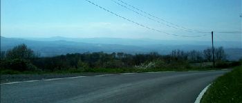
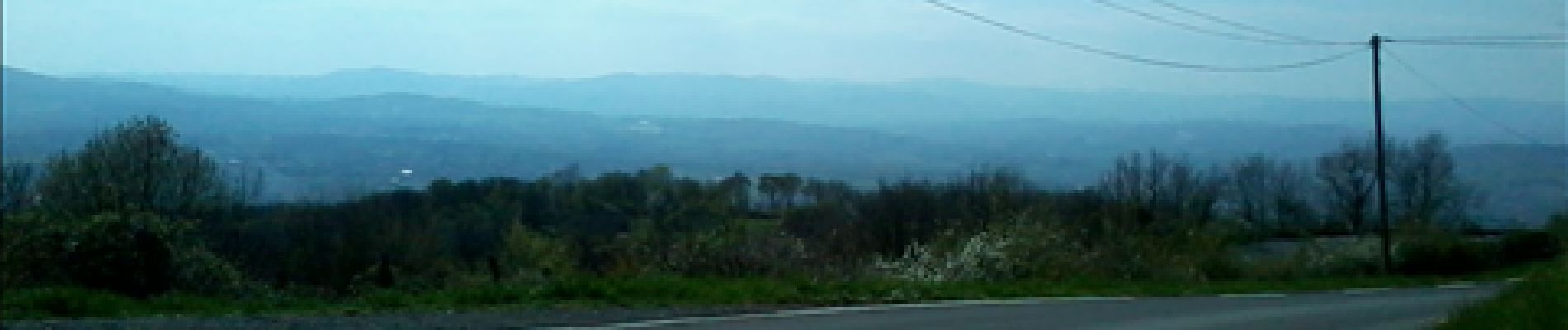
Randonnée facile mais montées très raide entre Le Puy d'Or et Limonest. Suivre le balisage jaune du dept. du Rhône puis balisage bleu des Monts d'Or
Ort
Land:
France
Region :
Auvergne-Rhone-Alpen
Abteilung/Provinz :
Métropole de Lyon
Kommune :
Dardilly
Standort:
Unknown
Gehen Sie:(Dec)
Gehen Sie:(UTM)
636215 ; 5073932 (31T) N.
Kommentare
Touren in der Umgebung
![Tour Laufen Limonest - Monts d'Or - Limonest - Photo](https://media.geolcdn.com/t/375/260/ext.jpg?maxdim=2&url=https%3A%2F%2Fservices.sitytrail.com%2FGeolivesWS%2FDownloadMedia.ashx%3FTrailID%3D118776%26Media%3D12977_1.jpg)
![Laufen Laufen](https://static1.geolcdn.com/sitytour/trail-icons/103.png)
Monts d'Or - Limonest
Laufen
Medium
(2)
Limonest,
Auvergne-Rhone-Alpen,
Métropole de Lyon,
France
![](/images/other/stat-length.png)
21 km | 32 km-effort
2h 0min
![](https://static1.geolcdn.com/siteimages/upload/files/16400158638029165_repeat_loop_refresh_sync_direction_icon.png)
Ja
![Tour Wandern Marcy-l'Étoile - 69 Marcy l'Etoile et les Monts du Lyonnais - Photo](https://media.geolcdn.com/t/375/260/ext.jpg?maxdim=2&url=https%3A%2F%2Fstatic1.geolcdn.com%2Fsiteimages%2Fupload%2Ffiles%2F1553511878bg_sport_marche.png)
![Wandern Wandern](https://static1.geolcdn.com/sitytour/trail-icons/101.png)
69 Marcy l'Etoile et les Monts du Lyonnais
Wandern
Medium
(1)
Marcy-l'Étoile,
Auvergne-Rhone-Alpen,
Métropole de Lyon,
France
![](/images/other/stat-length.png)
22 km | 30 km-effort
5h 0min
![](https://static1.geolcdn.com/siteimages/upload/files/16400158638029165_repeat_loop_refresh_sync_direction_icon.png)
Ja
![Tour Wandern Dommartin - A_DOMMARTIN 69380 Civrieux - Marand - Photo](https://media.geolcdn.com/t/375/260/ext.jpg?maxdim=2&url=https%3A%2F%2Fstatic1.geolcdn.com%2Fsiteimages%2Fupload%2Ffiles%2F1553511878bg_sport_marche.png)
![Wandern Wandern](https://static1.geolcdn.com/sitytour/trail-icons/101.png)
A_DOMMARTIN 69380 Civrieux - Marand
Wandern
Einfach
(1)
Dommartin,
Auvergne-Rhone-Alpen,
Rhône,
France
![](/images/other/stat-length.png)
10,1 km | 12,2 km-effort
3h 0min
![](https://static1.geolcdn.com/siteimages/upload/files/16400158638029165_repeat_loop_refresh_sync_direction_icon.png)
Ja
![Tour Mountainbike Lyon - Monts d'Or_02 - Photo](https://media.geolcdn.com/t/375/260/ext.jpg?maxdim=2&url=https%3A%2F%2Fstatic1.geolcdn.com%2Fsiteimages%2Fupload%2Ffiles%2F1524743154velo.jpg)
![Mountainbike Mountainbike](https://static1.geolcdn.com/sitytour/trail-icons/202.png)
Monts d'Or_02
Mountainbike
Medium
(2)
Lyon,
Auvergne-Rhone-Alpen,
Métropole de Lyon,
France
![](/images/other/stat-length.png)
32 km | 45 km-effort
2h 54min
![](https://static1.geolcdn.com/siteimages/upload/files/16400158638029165_repeat_loop_refresh_sync_direction_icon.png)
Ja
![Tour Mountainbike Dardilly - Mont Verdun 2 - Photo](https://media.geolcdn.com/t/375/260/ext.jpg?maxdim=2&url=https%3A%2F%2Fstatic1.geolcdn.com%2Fsiteimages%2Fupload%2Ffiles%2F1524743154velo.jpg)
![Mountainbike Mountainbike](https://static1.geolcdn.com/sitytour/trail-icons/202.png)
Mont Verdun 2
Mountainbike
Medium
(1)
Dardilly,
Auvergne-Rhone-Alpen,
Métropole de Lyon,
France
![](/images/other/stat-length.png)
17,9 km | 24 km-effort
1h 38min
![](https://static1.geolcdn.com/siteimages/upload/files/16400158638029165_repeat_loop_refresh_sync_direction_icon.png)
Ja
![Tour Mountainbike La Tour-de-Salvagny - La Tourelloise 2011 30km - Photo](https://media.geolcdn.com/t/375/260/ext.jpg?maxdim=2&url=https%3A%2F%2Fstatic1.geolcdn.com%2Fsiteimages%2Fupload%2Ffiles%2F1524743154velo.jpg)
![Mountainbike Mountainbike](https://static1.geolcdn.com/sitytour/trail-icons/202.png)
La Tourelloise 2011 30km
Mountainbike
Schwierig
(1)
La Tour-de-Salvagny,
Auvergne-Rhone-Alpen,
Métropole de Lyon,
France
![](/images/other/stat-length.png)
30 km | 42 km-effort
2h 30min
![](https://static1.geolcdn.com/siteimages/upload/files/16400158638029165_repeat_loop_refresh_sync_direction_icon.png)
Ja
![Tour Wandern Limonest - Tour de Limonest - Photo](https://media.geolcdn.com/t/375/260/ext.jpg?maxdim=2&url=https%3A%2F%2Fstatic1.geolcdn.com%2Fsiteimages%2Fupload%2Ffiles%2F1553511878bg_sport_marche.png)
![Wandern Wandern](https://static1.geolcdn.com/sitytour/trail-icons/101.png)
Tour de Limonest
Wandern
Medium
(2)
Limonest,
Auvergne-Rhone-Alpen,
Métropole de Lyon,
France
![](/images/other/stat-length.png)
9,1 km | 13,4 km-effort
2h 15min
![](https://static1.geolcdn.com/siteimages/upload/files/16400158638029165_repeat_loop_refresh_sync_direction_icon.png)
Nein
![Tour Wandern Écully - Le bois de Serres - Photo](https://media.geolcdn.com/t/375/260/d512f125-8af4-4c7f-a25d-89bf9b92124c.jpg&format=jpg&maxdim=2)
![Wandern Wandern](https://static1.geolcdn.com/sitytour/trail-icons/101.png)
Le bois de Serres
Wandern
Einfach
Écully,
Auvergne-Rhone-Alpen,
Métropole de Lyon,
France
![](/images/other/stat-length.png)
7 km | 9 km-effort
2h 9min
![](https://static1.geolcdn.com/siteimages/upload/files/16400158638029165_repeat_loop_refresh_sync_direction_icon.png)
Nein
![Tour Reiten Limonest - limonest2-hangar par azergues 17k - Photo](https://media.geolcdn.com/t/375/260/ext.jpg?maxdim=2&url=https%3A%2F%2Fstatic1.geolcdn.com%2Fsiteimages%2Fupload%2Ffiles%2F1524743154cheval.jpg)
![Reiten Reiten](https://static1.geolcdn.com/sitytour/trail-icons/301.png)
limonest2-hangar par azergues 17k
Reiten
Medium
(3)
Limonest,
Auvergne-Rhone-Alpen,
Métropole de Lyon,
France
![](/images/other/stat-length.png)
18,3 km | 21 km-effort
2h 41min
![](https://static1.geolcdn.com/siteimages/upload/files/16400158638029165_repeat_loop_refresh_sync_direction_icon.png)
Nein