![](/images/other/stat-length.png)
![Tour Wintersport Ballaigues - Lausanne-Yverdon (parcours inédit) - 3/4 - Photo](https://media.geolcdn.com/t/1900/400/ext.pjpeg?maxdim=2&url=https%3A%2F%2Fstatic1.geolcdn.com%2Fsiteimages%2Fupload%2Ffiles%2F1524743153ski.jpg)
Lausanne-Yverdon (parcours inédit) - 3/4
Romrando
Benutzer
![Länge](/images/other/stat-length.png)
![Maximale Höhe](https://static1.geolcdn.com/siteimages/upload/files/1508320355ic_sort_altitude_max_24dp.png)
![Positive Höhendifferenz](https://static1.geolcdn.com/siteimages/upload/files/1508320355ic_sort_den_pos_24dp.png)
![Km-Effort](/images/other/stat-length.png)
![Min. Höhe](https://static1.geolcdn.com/siteimages/upload/files/1508320355ic_sort_altitude_min_24dp.png)
![Negative Höhendifferenz](https://static1.geolcdn.com/siteimages/upload/files/1508320355ic_sort_den_neg_24dp.png)
![Boucle](https://static1.geolcdn.com/siteimages/upload/files/16400158638029165_repeat_loop_refresh_sync_direction_icon.png)
![Wintersport](https://static1.geolcdn.com/sitytour/trail-icons/500.png)
--
Schwierigkeit : Unbekannt
![Scannen Sie diesen QR-Code, um die Tour in der SityTrail-Anwendung zu öffnen](https://capi.geolives.com/qq0zvz2zws4bq2lad0pu/sitytour/trails/18546/qr.png?size=200)
Kostenlosegpshiking-Anwendung
Über SityTrail
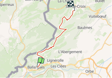
Tour Wintersport von 18,3 km verfügbar auf Waadt, District du Jura-Nord vaudois, Ballaigues. Diese Tour wird von Romrando vorgeschlagen.
Beschreibung
Source:geocities.com/romrando
Lausanne - Yverdon - 3/4
Partie 3 : Ballaigues - Ste-Croix
De Ballaigues remonter une petite route pour gagner "La Bessone" (>>>). Au carrefour prendre à gauche sur 400m puis à droite on rejoint l''alpage de "La Tiole". (Restauration, cadre sympa, réservation recommandée).
Rejoindre la route et continuer d''abord vers le NW par une route carrossable puis vers le NE (>>) pour monter sur le le Bel Coster (coup d''oeils magnifiques). On descend ensuite sur "La Poyette". Par le nord on contourne tout le Suchet par une succession de chemins plus ou moins bons. On atteint l''alpage de "Grange Neuve" (restauration, très fréquenté).
Descendre la route juqu''à la croisée puis prendre à gauche et franchir le col de l''Aiguillon. Redescendre vers le NE et 500 m après "La Gite Dessus" prendre à droite un chemin qui descend "La Sagne".
Ort
Kommentare
Touren in der Umgebung
![Tour Mountainbike Vallorbe - Le Suchet - Photo](https://media.geolcdn.com/t/375/260/ext.jpg?maxdim=2&url=https%3A%2F%2Fstatic1.geolcdn.com%2Fsiteimages%2Fupload%2Ffiles%2F1524743154velo.jpg)
![Mountainbike Mountainbike](https://static1.geolcdn.com/sitytour/trail-icons/202.png)
Mountainbike
![](/images/other/stat-length.png)
![](https://static1.geolcdn.com/siteimages/upload/files/16400158638029165_repeat_loop_refresh_sync_direction_icon.png)
![Tour Zu Fuß Les Clées - fixme - fixme - Photo](https://media.geolcdn.com/t/375/260/69516fc4-f099-4dd3-b5b2-2f14f3d78d3c.jpeg&format=jpg&maxdim=2)
![Zu Fuß Zu Fuß](https://static1.geolcdn.com/sitytour/trail-icons/100.png)
Zu Fuß
![](/images/other/stat-length.png)
![](https://static1.geolcdn.com/siteimages/upload/files/16400158638029165_repeat_loop_refresh_sync_direction_icon.png)
![Tour Zu Fuß Les Clées - Tourisme pédestre - Photo](https://media.geolcdn.com/t/375/260/69516fc4-f099-4dd3-b5b2-2f14f3d78d3c.jpeg&format=jpg&maxdim=2)
![Zu Fuß Zu Fuß](https://static1.geolcdn.com/sitytour/trail-icons/100.png)
Zu Fuß
![](/images/other/stat-length.png)
![](https://static1.geolcdn.com/siteimages/upload/files/16400158638029165_repeat_loop_refresh_sync_direction_icon.png)
![Tour Zu Fuß Ballaigues - Ballaigues-Vallorbe - Photo](https://media.geolcdn.com/t/375/260/94e39ae2-cd96-4289-ab6b-b58b7f70c35d.jpeg&format=jpg&maxdim=2)
![Zu Fuß Zu Fuß](https://static1.geolcdn.com/sitytour/trail-icons/100.png)
Zu Fuß
![](/images/other/stat-length.png)
![](https://static1.geolcdn.com/siteimages/upload/files/16400158638029165_repeat_loop_refresh_sync_direction_icon.png)
![Tour Zu Fuß Juriens - TP Mollendruz - Romainmôtie - Photo](https://media.geolcdn.com/t/375/260/dev_7316eb13-f07d-4453-9d47-20985e85773c.jpeg&format=jpg&maxdim=2)
![Zu Fuß Zu Fuß](https://static1.geolcdn.com/sitytour/trail-icons/100.png)
Zu Fuß
![](/images/other/stat-length.png)
![](https://static1.geolcdn.com/siteimages/upload/files/16400158638029165_repeat_loop_refresh_sync_direction_icon.png)
![Tour Wandern Métabief - GTJ Metabief - Pontarlier - Photo](https://media.geolcdn.com/t/375/260/ext.jpg?maxdim=2&url=https%3A%2F%2Fstatic1.geolcdn.com%2Fsiteimages%2Fupload%2Ffiles%2F1553511878bg_sport_marche.png)
![Wandern Wandern](https://static1.geolcdn.com/sitytour/trail-icons/101.png)
Wandern
![](/images/other/stat-length.png)
![](https://static1.geolcdn.com/siteimages/upload/files/16400158638029165_repeat_loop_refresh_sync_direction_icon.png)
![Tour Wandern Métabief - Le mont d 0r - Photo](https://media.geolcdn.com/t/375/260/dfbdcbfb-f5e1-43ae-8768-86e7f8471cb6.jpg&format=jpg&maxdim=2)
![Wandern Wandern](https://static1.geolcdn.com/sitytour/trail-icons/101.png)
Wandern
![](/images/other/stat-length.png)
![](https://static1.geolcdn.com/siteimages/upload/files/16400158638029165_repeat_loop_refresh_sync_direction_icon.png)
![Tour Wandern Jougne - La Jougnena - Photo](https://media.geolcdn.com/t/375/260/ext.jpg?maxdim=2&url=https%3A%2F%2Fstatic1.geolcdn.com%2Fsiteimages%2Fupload%2Ffiles%2F1553511878bg_sport_marche.png)
![Wandern Wandern](https://static1.geolcdn.com/sitytour/trail-icons/101.png)
Wandern
![](/images/other/stat-length.png)
![](https://static1.geolcdn.com/siteimages/upload/files/16400158638029165_repeat_loop_refresh_sync_direction_icon.png)
![Tour Wandern Jougne - La poyette - Photo](https://media.geolcdn.com/t/375/260/7455827d-3f9e-4079-9524-3e53ae00a5a5.jpg&format=jpg&maxdim=2)
![Wandern Wandern](https://static1.geolcdn.com/sitytour/trail-icons/101.png)
Wandern
![](/images/other/stat-length.png)
![](https://static1.geolcdn.com/siteimages/upload/files/16400158638029165_repeat_loop_refresh_sync_direction_icon.png)