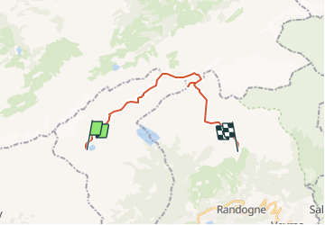
![](/images/other/stat-length.png)
![Tour Andere Aktivitäten Ayent - Le Valais par l''Adret - Etape 5/6 - Photo](https://media.geolcdn.com/t/1900/400/ext.pjpeg?maxdim=2&url=https%3A%2F%2Fstatic1.geolcdn.com%2Fsiteimages%2Fupload%2Ffiles%2F1545311037marcheuse_200dpi.jpg)
Le Valais par l''Adret - Etape 5/6
Romrando
Benutzer
![Länge](/images/other/stat-length.png)
![Maximale Höhe](https://static1.geolcdn.com/siteimages/upload/files/1508320355ic_sort_altitude_max_24dp.png)
![Positive Höhendifferenz](https://static1.geolcdn.com/siteimages/upload/files/1508320355ic_sort_den_pos_24dp.png)
![Km-Effort](/images/other/stat-length.png)
![Min. Höhe](https://static1.geolcdn.com/siteimages/upload/files/1508320355ic_sort_altitude_min_24dp.png)
![Negative Höhendifferenz](https://static1.geolcdn.com/siteimages/upload/files/1508320355ic_sort_den_neg_24dp.png)
![Boucle](https://static1.geolcdn.com/siteimages/upload/files/16400158638029165_repeat_loop_refresh_sync_direction_icon.png)
![Andere Aktivitäten](https://static1.geolcdn.com/sitytour/trail-icons/900.png)
--
Schwierigkeit : Unbekannt
![Scannen Sie diesen QR-Code, um die Tour in der SityTrail-Anwendung zu öffnen](https://capi.geolives.com/qq0zvz2zws4bq2lad0pu/sitytour/trails/18534/qr.png?size=200)
Kostenlosegpshiking-Anwendung
Über SityTrail
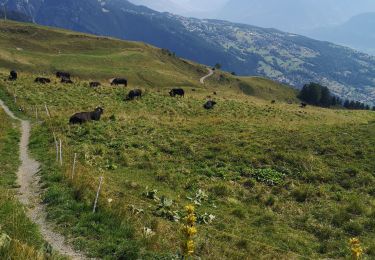
Tour Andere Aktivitäten von 16,9 km verfügbar auf Wallis, Ering, Ayent. Diese Tour wird von Romrando vorgeschlagen.
Beschreibung
Source:geocities.com/romrando
Etape 5
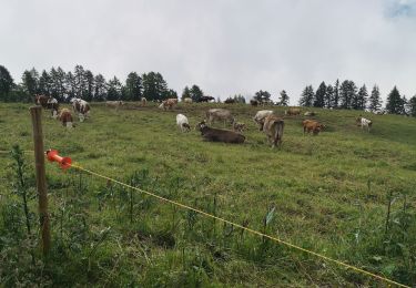
Cabane des Audannes - Cabane des Violettes (2''209 m) (Montana)
Descendre sous la cabane directement à l''W du lac en direction du col des Eaux froides. On atteint ce dernier par une courte montée.
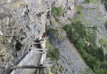
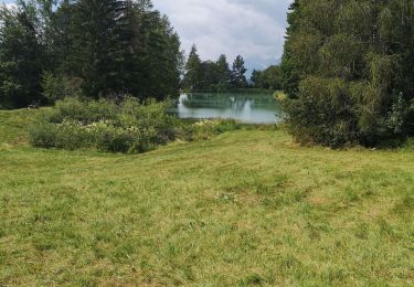
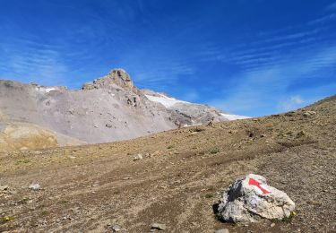
On s''engage alors dans le vallon qui lui fait suite jusqu''à la cote 2''457 m environ. Commence alors une longue traversée ascendante vers le N à travers une immense zone de lapiaz la plupart du temps très tranchants (Prudence !). La progression est lente et pénible. On suit marques et balises pour atteindre bientôt un poteau indicateur. Poursuivre dans la même direction pour atteindre le lac Ténéhet (nouveau poteau indicateur).
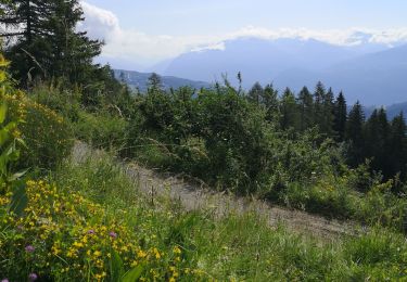
Continuer vers l''E, direction le lac du Plan des Roses où le chemin devient enfin plus facile.
La suite est confortable jusqu''au col du Rawil. On entame alors une nouvelle et raide montée jusqu''à la cabane Wildstrubel (petite restauration bienvenue !). Poursuivre vers le petit collet qui la domine et donnant l''accès à la Plaine Morte. Prendre alors a droite (SW) le chemin qui indique la direction du col du Pochet. On atteint bientôt une brèche (cordes fixes) qui donne l''accès à la combe au sud.
Ne pas manquer, avant de s''engager dans la descente, de se rendre vers le tout proche sommet voisin du Rohrbachstein (2''950 m) que l''on atteint facilement par son versant W (balisé). Le panorama y est total !
Par les cordes fixes on atteint le haut d''une grande combe que l''on on descend vers le lac Luton. De là une raide descente puis un chemin à flanc de coteau nous mène à un petit collet. On se dirige alors plein E en traversant horizontalement de fortes pentes pour rejoindre une combe au pied du col du Pochet.
Par une courte montée on atteint ce dernier. En 30 minutes on atteint alors la cabane des Violettes.
Ort
Kommentare
Touren in der Umgebung
![Tour Nordic Walking Arbaz - 19.08.20 cabane Audanne - Photo](https://media.geolcdn.com/t/375/260/4a273f5d-e24a-41dd-b2da-161f3b803f5a.jpg&format=jpg&maxdim=2)
![Nordic Walking Nordic Walking](https://static1.geolcdn.com/sitytour/trail-icons/102.png)
Nordic Walking
![](/images/other/stat-length.png)
![](https://static1.geolcdn.com/siteimages/upload/files/16400158638029165_repeat_loop_refresh_sync_direction_icon.png)
![Tour Wandern Icogne - Bisse du Ro - Photo](https://media.geolcdn.com/t/375/260/ext.jpg?maxdim=2&url=https%3A%2F%2Fservices.sitytrail.com%2FGeolivesWS%2FDownloadMedia.ashx%3FTrailID%3D451198%26Media%3D20150728135525.jpg)
![Wandern Wandern](https://static1.geolcdn.com/sitytour/trail-icons/101.png)
Wandern
![](/images/other/stat-length.png)
![](https://static1.geolcdn.com/siteimages/upload/files/16400158638029165_repeat_loop_refresh_sync_direction_icon.png)
![Tour Wandern Arbaz - pas de Maimbré - Photo](https://media.geolcdn.com/t/375/260/2f4ffc0a-5a0d-4039-bf72-c1b558daf964.jpg&format=jpg&maxdim=2)
![Wandern Wandern](https://static1.geolcdn.com/sitytour/trail-icons/101.png)
![Tour Wandern Ayent - le parzet - Photo](https://media.geolcdn.com/t/375/260/51f8b8c3-da82-46c6-b99e-15d6f0f21a72.jpg&format=jpg&maxdim=2)
![Wandern Wandern](https://static1.geolcdn.com/sitytour/trail-icons/101.png)
![Tour Wandern Ayent - étang long - Photo](https://media.geolcdn.com/t/375/260/d7eaae6d-95d3-4865-b79a-193a0271dc99.jpg&format=jpg&maxdim=2)
![Wandern Wandern](https://static1.geolcdn.com/sitytour/trail-icons/101.png)
![Tour Wandern Ayent - Samarin - Photo](https://media.geolcdn.com/t/375/260/45021b0f-9218-4f55-960a-d11ef9c49856.jpg&format=jpg&maxdim=2)
![Wandern Wandern](https://static1.geolcdn.com/sitytour/trail-icons/101.png)
![Tour Wandern Arbaz - rousses - Photo](https://media.geolcdn.com/t/375/260/02d2a0fd-38b4-479d-b4ea-66f5b7cb463e.jpg&format=jpg&maxdim=2)
![Wandern Wandern](https://static1.geolcdn.com/sitytour/trail-icons/101.png)
![Tour Wandern Arbaz - pas - Photo](https://media.geolcdn.com/t/375/260/7c798804-da96-421b-8be3-57252389b234.jpg&format=jpg&maxdim=2)
![Wandern Wandern](https://static1.geolcdn.com/sitytour/trail-icons/101.png)
![Tour Wandern Arbaz - les rousses - Photo](https://media.geolcdn.com/t/375/260/cbb2654d-8174-4cda-becf-2d9c37e569bb.jpg&format=jpg&maxdim=2)
![Wandern Wandern](https://static1.geolcdn.com/sitytour/trail-icons/101.png)