![](/images/other/stat-length.png)
![Tour Wandern Bully - A_BULLY 69210 Fours à Chaux - St Germain - Photo](https://media.geolcdn.com/t/1900/400/ext.pjpeg?maxdim=2&url=https%3A%2F%2Fstatic1.geolcdn.com%2Fsiteimages%2Fupload%2Ffiles%2F1553511878bg_sport_marche.png)
A_BULLY 69210 Fours à Chaux - St Germain
ANDREJAC
Benutzer
![Länge](/images/other/stat-length.png)
Länge
8,5 km
![Maximale Höhe](https://static1.geolcdn.com/siteimages/upload/files/1508320355ic_sort_altitude_max_24dp.png)
Maximale Höhe
348 m
![Positive Höhendifferenz](https://static1.geolcdn.com/siteimages/upload/files/1508320355ic_sort_den_pos_24dp.png)
Positive Höhendifferenz
172 m
![Km-Effort](/images/other/stat-length.png)
Km-Effort
10,7 km
![Min. Höhe](https://static1.geolcdn.com/siteimages/upload/files/1508320355ic_sort_altitude_min_24dp.png)
Min. Höhe
246 m
![Negative Höhendifferenz](https://static1.geolcdn.com/siteimages/upload/files/1508320355ic_sort_den_neg_24dp.png)
Negative Höhendifferenz
170 m
![Boucle](https://static1.geolcdn.com/siteimages/upload/files/16400158638029165_repeat_loop_refresh_sync_direction_icon.png)
Boucle
Ja
Erstellungsdatum :
2014-12-10 00:00:00.0
Letzte Änderung :
2014-12-10 00:00:00.0
![Wandern](https://static1.geolcdn.com/sitytour/trail-icons/101.png)
3h00
Schwierigkeit : Einfach
![Scannen Sie diesen QR-Code, um die Tour in der SityTrail-Anwendung zu öffnen](https://capi.geolives.com/qq0zvz2zws4bq2lad0pu/sitytour/trails/184176/qr.png?size=200)
Kostenlosegpshiking-Anwendung
Über SityTrail
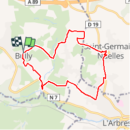
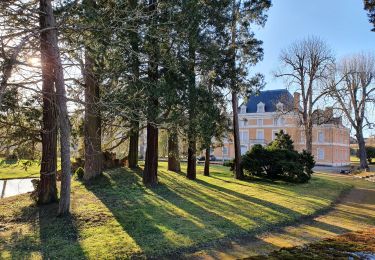
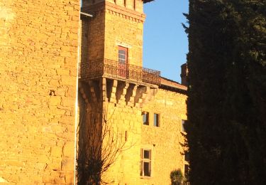
Tour Wandern von 8,5 km verfügbar auf Auvergne-Rhone-Alpen, Rhône, Bully. Diese Tour wird von ANDREJAC vorgeschlagen.
Beschreibung
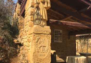
Départ de la Mairie; Sous Bully, Fours à Chaux, Les Molières, St Germain sur l''Arbresle, Les Places du lac, retour par Le Cruix.
Ort
Land:
France
Region :
Auvergne-Rhone-Alpen
Abteilung/Provinz :
Rhône
Kommune :
Bully
Standort:
Unknown
Gehen Sie:(Dec)
Gehen Sie:(UTM)
622958 ; 5078896 (31T) N.
Kommentare
Touren in der Umgebung
![Tour Wandern L'Arbresle - 2022-04-18_21h43m42_Fiche Verte n°9_L_Arbresle-1 - Photo](https://media.geolcdn.com/t/375/260/00218e51-a692-486e-8923-38995b6815db.jpg&format=jpg&maxdim=2)
![Wandern Wandern](https://static1.geolcdn.com/sitytour/trail-icons/101.png)
2022-04-18_21h43m42_Fiche Verte n°9_L_Arbresle-1
Wandern
Medium
(1)
L'Arbresle,
Auvergne-Rhone-Alpen,
Rhône,
France
![](/images/other/stat-length.png)
9,6 km | 11,8 km-effort
2h 40min
![](https://static1.geolcdn.com/siteimages/upload/files/16400158638029165_repeat_loop_refresh_sync_direction_icon.png)
Ja
![Tour Reiten Bully - BULLY nord 29k 38KF - Photo](https://media.geolcdn.com/t/375/260/ext.jpg?maxdim=2&url=https%3A%2F%2Fstatic1.geolcdn.com%2Fsiteimages%2Fupload%2Ffiles%2F1524743154cheval.jpg)
![Reiten Reiten](https://static1.geolcdn.com/sitytour/trail-icons/301.png)
BULLY nord 29k 38KF
Reiten
Schwierig
(1)
Bully,
Auvergne-Rhone-Alpen,
Rhône,
France
![](/images/other/stat-length.png)
30 km | 39 km-effort
5h 9min
![](https://static1.geolcdn.com/siteimages/upload/files/16400158638029165_repeat_loop_refresh_sync_direction_icon.png)
Ja
![Tour Wandern Chessy - Chessy 11 km - Photo](https://media.geolcdn.com/t/375/260/ext.jpg?maxdim=2&url=https%3A%2F%2Fstatic1.geolcdn.com%2Fsiteimages%2Fupload%2Ffiles%2F1553511878bg_sport_marche.png)
![Wandern Wandern](https://static1.geolcdn.com/sitytour/trail-icons/101.png)
Chessy 11 km
Wandern
Schwierig
(1)
Chessy,
Auvergne-Rhone-Alpen,
Rhône,
France
![](/images/other/stat-length.png)
11,5 km | 14,9 km-effort
3h 23min
![](https://static1.geolcdn.com/siteimages/upload/files/16400158638029165_repeat_loop_refresh_sync_direction_icon.png)
Ja
![Tour Wandern Chessy - Chessy à Bagnols - Photo](https://media.geolcdn.com/t/375/260/1a8d6b74-bd94-4883-b228-58b5e533ca39.jpg&format=jpg&maxdim=2)
![Wandern Wandern](https://static1.geolcdn.com/sitytour/trail-icons/101.png)
Chessy à Bagnols
Wandern
Schwierig
(1)
Chessy,
Auvergne-Rhone-Alpen,
Rhône,
France
![](/images/other/stat-length.png)
12,5 km | 15,8 km-effort
3h 35min
![](https://static1.geolcdn.com/siteimages/upload/files/16400158638029165_repeat_loop_refresh_sync_direction_icon.png)
Ja
![Tour Wandern Bully - bully - Photo](https://media.geolcdn.com/t/375/260/ext.jpg?maxdim=2&url=https%3A%2F%2Fstatic1.geolcdn.com%2Fsiteimages%2Fupload%2Ffiles%2F1553511878bg_sport_marche.png)
![Wandern Wandern](https://static1.geolcdn.com/sitytour/trail-icons/101.png)
bully
Wandern
Schwierig
(1)
Bully,
Auvergne-Rhone-Alpen,
Rhône,
France
![](/images/other/stat-length.png)
10,7 km | 13,6 km-effort
2h 57min
![](https://static1.geolcdn.com/siteimages/upload/files/16400158638029165_repeat_loop_refresh_sync_direction_icon.png)
Ja
![Tour Wandern Chessy - Chessy - Carrières de Gray - Photo](https://media.geolcdn.com/t/375/260/8d7c8e26-fc30-4464-a10b-7b34cdc4f32c.jpg&format=jpg&maxdim=2)
![Wandern Wandern](https://static1.geolcdn.com/sitytour/trail-icons/101.png)
Chessy - Carrières de Gray
Wandern
Sehr leicht
Chessy,
Auvergne-Rhone-Alpen,
Rhône,
France
![](/images/other/stat-length.png)
9,7 km | 13 km-effort
2h 33min
![](https://static1.geolcdn.com/siteimages/upload/files/16400158638029165_repeat_loop_refresh_sync_direction_icon.png)
Ja
![Tour Wandern Chessy - Chessy-Les-Mines - Rhône (15 km - D. 360 m) CV - Photo](https://media.geolcdn.com/t/375/260/ce9fa723-d3c4-4e6c-95ee-39645dc16ebd.jpg&format=jpg&maxdim=2)
![Wandern Wandern](https://static1.geolcdn.com/sitytour/trail-icons/101.png)
Chessy-Les-Mines - Rhône (15 km - D. 360 m) CV
Wandern
Medium
(1)
Chessy,
Auvergne-Rhone-Alpen,
Rhône,
France
![](/images/other/stat-length.png)
14,7 km | 19,5 km-effort
4h 9min
![](https://static1.geolcdn.com/siteimages/upload/files/16400158638029165_repeat_loop_refresh_sync_direction_icon.png)
Ja
![Tour Wandern Châtillon - Châtillon - La vallée de l'Azergues - Photo](https://media.geolcdn.com/t/375/260/4cdce229-584e-4928-b1f1-7fe54f3e81d4.jpg&format=jpg&maxdim=2)
![Wandern Wandern](https://static1.geolcdn.com/sitytour/trail-icons/101.png)
Châtillon - La vallée de l'Azergues
Wandern
Einfach
Châtillon,
Auvergne-Rhone-Alpen,
Rhône,
France
![](/images/other/stat-length.png)
4,2 km | 5,5 km-effort
1h 33min
![](https://static1.geolcdn.com/siteimages/upload/files/16400158638029165_repeat_loop_refresh_sync_direction_icon.png)
Ja
![Tour Wandern Chessy - Chessy-les-Mines (version 2) - 18 km - D. 326 m - Photo](https://media.geolcdn.com/t/375/260/34532d0c-e11f-43aa-b5d6-a2cbd4caceb3.jpeg&format=jpg&maxdim=2)
![Wandern Wandern](https://static1.geolcdn.com/sitytour/trail-icons/101.png)
Chessy-les-Mines (version 2) - 18 km - D. 326 m
Wandern
Medium
Chessy,
Auvergne-Rhone-Alpen,
Rhône,
France
![](/images/other/stat-length.png)
17,6 km | 22 km-effort
5h 42min
![](https://static1.geolcdn.com/siteimages/upload/files/16400158638029165_repeat_loop_refresh_sync_direction_icon.png)
Ja