![](/images/other/stat-length.png)
![Tour Wandern Clef-Vallée-d'Eure - LaCroixStLeufroy-Cailly_15.6Km - Photo](https://media.geolcdn.com/t/1900/400/ext.pjpeg?maxdim=2&url=https%3A%2F%2Fstatic1.geolcdn.com%2Fsiteimages%2Fupload%2Ffiles%2F1553511878bg_sport_marche.png)
LaCroixStLeufroy-Cailly_15.6Km
douneto
Benutzer
![Länge](/images/other/stat-length.png)
Länge
15,5 km
![Maximale Höhe](https://static1.geolcdn.com/siteimages/upload/files/1508320355ic_sort_altitude_max_24dp.png)
Maximale Höhe
159 m
![Positive Höhendifferenz](https://static1.geolcdn.com/siteimages/upload/files/1508320355ic_sort_den_pos_24dp.png)
Positive Höhendifferenz
277 m
![Km-Effort](/images/other/stat-length.png)
Km-Effort
19,2 km
![Min. Höhe](https://static1.geolcdn.com/siteimages/upload/files/1508320355ic_sort_altitude_min_24dp.png)
Min. Höhe
21 m
![Negative Höhendifferenz](https://static1.geolcdn.com/siteimages/upload/files/1508320355ic_sort_den_neg_24dp.png)
Negative Höhendifferenz
277 m
![Boucle](https://static1.geolcdn.com/siteimages/upload/files/16400158638029165_repeat_loop_refresh_sync_direction_icon.png)
Boucle
Ja
Erstellungsdatum :
2019-04-30 14:33:26.833
Letzte Änderung :
2019-04-30 14:33:26.869
![Wandern](https://static1.geolcdn.com/sitytour/trail-icons/101.png)
3h40
Schwierigkeit : Medium
![Scannen Sie diesen QR-Code, um die Tour in der SityTrail-Anwendung zu öffnen](https://capi.geolives.com/qq0zvz2zws4bq2lad0pu/sitytour/trails/182793/qr.png?size=200)
Kostenlosegpshiking-Anwendung
Über SityTrail
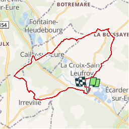
Tour Wandern von 15,5 km verfügbar auf Normandie, Eure, Clef-Vallée-d'Eure. Diese Tour wird von douneto vorgeschlagen.
Beschreibung
Pagnol en vallée d''Eure : (circuit de Eure MadrieSeine)
Rando Novembre 2016
Balisage Jaune principalement
Chemins de bonne qualité
Vues sur la vallée de l''Eure
GPS:49.099951, 1.243093
Ort
Land:
France
Region :
Normandie
Abteilung/Provinz :
Eure
Kommune :
Clef-Vallée-d'Eure
Standort:
Unknown
Gehen Sie:(Dec)
Gehen Sie:(UTM)
371758 ; 5440061 (31U) N.
Kommentare
Touren in der Umgebung
![Tour Wandern Clef-Vallée-d'Eure - Ecardenville sur Eure (122) - Photo](https://media.geolcdn.com/t/375/260/ext.jpg?maxdim=2&url=https%3A%2F%2Fstatic1.geolcdn.com%2Fsiteimages%2Fupload%2Ffiles%2F1553511878bg_sport_marche.png)
![Wandern Wandern](https://static1.geolcdn.com/sitytour/trail-icons/101.png)
Ecardenville sur Eure (122)
Wandern
Einfach
(1)
Clef-Vallée-d'Eure,
Normandie,
Eure,
France
![](/images/other/stat-length.png)
11,1 km | 13,2 km-effort
2h 54min
![](https://static1.geolcdn.com/siteimages/upload/files/16400158638029165_repeat_loop_refresh_sync_direction_icon.png)
Ja
![Wandern Wandern](https://static1.geolcdn.com/sitytour/trail-icons/101.png)
20240323-La Croix St Leuffroy
Wandern
Medium
Clef-Vallée-d'Eure,
Normandie,
Eure,
France
![](/images/other/stat-length.png)
11,1 km | 13,1 km-effort
3h 22min
![](https://static1.geolcdn.com/siteimages/upload/files/16400158638029165_repeat_loop_refresh_sync_direction_icon.png)
Ja
![Tour Wandern Autheuil-Authouillet - Ecardenville 6 novembre 2022 - Photo](https://media.geolcdn.com/t/375/260/ext.jpg?maxdim=2&url=https%3A%2F%2Fstatic1.geolcdn.com%2Fsiteimages%2Fupload%2Ffiles%2F1553511878bg_sport_marche.png)
![Wandern Wandern](https://static1.geolcdn.com/sitytour/trail-icons/101.png)
Ecardenville 6 novembre 2022
Wandern
Schwierig
(1)
Autheuil-Authouillet,
Normandie,
Eure,
France
![](/images/other/stat-length.png)
10,8 km | 13 km-effort
2h 54min
![](https://static1.geolcdn.com/siteimages/upload/files/16400158638029165_repeat_loop_refresh_sync_direction_icon.png)
Ja
![Wandern Wandern](https://static1.geolcdn.com/sitytour/trail-icons/101.png)
20220628-Heudreville le Jardin de René
Wandern
Medium
Heudreville-sur-Eure,
Normandie,
Eure,
France
![](/images/other/stat-length.png)
12 km | 14,1 km-effort
3h 37min
![](https://static1.geolcdn.com/siteimages/upload/files/16400158638029165_repeat_loop_refresh_sync_direction_icon.png)
Ja
![Tour Wandern Fontaine-sous-Jouy - Fontaine sous Jouy - Photo](https://media.geolcdn.com/t/375/260/ext.jpg?maxdim=2&url=https%3A%2F%2Fstatic1.geolcdn.com%2Fsiteimages%2Fupload%2Ffiles%2F1553511878bg_sport_marche.png)
![Wandern Wandern](https://static1.geolcdn.com/sitytour/trail-icons/101.png)
Fontaine sous Jouy
Wandern
Medium
(1)
Fontaine-sous-Jouy,
Normandie,
Eure,
France
![](/images/other/stat-length.png)
8 km | 8,7 km-effort
1h 54min
![](https://static1.geolcdn.com/siteimages/upload/files/16400158638029165_repeat_loop_refresh_sync_direction_icon.png)
Ja
![Tour Wandern Clef-Vallée-d'Eure - rando ot gaillon du 14 nov 2019 - Photo](https://media.geolcdn.com/t/375/260/9b1deed0-9e62-4748-93f4-622bd4dcf43e.jpg&format=jpg&maxdim=2)
![Wandern Wandern](https://static1.geolcdn.com/sitytour/trail-icons/101.png)
rando ot gaillon du 14 nov 2019
Wandern
Sehr leicht
Clef-Vallée-d'Eure,
Normandie,
Eure,
France
![](/images/other/stat-length.png)
7,3 km | 9,2 km-effort
2h 56min
![](https://static1.geolcdn.com/siteimages/upload/files/16400158638029165_repeat_loop_refresh_sync_direction_icon.png)
Ja
![Tour Wandern Fontaine-sous-Jouy - Fontaine sous jouy - Photo](https://media.geolcdn.com/t/375/260/ext.jpg?maxdim=2&url=https%3A%2F%2Fstatic1.geolcdn.com%2Fsiteimages%2Fupload%2Ffiles%2F1553511878bg_sport_marche.png)
![Wandern Wandern](https://static1.geolcdn.com/sitytour/trail-icons/101.png)
Fontaine sous jouy
Wandern
Einfach
(1)
Fontaine-sous-Jouy,
Normandie,
Eure,
France
![](/images/other/stat-length.png)
8,5 km | 9,2 km-effort
2h 19min
![](https://static1.geolcdn.com/siteimages/upload/files/16400158638029165_repeat_loop_refresh_sync_direction_icon.png)
Ja
![Tour Wandern Fontaine-sous-Jouy - Jouy sur eure - Photo](https://media.geolcdn.com/t/375/260/ext.jpg?maxdim=2&url=https%3A%2F%2Fservices.sitytrail.com%2FGeolivesWS%2FDownloadMedia.ashx%3FTrailID%3D483535%26Media%3Dfix__20151019163209.jpg)
![Wandern Wandern](https://static1.geolcdn.com/sitytour/trail-icons/101.png)
Jouy sur eure
Wandern
Medium
Fontaine-sous-Jouy,
Normandie,
Eure,
France
![](/images/other/stat-length.png)
13,4 km | 16,3 km-effort
3h 21min
![](https://static1.geolcdn.com/siteimages/upload/files/16400158638029165_repeat_loop_refresh_sync_direction_icon.png)
Ja
![Tour Wandern Jouy-sur-Eure - Rando Fontaine sous Jouy du 19 juin 2023 - Photo](https://media.geolcdn.com/t/375/260/e4d8d367-7ec3-488e-8244-21f33d7f80fd.jpg&format=jpg&maxdim=2)
![Wandern Wandern](https://static1.geolcdn.com/sitytour/trail-icons/101.png)
Rando Fontaine sous Jouy du 19 juin 2023
Wandern
Medium
Jouy-sur-Eure,
Normandie,
Eure,
France
![](/images/other/stat-length.png)
8,3 km | 9,1 km-effort
2h 34min
![](https://static1.geolcdn.com/siteimages/upload/files/16400158638029165_repeat_loop_refresh_sync_direction_icon.png)
Ja