![](/images/other/stat-length.png)
![Tour Wandern Carqueiranne - Fête de la Rando 2013 Circuit Bleu - Photo](https://media.geolcdn.com/t/1900/400/ext.pjpeg?maxdim=2&url=https%3A%2F%2Fstatic1.geolcdn.com%2Fsiteimages%2Fupload%2Ffiles%2F1553511878bg_sport_marche.png)
Fête de la Rando 2013 Circuit Bleu
jmheydorff
Benutzer
![Länge](/images/other/stat-length.png)
Länge
17,3 km
![Maximale Höhe](https://static1.geolcdn.com/siteimages/upload/files/1508320355ic_sort_altitude_max_24dp.png)
Maximale Höhe
297 m
![Positive Höhendifferenz](https://static1.geolcdn.com/siteimages/upload/files/1508320355ic_sort_den_pos_24dp.png)
Positive Höhendifferenz
631 m
![Km-Effort](/images/other/stat-length.png)
Km-Effort
26 km
![Min. Höhe](https://static1.geolcdn.com/siteimages/upload/files/1508320355ic_sort_altitude_min_24dp.png)
Min. Höhe
0 m
![Negative Höhendifferenz](https://static1.geolcdn.com/siteimages/upload/files/1508320355ic_sort_den_neg_24dp.png)
Negative Höhendifferenz
632 m
![Boucle](https://static1.geolcdn.com/siteimages/upload/files/16400158638029165_repeat_loop_refresh_sync_direction_icon.png)
Boucle
Ja
Erstellungsdatum :
2014-12-10 00:00:00.0
Letzte Änderung :
2014-12-10 00:00:00.0
![Wandern](https://static1.geolcdn.com/sitytour/trail-icons/101.png)
5h26
Schwierigkeit : Medium
![Scannen Sie diesen QR-Code, um die Tour in der SityTrail-Anwendung zu öffnen](https://capi.geolives.com/qq0zvz2zws4bq2lad0pu/sitytour/trails/182737/qr.png?size=200)
Kostenlosegpshiking-Anwendung
Über SityTrail
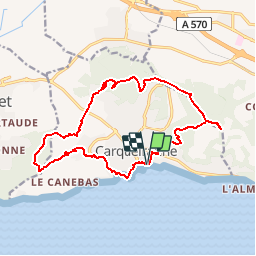
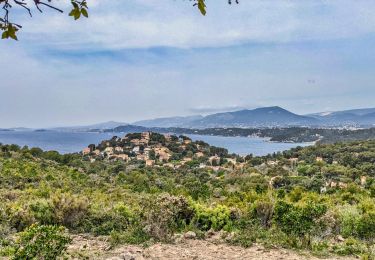
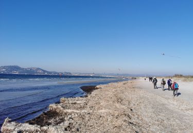
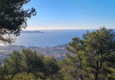
Tour Wandern von 17,3 km verfügbar auf Provence-Alpes-Côte d'Azur, Var, Carqueiranne. Diese Tour wird von jmheydorff vorgeschlagen.
Beschreibung
Paking RD 559 Est de Carqueiranne - Ne pas venir par le Nord de Carqueiranne (ch. du Col du Serre), très étroit , avec 2 virages très serrés.
Départ de la rando: Square des Pinchés, à côté du Port.
Ort
Land:
France
Region :
Provence-Alpes-Côte d'Azur
Abteilung/Provinz :
Var
Kommune :
Carqueiranne
Standort:
Unknown
Gehen Sie:(Dec)
Gehen Sie:(UTM)
262376 ; 4774683 (32T) N.
Kommentare
Touren in der Umgebung
![Tour Wandern La Crau - Le Paradis et le mont des oiseaux - Photo](https://media.geolcdn.com/t/375/260/3ea9709f-1bf2-4174-850e-73122825f7f5.jpg&format=jpg&maxdim=2)
![Wandern Wandern](https://static1.geolcdn.com/sitytour/trail-icons/101.png)
Le Paradis et le mont des oiseaux
Wandern
Medium
(1)
La Crau,
Provence-Alpes-Côte d'Azur,
Var,
France
![](/images/other/stat-length.png)
12,5 km | 19,9 km-effort
6h 30min
![](https://static1.geolcdn.com/siteimages/upload/files/16400158638029165_repeat_loop_refresh_sync_direction_icon.png)
Ja
![Tour Wandern Le Pradet - SityTrail - le Pradet les trois forts - Photo](https://media.geolcdn.com/t/375/260/f3d5c1c4-abd6-4c30-a189-71ee7c6f2626.jpg&format=jpg&maxdim=2)
![Wandern Wandern](https://static1.geolcdn.com/sitytour/trail-icons/101.png)
SityTrail - le Pradet les trois forts
Wandern
Sehr schwierig
(2)
Le Pradet,
Provence-Alpes-Côte d'Azur,
Var,
France
![](/images/other/stat-length.png)
13,3 km | 19,6 km-effort
4h 27min
![](https://static1.geolcdn.com/siteimages/upload/files/16400158638029165_repeat_loop_refresh_sync_direction_icon.png)
Ja
![Tour Zu Fuß Le Pradet - le pradet plage de la garonne la mine - Photo](https://media.geolcdn.com/t/375/260/ext.jpg?maxdim=2&url=https%3A%2F%2Fstatic1.geolcdn.com%2Fsiteimages%2Fupload%2Ffiles%2F1545311037marcheuse_200dpi.jpg)
![Zu Fuß Zu Fuß](https://static1.geolcdn.com/sitytour/trail-icons/100.png)
le pradet plage de la garonne la mine
Zu Fuß
Einfach
(1)
Le Pradet,
Provence-Alpes-Côte d'Azur,
Var,
France
![](/images/other/stat-length.png)
6,1 km | 8,2 km-effort
Unbekannt
![](https://static1.geolcdn.com/siteimages/upload/files/16400158638029165_repeat_loop_refresh_sync_direction_icon.png)
Ja
![Tour Wandern Le Pradet - les 3 forts depuis la plage de la Garonne - Photo](https://media.geolcdn.com/t/375/260/1cc1b5b0-8fc0-47a1-b418-a51de495ba7d.jpg&format=jpg&maxdim=2)
![Wandern Wandern](https://static1.geolcdn.com/sitytour/trail-icons/101.png)
les 3 forts depuis la plage de la Garonne
Wandern
Sehr schwierig
Le Pradet,
Provence-Alpes-Côte d'Azur,
Var,
France
![](/images/other/stat-length.png)
16,7 km | 24 km-effort
3h 59min
![](https://static1.geolcdn.com/siteimages/upload/files/16400158638029165_repeat_loop_refresh_sync_direction_icon.png)
Ja
![Tour Wandern Le Pradet - Mine de la Garonne 2-18-10-2024 - Photo](https://media.geolcdn.com/t/375/260/eb51cf3e-5952-413e-b535-93de1e3f672e.jpg&format=jpg&maxdim=2)
![Wandern Wandern](https://static1.geolcdn.com/sitytour/trail-icons/101.png)
Mine de la Garonne 2-18-10-2024
Wandern
Einfach
Le Pradet,
Provence-Alpes-Côte d'Azur,
Var,
France
![](/images/other/stat-length.png)
7,2 km | 9,6 km-effort
1h 55min
![](https://static1.geolcdn.com/siteimages/upload/files/16400158638029165_repeat_loop_refresh_sync_direction_icon.png)
Ja
![Tour Wandern Le Pradet - Les 3 forts-la Garonne-21-04-23 - Photo](https://media.geolcdn.com/t/375/260/cdf1f267-1743-49a7-b754-ec47dc9a915c.jpg&format=jpg&maxdim=2)
![Wandern Wandern](https://static1.geolcdn.com/sitytour/trail-icons/101.png)
Les 3 forts-la Garonne-21-04-23
Wandern
Medium
Le Pradet,
Provence-Alpes-Côte d'Azur,
Var,
France
![](/images/other/stat-length.png)
14,5 km | 21 km-effort
3h 56min
![](https://static1.geolcdn.com/siteimages/upload/files/16400158638029165_repeat_loop_refresh_sync_direction_icon.png)
Ja
![Tour Wandern Le Pradet - pointe du baou rouge - Photo](https://media.geolcdn.com/t/375/260/638f4642-859f-44ca-89f6-effdb663d305.jpg&format=jpg&maxdim=2)
![Wandern Wandern](https://static1.geolcdn.com/sitytour/trail-icons/101.png)
pointe du baou rouge
Wandern
Medium
Le Pradet,
Provence-Alpes-Côte d'Azur,
Var,
France
![](/images/other/stat-length.png)
6,8 km | 8,9 km-effort
2h 20min
![](https://static1.geolcdn.com/siteimages/upload/files/16400158638029165_repeat_loop_refresh_sync_direction_icon.png)
Ja
![Tour Wandern Hyères - Giens - Port Auguier - Chemin côtier - Photo](https://media.geolcdn.com/t/375/260/8600b71c-2160-4e50-bd7c-bba2a25051e4.jpg&format=jpg&maxdim=2)
![Wandern Wandern](https://static1.geolcdn.com/sitytour/trail-icons/101.png)
Giens - Port Auguier - Chemin côtier
Wandern
Einfach
Hyères,
Provence-Alpes-Côte d'Azur,
Var,
France
![](/images/other/stat-length.png)
8,6 km | 10,7 km-effort
6h 41min
![](https://static1.geolcdn.com/siteimages/upload/files/16400158638029165_repeat_loop_refresh_sync_direction_icon.png)
Ja
![Tour Wandern Carqueiranne - la grotte du paradis - Photo](https://media.geolcdn.com/t/375/260/9486f261-69b8-4de0-9e87-579eb1d901e8.jpg&format=jpg&maxdim=2)
![Wandern Wandern](https://static1.geolcdn.com/sitytour/trail-icons/101.png)
la grotte du paradis
Wandern
Einfach
(1)
Carqueiranne,
Provence-Alpes-Côte d'Azur,
Var,
France
![](/images/other/stat-length.png)
3,9 km | 6,6 km-effort
1h 35min
![](https://static1.geolcdn.com/siteimages/upload/files/16400158638029165_repeat_loop_refresh_sync_direction_icon.png)
Ja