![](/images/other/stat-length.png)
![Tour Wandern The Municipal District of Cahir — Cashel - Woodland Loop - Photo](https://media.geolcdn.com/t/1900/400/ext.pjpeg?maxdim=2&url=https%3A%2F%2Fstatic1.geolcdn.com%2Fsiteimages%2Fupload%2Ffiles%2F1553511878bg_sport_marche.png)
Woodland Loop
mlmoroneybb
Benutzer
![Länge](/images/other/stat-length.png)
Länge
1,2 km
![Maximale Höhe](https://static1.geolcdn.com/siteimages/upload/files/1508320355ic_sort_altitude_max_24dp.png)
Maximale Höhe
206 m
![Positive Höhendifferenz](https://static1.geolcdn.com/siteimages/upload/files/1508320355ic_sort_den_pos_24dp.png)
Positive Höhendifferenz
26 m
![Km-Effort](/images/other/stat-length.png)
Km-Effort
1,5 km
![Min. Höhe](https://static1.geolcdn.com/siteimages/upload/files/1508320355ic_sort_altitude_min_24dp.png)
Min. Höhe
170 m
![Negative Höhendifferenz](https://static1.geolcdn.com/siteimages/upload/files/1508320355ic_sort_den_neg_24dp.png)
Negative Höhendifferenz
25 m
![Boucle](https://static1.geolcdn.com/siteimages/upload/files/16400158638029165_repeat_loop_refresh_sync_direction_icon.png)
Boucle
Ja
Erstellungsdatum :
2014-12-10 00:00:00.0
Letzte Änderung :
2014-12-10 00:00:00.0
![Wandern](https://static1.geolcdn.com/sitytour/trail-icons/101.png)
21m
Schwierigkeit : Sehr leicht
![Scannen Sie diesen QR-Code, um die Tour in der SityTrail-Anwendung zu öffnen](https://capi.geolives.com/qq0zvz2zws4bq2lad0pu/sitytour/trails/182340/qr.png?size=200)
Kostenlosegpshiking-Anwendung
Über SityTrail
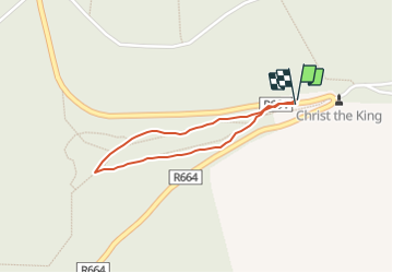
Tour Wandern von 1,2 km verfügbar auf Unbekannt, County Tipperary, The Municipal District of Cahir — Cashel. Diese Tour wird von mlmoroneybb vorgeschlagen.
Beschreibung
This loop is one of a series developed at two trailheads in the glen (Christ the King Statue and Lisvarrinane). Woodland Loop is the shortest of all the loops
Ort
Land:
Ireland
Region :
Unbekannt
Abteilung/Provinz :
County Tipperary
Kommune :
The Municipal District of Cahir — Cashel
Standort:
Clonbeg
Gehen Sie:(Dec)
Gehen Sie:(UTM)
556519 ; 5809173 (29U) N.
Kommentare
Touren in der Umgebung
![Tour Wandern The Municipal District of Cahir — Cashel - l diheen - Photo](https://media.geolcdn.com/t/375/260/ext.jpg?maxdim=2&url=https%3A%2F%2Fservices.sitytrail.com%2FGeolivesWS%2FDownloadMedia.ashx%3FTrailID%3D170808%26Media%3D20130120144216.jpg)
![Wandern Wandern](https://static1.geolcdn.com/sitytour/trail-icons/101.png)
l diheen
Wandern
Schwierig
The Municipal District of Cahir — Cashel,
Unbekannt,
County Tipperary,
Ireland
![](/images/other/stat-length.png)
16,3 km | 32 km-effort
5h 46min
![](https://static1.geolcdn.com/siteimages/upload/files/16400158638029165_repeat_loop_refresh_sync_direction_icon.png)
Ja
![Tour Wandern The Municipal District of Cahir — Cashel - Galtees - Lake Muskry Circuit - Photo](https://media.geolcdn.com/t/375/260/ext.jpg?maxdim=2&url=https%3A%2F%2Fservices.sitytrail.com%2FGeolivesWS%2FDownloadMedia.ashx%3FTrailID%3D45584%26Media%3Dimage6.jpg)
![Wandern Wandern](https://static1.geolcdn.com/sitytour/trail-icons/101.png)
Galtees - Lake Muskry Circuit
Wandern
Sehr leicht
The Municipal District of Cahir — Cashel,
Unbekannt,
County Tipperary,
Ireland
![](/images/other/stat-length.png)
10,1 km | 18,2 km-effort
3h 10min
![](https://static1.geolcdn.com/siteimages/upload/files/16400158638029165_repeat_loop_refresh_sync_direction_icon.png)
Nein
![Tour Laufen The Municipal District of Cahir — Cashel - Bianconi Loop - Photo](https://media.geolcdn.com/t/375/260/ext.jpg?maxdim=2&url=https%3A%2F%2Fstatic1.geolcdn.com%2Fsiteimages%2Fupload%2Ffiles%2F1524743154running.jpg)
![Laufen Laufen](https://static1.geolcdn.com/sitytour/trail-icons/103.png)
Bianconi Loop
Laufen
Einfach
The Municipal District of Cahir — Cashel,
Unbekannt,
County Tipperary,
Ireland
![](/images/other/stat-length.png)
3,8 km | 5,3 km-effort
2h 0min
![](https://static1.geolcdn.com/siteimages/upload/files/16400158638029165_repeat_loop_refresh_sync_direction_icon.png)
Ja
![Tour Laufen The Municipal District of Cahir — Cashel - Ballinacourty Loop - Photo](https://media.geolcdn.com/t/375/260/ext.jpg?maxdim=2&url=https%3A%2F%2Fstatic1.geolcdn.com%2Fsiteimages%2Fupload%2Ffiles%2F1524743154running.jpg)
![Laufen Laufen](https://static1.geolcdn.com/sitytour/trail-icons/103.png)
Ballinacourty Loop
Laufen
Medium
The Municipal District of Cahir — Cashel,
Unbekannt,
County Tipperary,
Ireland
![](/images/other/stat-length.png)
8,2 km | 10,9 km-effort
2h 0min
![](https://static1.geolcdn.com/siteimages/upload/files/16400158638029165_repeat_loop_refresh_sync_direction_icon.png)
Ja
![Tour Laufen The Municipal District of Cahir — Cashel - The Millenium Stone Loop - Photo](https://media.geolcdn.com/t/375/260/ext.jpg?maxdim=2&url=https%3A%2F%2Fstatic1.geolcdn.com%2Fsiteimages%2Fupload%2Ffiles%2F1524743154running.jpg)
![Laufen Laufen](https://static1.geolcdn.com/sitytour/trail-icons/103.png)
The Millenium Stone Loop
Laufen
Medium
The Municipal District of Cahir — Cashel,
Unbekannt,
County Tipperary,
Ireland
![](/images/other/stat-length.png)
9,4 km | 12,4 km-effort
2h 0min
![](https://static1.geolcdn.com/siteimages/upload/files/16400158638029165_repeat_loop_refresh_sync_direction_icon.png)
Ja
![Tour Wandern The Municipal District of Cahir — Cashel - Slievenamuck Walking Marathon Sunday March 24th 2013 - Photo](https://media.geolcdn.com/t/375/260/ext.jpg?maxdim=2&url=https%3A%2F%2Fstatic1.geolcdn.com%2Fsiteimages%2Fupload%2Ffiles%2F1553511878bg_sport_marche.png)
![Wandern Wandern](https://static1.geolcdn.com/sitytour/trail-icons/101.png)
Slievenamuck Walking Marathon Sunday March 24th 2013
Wandern
Schwierig
The Municipal District of Cahir — Cashel,
Unbekannt,
County Tipperary,
Ireland
![](/images/other/stat-length.png)
42 km | 56 km-effort
11h 36min
![](https://static1.geolcdn.com/siteimages/upload/files/16400158638029165_repeat_loop_refresh_sync_direction_icon.png)
Nein
![Tour Wandern The Municipal District of Cahir — Cashel - Galtee Walking Club Marathon - Photo](https://media.geolcdn.com/t/375/260/ext.jpg?maxdim=2&url=https%3A%2F%2Fstatic1.geolcdn.com%2Fsiteimages%2Fupload%2Ffiles%2F1553511878bg_sport_marche.png)
![Wandern Wandern](https://static1.geolcdn.com/sitytour/trail-icons/101.png)
Galtee Walking Club Marathon
Wandern
Schwierig
The Municipal District of Cahir — Cashel,
Unbekannt,
County Tipperary,
Ireland
![](/images/other/stat-length.png)
41 km | 54 km-effort
11h 22min
![](https://static1.geolcdn.com/siteimages/upload/files/16400158638029165_repeat_loop_refresh_sync_direction_icon.png)
Ja
![Tour Wandern The Municipal District of Cahir — Cashel - lisvarrinane new - Photo](https://media.geolcdn.com/t/375/260/ext.jpg?maxdim=2&url=https%3A%2F%2Fstatic1.geolcdn.com%2Fsiteimages%2Fupload%2Ffiles%2F1553511878bg_sport_marche.png)
![Wandern Wandern](https://static1.geolcdn.com/sitytour/trail-icons/101.png)
lisvarrinane new
Wandern
Einfach
The Municipal District of Cahir — Cashel,
Unbekannt,
County Tipperary,
Ireland
![](/images/other/stat-length.png)
4,6 km | 6 km-effort
1h 17min
![](https://static1.geolcdn.com/siteimages/upload/files/16400158638029165_repeat_loop_refresh_sync_direction_icon.png)
Ja
![Tour Wandern The Municipal District of Cahir — Cashel - Winter B 2012 - Photo](https://media.geolcdn.com/t/375/260/ext.jpg?maxdim=2&url=https%3A%2F%2Fstatic1.geolcdn.com%2Fsiteimages%2Fupload%2Ffiles%2F1553511878bg_sport_marche.png)
![Wandern Wandern](https://static1.geolcdn.com/sitytour/trail-icons/101.png)
Winter B 2012
Wandern
Medium
The Municipal District of Cahir — Cashel,
Unbekannt,
County Tipperary,
Ireland
![](/images/other/stat-length.png)
12,7 km | 17,3 km-effort
Unbekannt
![](https://static1.geolcdn.com/siteimages/upload/files/16400158638029165_repeat_loop_refresh_sync_direction_icon.png)
Ja