![](/images/other/stat-length.png)
![Tour Nordic Walking Rahon - Rahon - La Vouivre - L'étang - Photo](https://media.geolcdn.com/t/1900/400/ext.pjpeg?maxdim=2&url=https%3A%2F%2Fstatic1.geolcdn.com%2Fsiteimages%2Fupload%2Ffiles%2F1545311037marcheuse_200dpi.jpg)
Rahon - La Vouivre - L'étang
albert39
Benutzer
![Länge](/images/other/stat-length.png)
Länge
10,5 km
![Maximale Höhe](https://static1.geolcdn.com/siteimages/upload/files/1508320355ic_sort_altitude_max_24dp.png)
Maximale Höhe
251 m
![Positive Höhendifferenz](https://static1.geolcdn.com/siteimages/upload/files/1508320355ic_sort_den_pos_24dp.png)
Positive Höhendifferenz
99 m
![Km-Effort](/images/other/stat-length.png)
Km-Effort
11,8 km
![Min. Höhe](https://static1.geolcdn.com/siteimages/upload/files/1508320355ic_sort_altitude_min_24dp.png)
Min. Höhe
215 m
![Negative Höhendifferenz](https://static1.geolcdn.com/siteimages/upload/files/1508320355ic_sort_den_neg_24dp.png)
Negative Höhendifferenz
99 m
![Boucle](https://static1.geolcdn.com/siteimages/upload/files/16400158638029165_repeat_loop_refresh_sync_direction_icon.png)
Boucle
Ja
Erstellungsdatum :
2014-12-10 00:00:00.0
Letzte Änderung :
2014-12-10 00:00:00.0
![Nordic Walking](https://static1.geolcdn.com/sitytour/trail-icons/102.png)
2h19
Schwierigkeit : Medium
![Scannen Sie diesen QR-Code, um die Tour in der SityTrail-Anwendung zu öffnen](https://capi.geolives.com/qq0zvz2zws4bq2lad0pu/sitytour/trails/181538/qr.png?size=200)
Kostenlosegpshiking-Anwendung
Über SityTrail
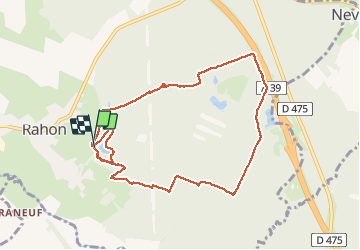
Tour Nordic Walking von 10,5 km verfügbar auf Burgund und Freigrafschaft, Jura, Rahon. Diese Tour wird von albert39 vorgeschlagen.
Beschreibung
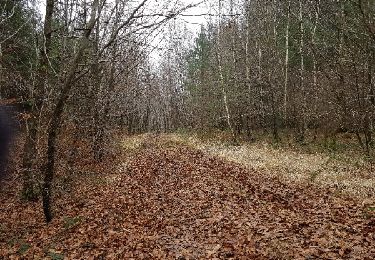
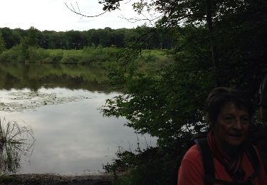
Départ parcours de santé, traversé bois de Rahon, chemin blanc le long de l'autoroute, retour par les étangs (2 tours) au parking.
Ort
Land:
France
Region :
Burgund und Freigrafschaft
Abteilung/Provinz :
Jura
Kommune :
Rahon
Standort:
Unknown
Gehen Sie:(Dec)
Gehen Sie:(UTM)
687843 ; 5206691 (31T) N.
Kommentare
Touren in der Umgebung
![Tour Nordic Walking Rahon - Rahon - N. D. du Bois - Photo](https://media.geolcdn.com/t/375/260/ext.jpg?maxdim=2&url=https%3A%2F%2Fservices.sitytrail.com%2FGeolivesWS%2FDownloadMedia.ashx%3FTrailID%3D244447%26Media%3Dfix__20140124140057.jpg)
![Nordic Walking Nordic Walking](https://static1.geolcdn.com/sitytour/trail-icons/102.png)
Rahon - N. D. du Bois
Nordic Walking
Schwierig
Rahon,
Burgund und Freigrafschaft,
Jura,
France
![](/images/other/stat-length.png)
8,8 km | 10 km-effort
2h 0min
![](https://static1.geolcdn.com/siteimages/upload/files/16400158638029165_repeat_loop_refresh_sync_direction_icon.png)
Ja
![Tour Wandern Rahon - Rahon 23 octobre 24 - Photo](https://media.geolcdn.com/t/375/260/ext.jpg?maxdim=2&url=https%3A%2F%2Fstatic1.geolcdn.com%2Fsiteimages%2Fupload%2Ffiles%2F1553511878bg_sport_marche.png)
![Wandern Wandern](https://static1.geolcdn.com/sitytour/trail-icons/101.png)
Rahon 23 octobre 24
Wandern
Einfach
Rahon,
Burgund und Freigrafschaft,
Jura,
France
![](/images/other/stat-length.png)
8,3 km | 9,5 km-effort
2h 21min
![](https://static1.geolcdn.com/siteimages/upload/files/16400158638029165_repeat_loop_refresh_sync_direction_icon.png)
Nein
![Tour Wandern Rahon - rahon - Photo](https://media.geolcdn.com/t/375/260/ext.jpg?maxdim=2&url=https%3A%2F%2Fstatic1.geolcdn.com%2Fsiteimages%2Fupload%2Ffiles%2F1553511878bg_sport_marche.png)
![Wandern Wandern](https://static1.geolcdn.com/sitytour/trail-icons/101.png)
rahon
Wandern
Einfach
Rahon,
Burgund und Freigrafschaft,
Jura,
France
![](/images/other/stat-length.png)
11,7 km | 13,5 km-effort
3h 6min
![](https://static1.geolcdn.com/siteimages/upload/files/16400158638029165_repeat_loop_refresh_sync_direction_icon.png)
Ja
![Tour Wandern Nevy-lès-Dole - Nevy Lès Dole 13 km 20191219 - Photo](https://media.geolcdn.com/t/375/260/ext.jpg?maxdim=2&url=https%3A%2F%2Fstatic1.geolcdn.com%2Fsiteimages%2Fupload%2Ffiles%2F1553511878bg_sport_marche.png)
![Wandern Wandern](https://static1.geolcdn.com/sitytour/trail-icons/101.png)
Nevy Lès Dole 13 km 20191219
Wandern
Sehr leicht
Nevy-lès-Dole,
Burgund und Freigrafschaft,
Jura,
France
![](/images/other/stat-length.png)
13,4 km | 15 km-effort
3h 19min
![](https://static1.geolcdn.com/siteimages/upload/files/16400158638029165_repeat_loop_refresh_sync_direction_icon.png)
Ja
![Tour Nordic Walking Rahon - Rahon 20171205 - Photo](https://media.geolcdn.com/t/375/260/ext.jpg?maxdim=2&url=https%3A%2F%2Fservices.sitytrail.com%2FGeolivesWS%2FDownloadMedia.ashx%3FTrailID%3D871877%26Media%3Dfix__20171205103852.jpg)
![Nordic Walking Nordic Walking](https://static1.geolcdn.com/sitytour/trail-icons/102.png)
Rahon 20171205
Nordic Walking
Sehr leicht
Rahon,
Burgund und Freigrafschaft,
Jura,
France
![](/images/other/stat-length.png)
9,5 km | 10,8 km-effort
2h 3min
![](https://static1.geolcdn.com/siteimages/upload/files/16400158638029165_repeat_loop_refresh_sync_direction_icon.png)
Ja
![Tour Wandern Nevy-lès-Dole - Nevy les Dole 13.8 km 20161222 - Photo](https://media.geolcdn.com/t/375/260/ext.jpg?maxdim=2&url=https%3A%2F%2Fstatic1.geolcdn.com%2Fsiteimages%2Fupload%2Ffiles%2F1553511878bg_sport_marche.png)
![Wandern Wandern](https://static1.geolcdn.com/sitytour/trail-icons/101.png)
Nevy les Dole 13.8 km 20161222
Wandern
Sehr leicht
Nevy-lès-Dole,
Burgund und Freigrafschaft,
Jura,
France
![](/images/other/stat-length.png)
13,8 km | 15,7 km-effort
3h 26min
![](https://static1.geolcdn.com/siteimages/upload/files/16400158638029165_repeat_loop_refresh_sync_direction_icon.png)
Ja
![Tour Wandern Le Deschaux - Le Deschaux 13.2km 20170105 - Photo](https://media.geolcdn.com/t/375/260/ext.jpg?maxdim=2&url=https%3A%2F%2Fstatic1.geolcdn.com%2Fsiteimages%2Fupload%2Ffiles%2F1553511878bg_sport_marche.png)
![Wandern Wandern](https://static1.geolcdn.com/sitytour/trail-icons/101.png)
Le Deschaux 13.2km 20170105
Wandern
Sehr leicht
Le Deschaux,
Burgund und Freigrafschaft,
Jura,
France
![](/images/other/stat-length.png)
13,2 km | 14,7 km-effort
3h 14min
![](https://static1.geolcdn.com/siteimages/upload/files/16400158638029165_repeat_loop_refresh_sync_direction_icon.png)
Ja
![Tour Wandern Le Deschaux - Le deschaux 13.3km 20160128 - Photo](https://media.geolcdn.com/t/375/260/ext.jpg?maxdim=2&url=https%3A%2F%2Fstatic1.geolcdn.com%2Fsiteimages%2Fupload%2Ffiles%2F1553511878bg_sport_marche.png)
![Wandern Wandern](https://static1.geolcdn.com/sitytour/trail-icons/101.png)
Le deschaux 13.3km 20160128
Wandern
Sehr leicht
Le Deschaux,
Burgund und Freigrafschaft,
Jura,
France
![](/images/other/stat-length.png)
13,3 km | 14,8 km-effort
3h 14min
![](https://static1.geolcdn.com/siteimages/upload/files/16400158638029165_repeat_loop_refresh_sync_direction_icon.png)
Ja
![Tour Nordic Walking Nevy-lès-Dole - Nevy les Dole - Photo](https://media.geolcdn.com/t/375/260/ext.jpg?maxdim=2&url=https%3A%2F%2Fservices.sitytrail.com%2FGeolivesWS%2FDownloadMedia.ashx%3FTrailID%3D306328%26Media%3D20140526105130.jpg)
![Nordic Walking Nordic Walking](https://static1.geolcdn.com/sitytour/trail-icons/102.png)
Nevy les Dole
Nordic Walking
Sehr leicht
Nevy-lès-Dole,
Burgund und Freigrafschaft,
Jura,
France
![](/images/other/stat-length.png)
12,7 km | 14,6 km-effort
2h 50min
![](https://static1.geolcdn.com/siteimages/upload/files/16400158638029165_repeat_loop_refresh_sync_direction_icon.png)
Ja