![](/images/other/stat-length.png)
![Tour Wandern La Riche - La Riche - Photo](https://media.geolcdn.com/t/1900/400/ext.pjpeg?maxdim=2&url=https%3A%2F%2Fstatic1.geolcdn.com%2Fsiteimages%2Fupload%2Ffiles%2F1553511878bg_sport_marche.png)
La Riche
LEMENIO
Benutzer
![Länge](/images/other/stat-length.png)
Länge
11,9 km
![Maximale Höhe](https://static1.geolcdn.com/siteimages/upload/files/1508320355ic_sort_altitude_max_24dp.png)
Maximale Höhe
53 m
![Positive Höhendifferenz](https://static1.geolcdn.com/siteimages/upload/files/1508320355ic_sort_den_pos_24dp.png)
Positive Höhendifferenz
70 m
![Km-Effort](/images/other/stat-length.png)
Km-Effort
12,8 km
![Min. Höhe](https://static1.geolcdn.com/siteimages/upload/files/1508320355ic_sort_altitude_min_24dp.png)
Min. Höhe
41 m
![Negative Höhendifferenz](https://static1.geolcdn.com/siteimages/upload/files/1508320355ic_sort_den_neg_24dp.png)
Negative Höhendifferenz
70 m
![Boucle](https://static1.geolcdn.com/siteimages/upload/files/16400158638029165_repeat_loop_refresh_sync_direction_icon.png)
Boucle
Ja
Erstellungsdatum :
2014-12-10 00:00:00.0
Letzte Änderung :
2014-12-10 00:00:00.0
![Wandern](https://static1.geolcdn.com/sitytour/trail-icons/101.png)
3h00
Schwierigkeit : Einfach
![Scannen Sie diesen QR-Code, um die Tour in der SityTrail-Anwendung zu öffnen](https://capi.geolives.com/qq0zvz2zws4bq2lad0pu/sitytour/trails/181489/qr.png?size=200)
Kostenlosegpshiking-Anwendung
Über SityTrail
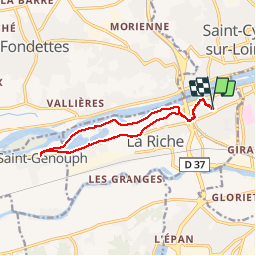
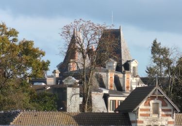
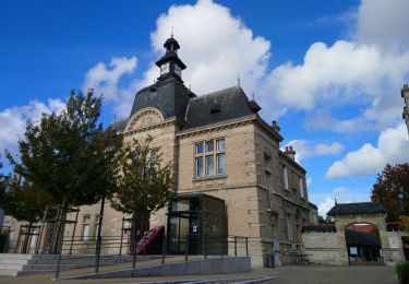
Tour Wandern von 11,9 km verfügbar auf Zentrum-Loiretal, Indre-et-Loire, La Riche. Diese Tour wird von LEMENIO vorgeschlagen.
Beschreibung
Départ place de la mairie : en début de rando, tourner à gauche en direction de la balise (sens de la rando).
Ort
Land:
France
Region :
Zentrum-Loiretal
Abteilung/Provinz :
Indre-et-Loire
Kommune :
La Riche
Standort:
Unknown
Gehen Sie:(Dec)
Gehen Sie:(UTM)
323201 ; 5251056 (31T) N.
Kommentare
Touren in der Umgebung
![Tour Wandern Tours - Tours - Marmoutier GR3 GR655 Rochecorbon - 8.2km 105m 1h50 - 2021 10 09 - Photo](https://media.geolcdn.com/t/375/260/8eec29df-bf69-4696-8607-c35bff826c99.jpg&format=jpg&maxdim=2)
![Wandern Wandern](https://static1.geolcdn.com/sitytour/trail-icons/101.png)
Tours - Marmoutier GR3 GR655 Rochecorbon - 8.2km 105m 1h50 - 2021 10 09
Wandern
Sehr leicht
(1)
Tours,
Zentrum-Loiretal,
Indre-et-Loire,
France
![](/images/other/stat-length.png)
8,2 km | 9,6 km-effort
1h 50min
![](https://static1.geolcdn.com/siteimages/upload/files/16400158638029165_repeat_loop_refresh_sync_direction_icon.png)
Ja
![Tour Wandern Fondettes - Fondettes Vallières - Luynes Le Vieux-Bourg - 26.1km 360m 5h30 (45mn) - 2024 12 11 - Photo](https://media.geolcdn.com/t/375/260/7ea9ad8d-3a09-4814-97d4-258e1355629e.jpg&format=jpg&maxdim=2)
![Wandern Wandern](https://static1.geolcdn.com/sitytour/trail-icons/101.png)
Fondettes Vallières - Luynes Le Vieux-Bourg - 26.1km 360m 5h30 (45mn) - 2024 ...
Wandern
Medium
Fondettes,
Zentrum-Loiretal,
Indre-et-Loire,
France
![](/images/other/stat-length.png)
26 km | 31 km-effort
5h 30min
![](https://static1.geolcdn.com/siteimages/upload/files/16400158638029165_repeat_loop_refresh_sync_direction_icon.png)
Ja
![Tour Wandern Fondettes - Fondettes Gare - Saint-Cyr-sur-Loire Tours - 23.4km 345m 5h10 (40mn) - 2024 10 27 - Photo](https://media.geolcdn.com/t/375/260/8177205d-60d4-4a9b-baf6-cca40bb2f1c5.jpg&format=jpg&maxdim=2)
![Wandern Wandern](https://static1.geolcdn.com/sitytour/trail-icons/101.png)
Fondettes Gare - Saint-Cyr-sur-Loire Tours - 23.4km 345m 5h10 (40mn) - 2024 1...
Wandern
Einfach
Fondettes,
Zentrum-Loiretal,
Indre-et-Loire,
France
![](/images/other/stat-length.png)
23 km | 28 km-effort
5h 10min
![](https://static1.geolcdn.com/siteimages/upload/files/16400158638029165_repeat_loop_refresh_sync_direction_icon.png)
Ja
![Tour Wandern Saint-Cyr-sur-Loire - Saint-Cyr-sur-Loire la Gagnerie - la Membrolle-sur-Choisille Mettray - 24km 405m 5h15 (50mn) - 2024 10 20 - Photo](https://media.geolcdn.com/t/375/260/21cd2b46-14f0-4eaa-a3c8-0e5f8e58cc4a.jpg&format=jpg&maxdim=2)
![Wandern Wandern](https://static1.geolcdn.com/sitytour/trail-icons/101.png)
Saint-Cyr-sur-Loire la Gagnerie - la Membrolle-sur-Choisille Mettray - 24km 4...
Wandern
Medium
Saint-Cyr-sur-Loire,
Zentrum-Loiretal,
Indre-et-Loire,
France
![](/images/other/stat-length.png)
24 km | 29 km-effort
5h 15min
![](https://static1.geolcdn.com/siteimages/upload/files/16400158638029165_repeat_loop_refresh_sync_direction_icon.png)
Ja
![Tour Wandern Fondettes - Fondettes Charcenay - Sentier Val de Choisille avec variantes - 23.5km 335m 5h10 (55mn) - 2024 10 13 - Photo](https://media.geolcdn.com/t/375/260/da5cdfb1-5871-4878-b704-e11c5bcbf000.jpg&format=jpg&maxdim=2)
![Wandern Wandern](https://static1.geolcdn.com/sitytour/trail-icons/101.png)
Fondettes Charcenay - Sentier Val de Choisille avec variantes - 23.5km 335m 5...
Wandern
Einfach
Fondettes,
Zentrum-Loiretal,
Indre-et-Loire,
France
![](/images/other/stat-length.png)
23 km | 28 km-effort
5h 10min
![](https://static1.geolcdn.com/siteimages/upload/files/16400158638029165_repeat_loop_refresh_sync_direction_icon.png)
Ja
![Tour Wandern Ballan-Miré - Ballan-Miré - Parking des Châtaigniers - 8.4km 125m 1h50 - 2024 03 06 - Photo](https://media.geolcdn.com/t/375/260/1a378f68-cb26-4349-9743-c95ed818731a.jpg&format=jpg&maxdim=2)
![Wandern Wandern](https://static1.geolcdn.com/sitytour/trail-icons/101.png)
Ballan-Miré - Parking des Châtaigniers - 8.4km 125m 1h50 - 2024 03 06
Wandern
Medium
Ballan-Miré,
Zentrum-Loiretal,
Indre-et-Loire,
France
![](/images/other/stat-length.png)
8,4 km | 10,1 km-effort
1h 50min
![](https://static1.geolcdn.com/siteimages/upload/files/16400158638029165_repeat_loop_refresh_sync_direction_icon.png)
Ja
![Tour Wandern Ballan-Miré - Ballan-Miré - Rochefuret - 13.7km 165m 3h05 (40mn) - 2024 03 06 - Photo](https://media.geolcdn.com/t/375/260/93e9015c-42ae-478f-b582-30ba0ec9c262.jpg&format=jpg&maxdim=2)
![Wandern Wandern](https://static1.geolcdn.com/sitytour/trail-icons/101.png)
Ballan-Miré - Rochefuret - 13.7km 165m 3h05 (40mn) - 2024 03 06
Wandern
Medium
Ballan-Miré,
Zentrum-Loiretal,
Indre-et-Loire,
France
![](/images/other/stat-length.png)
13,7 km | 16 km-effort
3h 5min
![](https://static1.geolcdn.com/siteimages/upload/files/16400158638029165_repeat_loop_refresh_sync_direction_icon.png)
Ja
![Tour Wandern Saint-Pierre-des-Corps - Saint-Pierre-des-Corps - PR Sentier du bord de Loire avec variantes - 13.6km 75m 2h55 (30mn) - 2023 10 22 - Photo](https://media.geolcdn.com/t/375/260/6a165834-3cba-4860-930a-9c6f29b052c7.jpg&format=jpg&maxdim=2)
![Wandern Wandern](https://static1.geolcdn.com/sitytour/trail-icons/101.png)
Saint-Pierre-des-Corps - PR Sentier du bord de Loire avec variantes - 13.6km ...
Wandern
Einfach
Saint-Pierre-des-Corps,
Zentrum-Loiretal,
Indre-et-Loire,
France
![](/images/other/stat-length.png)
13,6 km | 14,7 km-effort
2h 55min
![](https://static1.geolcdn.com/siteimages/upload/files/16400158638029165_repeat_loop_refresh_sync_direction_icon.png)
Ja
![Tour Wandern Tours - Tours - Bd Béranger La Riche - 8.8km 45m 2h00 - 2022 09 12 - Photo](https://media.geolcdn.com/t/375/260/42e96b35-6e0b-4b51-82b8-ef6cff621515.jpg&format=jpg&maxdim=2)
![Wandern Wandern](https://static1.geolcdn.com/sitytour/trail-icons/101.png)
Tours - Bd Béranger La Riche - 8.8km 45m 2h00 - 2022 09 12
Wandern
Sehr leicht
Tours,
Zentrum-Loiretal,
Indre-et-Loire,
France
![](/images/other/stat-length.png)
8,8 km | 9,4 km-effort
2h 0min
![](https://static1.geolcdn.com/siteimages/upload/files/16400158638029165_repeat_loop_refresh_sync_direction_icon.png)
Ja