![](/images/other/stat-length.png)
![Tour Andere Aktivitäten Andermatt - SCA-00-Sentier culturel des Alpes - Est - Photo](https://media.geolcdn.com/t/1900/400/ext.pjpeg?maxdim=2&url=https%3A%2F%2Fstatic1.geolcdn.com%2Fsiteimages%2Fupload%2Ffiles%2F1545311037marcheuse_200dpi.jpg)
SCA-00-Sentier culturel des Alpes - Est
Dgubler
Benutzer
![Länge](/images/other/stat-length.png)
Länge
214 km
![Maximale Höhe](https://static1.geolcdn.com/siteimages/upload/files/1508320355ic_sort_altitude_max_24dp.png)
Maximale Höhe
2764 m
![Positive Höhendifferenz](https://static1.geolcdn.com/siteimages/upload/files/1508320355ic_sort_den_pos_24dp.png)
Positive Höhendifferenz
21709 m
![Km-Effort](/images/other/stat-length.png)
Km-Effort
504 km
![Min. Höhe](https://static1.geolcdn.com/siteimages/upload/files/1508320355ic_sort_altitude_min_24dp.png)
Min. Höhe
560 m
![Negative Höhendifferenz](https://static1.geolcdn.com/siteimages/upload/files/1508320355ic_sort_den_neg_24dp.png)
Negative Höhendifferenz
21969 m
![Boucle](https://static1.geolcdn.com/siteimages/upload/files/16400158638029165_repeat_loop_refresh_sync_direction_icon.png)
Boucle
Nein
Erstellungsdatum :
2014-12-11 00:00:00.0
Letzte Änderung :
2014-12-11 00:00:00.0
![Andere Aktivitäten](https://static1.geolcdn.com/sitytour/trail-icons/900.png)
--
Schwierigkeit : Unbekannt
![Scannen Sie diesen QR-Code, um die Tour in der SityTrail-Anwendung zu öffnen](https://capi.geolives.com/qq0zvz2zws4bq2lad0pu/sitytour/trails/18123/qr.png?size=200)
Kostenlosegpshiking-Anwendung
Über SityTrail
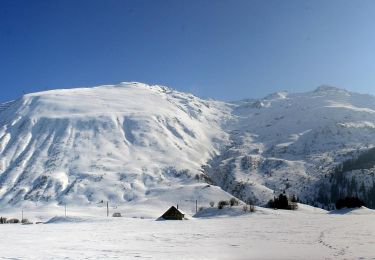
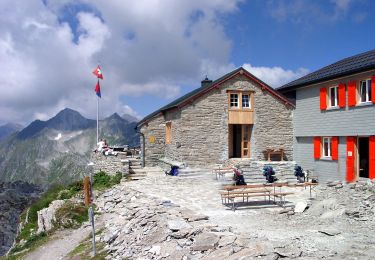
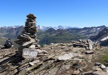
Tour Andere Aktivitäten von 214 km verfügbar auf Uri, Korporation Ursern, Andermatt. Diese Tour wird von Dgubler vorgeschlagen.
Beschreibung
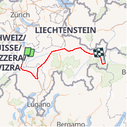
Le Sentier culturel des Alpes (une initiative des Amis de la Nature, www.amisdelanature.ch), moitié orientale, d''Andermatt à Müstair.
The Eastern half of the Swiss Alps Cultural Trail, from Andermatt to Müstair.
Ort
Land:
Switzerland
Region :
Uri
Abteilung/Provinz :
Korporation Ursern
Kommune :
Andermatt
Standort:
Unknown
Gehen Sie:(Dec)
Gehen Sie:(UTM)
469298 ; 5164430 (32T) N.
Kommentare
Touren in der Umgebung
![Tour Zu Fuß Andermatt - Kräuterlehrpfad Mur - Photo](https://media.geolcdn.com/t/375/260/23ebdf3d-6550-42a3-bdcb-791aa1e419ea.jpeg&format=jpg&maxdim=2)
![Zu Fuß Zu Fuß](https://static1.geolcdn.com/sitytour/trail-icons/100.png)
Kräuterlehrpfad Mur
Zu Fuß
Einfach
Andermatt,
Uri,
Korporation Ursern,
Switzerland
![](/images/other/stat-length.png)
7,6 km | 10,5 km-effort
2h 23min
![](https://static1.geolcdn.com/siteimages/upload/files/16400158638029165_repeat_loop_refresh_sync_direction_icon.png)
Nein
![Tour Zu Fuß Andermatt - Blumen- und Lawinenlehrpfad Chilchenberg - Photo](https://media.geolcdn.com/t/375/260/23ebdf3d-6550-42a3-bdcb-791aa1e419ea.jpeg&format=jpg&maxdim=2)
![Zu Fuß Zu Fuß](https://static1.geolcdn.com/sitytour/trail-icons/100.png)
Blumen- und Lawinenlehrpfad Chilchenberg
Zu Fuß
Einfach
Andermatt,
Uri,
Korporation Ursern,
Switzerland
![](/images/other/stat-length.png)
3,9 km | 8,4 km-effort
1h 54min
![](https://static1.geolcdn.com/siteimages/upload/files/16400158638029165_repeat_loop_refresh_sync_direction_icon.png)
Nein
![Tour Zu Fuß Andermatt - Schöni - Pazolalücke - Photo](https://media.geolcdn.com/t/375/260/d1617093-8655-46c4-9467-a0f549651cea.jpeg&format=jpg&maxdim=2)
![Zu Fuß Zu Fuß](https://static1.geolcdn.com/sitytour/trail-icons/100.png)
Schöni - Pazolalücke
Zu Fuß
Einfach
Andermatt,
Uri,
Korporation Ursern,
Switzerland
![](/images/other/stat-length.png)
3,7 km | 10,3 km-effort
2h 20min
![](https://static1.geolcdn.com/siteimages/upload/files/16400158638029165_repeat_loop_refresh_sync_direction_icon.png)
Nein
![Tour Zu Fuß Andermatt - Stöckli - Steglaui Riental - Photo](https://media.geolcdn.com/t/375/260/18a6a89b-b2db-4bc5-bdbd-b09a3baf89d4.jpeg&format=jpg&maxdim=2)
![Zu Fuß Zu Fuß](https://static1.geolcdn.com/sitytour/trail-icons/100.png)
Stöckli - Steglaui Riental
Zu Fuß
Einfach
Andermatt,
Uri,
Korporation Ursern,
Switzerland
![](/images/other/stat-length.png)
6,7 km | 11,2 km-effort
2h 33min
![](https://static1.geolcdn.com/siteimages/upload/files/16400158638029165_repeat_loop_refresh_sync_direction_icon.png)
Nein
![Tour Zu Fuß Andermatt - Golfrundweg - Photo](https://media.geolcdn.com/t/375/260/89334e40-d25e-499c-90c6-7d30e1b20946.jpeg&format=jpg&maxdim=2)
![Zu Fuß Zu Fuß](https://static1.geolcdn.com/sitytour/trail-icons/100.png)
Golfrundweg
Zu Fuß
Einfach
Andermatt,
Uri,
Korporation Ursern,
Switzerland
![](/images/other/stat-length.png)
5,6 km | 7,2 km-effort
1h 38min
![](https://static1.geolcdn.com/siteimages/upload/files/16400158638029165_repeat_loop_refresh_sync_direction_icon.png)
Ja
![Tour Zu Fuß Andermatt - Vermigel - Capanna Cadlimo - Photo](https://media.geolcdn.com/t/375/260/55e4726d-a963-4121-9825-2227d492a520.jpeg&format=jpg&maxdim=2)
![Zu Fuß Zu Fuß](https://static1.geolcdn.com/sitytour/trail-icons/100.png)
Vermigel - Capanna Cadlimo
Zu Fuß
Einfach
Andermatt,
Uri,
Korporation Ursern,
Switzerland
![](/images/other/stat-length.png)
7,4 km | 17,6 km-effort
4h 0min
![](https://static1.geolcdn.com/siteimages/upload/files/16400158638029165_repeat_loop_refresh_sync_direction_icon.png)
Nein
![Tour Zu Fuß Andermatt - Lago della Sella - Sunnsbühl - Photo](https://media.geolcdn.com/t/375/260/8dfbce18-3c5b-4b83-9802-71ce5e04d009.jpeg&format=jpg&maxdim=2)
![Zu Fuß Zu Fuß](https://static1.geolcdn.com/sitytour/trail-icons/100.png)
Lago della Sella - Sunnsbühl
Zu Fuß
Einfach
Andermatt,
Uri,
Korporation Ursern,
Switzerland
![](/images/other/stat-length.png)
5 km | 12,4 km-effort
2h 48min
![](https://static1.geolcdn.com/siteimages/upload/files/16400158638029165_repeat_loop_refresh_sync_direction_icon.png)
Nein
![Tour Zu Fuß Andermatt - Ursener Höhenweg - Photo](https://media.geolcdn.com/t/375/260/f7b36a6e-ed2a-4f4f-9e56-9c6f30267693.jpeg&format=jpg&maxdim=2)
![Zu Fuß Zu Fuß](https://static1.geolcdn.com/sitytour/trail-icons/100.png)
Ursener Höhenweg
Zu Fuß
Medium
Andermatt,
Uri,
Korporation Ursern,
Switzerland
![](/images/other/stat-length.png)
13,9 km | 26 km-effort
5h 49min
![](https://static1.geolcdn.com/siteimages/upload/files/16400158638029165_repeat_loop_refresh_sync_direction_icon.png)
Nein
![Tour Zu Fuß Andermatt - Andermatt - Vermigel - Photo](https://media.geolcdn.com/t/375/260/ext.jpg?maxdim=2&url=https%3A%2F%2Fstatic1.geolcdn.com%2Fsiteimages%2Fupload%2Ffiles%2F1545311037marcheuse_200dpi.jpg)
![Zu Fuß Zu Fuß](https://static1.geolcdn.com/sitytour/trail-icons/100.png)
Andermatt - Vermigel
Zu Fuß
Einfach
Andermatt,
Uri,
Korporation Ursern,
Switzerland
![](/images/other/stat-length.png)
5,5 km | 10,1 km-effort
2h 17min
![](https://static1.geolcdn.com/siteimages/upload/files/16400158638029165_repeat_loop_refresh_sync_direction_icon.png)
Nein