![](/images/other/stat-length.png)
![Tour Wandern Vouvray - VOUVRAY - Photo](https://media.geolcdn.com/t/1900/400/ext.pjpeg?maxdim=2&url=https%3A%2F%2Fstatic1.geolcdn.com%2Fsiteimages%2Fupload%2Ffiles%2F1553511878bg_sport_marche.png)
VOUVRAY
LEMENIO
Benutzer
![Länge](/images/other/stat-length.png)
![Maximale Höhe](https://static1.geolcdn.com/siteimages/upload/files/1508320355ic_sort_altitude_max_24dp.png)
![Positive Höhendifferenz](https://static1.geolcdn.com/siteimages/upload/files/1508320355ic_sort_den_pos_24dp.png)
![Km-Effort](/images/other/stat-length.png)
![Min. Höhe](https://static1.geolcdn.com/siteimages/upload/files/1508320355ic_sort_altitude_min_24dp.png)
![Negative Höhendifferenz](https://static1.geolcdn.com/siteimages/upload/files/1508320355ic_sort_den_neg_24dp.png)
![Boucle](https://static1.geolcdn.com/siteimages/upload/files/16400158638029165_repeat_loop_refresh_sync_direction_icon.png)
![Wandern](https://static1.geolcdn.com/sitytour/trail-icons/101.png)
2h48
Schwierigkeit : Medium
![Scannen Sie diesen QR-Code, um die Tour in der SityTrail-Anwendung zu öffnen](https://capi.geolives.com/qq0zvz2zws4bq2lad0pu/sitytour/trails/174017/qr.png?size=200)
Kostenlosegpshiking-Anwendung
Über SityTrail
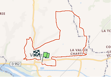
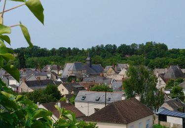
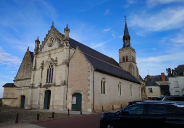
Tour Wandern von 11 km verfügbar auf Zentrum-Loiretal, Indre-et-Loire, Vouvray. Diese Tour wird von LEMENIO vorgeschlagen.
Beschreibung
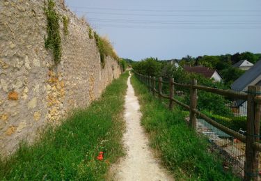
Départ Parking 2 avenue d Holnon Vouvray(près de l'école primaire) NB :sentier très pentu sur 50 mètres pour accéder au plateau. Par temps frais, prévoir un vêtement contre le vent du plateau.Fin de parcours intéressant et assez pittoresque(allée de l'échenau).
Ort
Kommentare
Touren in der Umgebung
![Tour Wandern Vernou-sur-Brenne - Vernou-sur-Brenne la Coudraie - Zig Zag Vaubrault Noizay - 27.1km 385m 5h55 (55mn) - 2024 11 03 - Photo](https://media.geolcdn.com/t/375/260/9c945cd3-c4f0-44b2-b00c-aa0430042429.jpg&format=jpg&maxdim=2)
![Wandern Wandern](https://static1.geolcdn.com/sitytour/trail-icons/101.png)
Wandern
![](/images/other/stat-length.png)
![](https://static1.geolcdn.com/siteimages/upload/files/16400158638029165_repeat_loop_refresh_sync_direction_icon.png)
![Tour Wandern Montlouis-sur-Loire - Montlouis-sur-Loire - gare GR41 Veretz Azay-sur-Cher - 13km 85m 2h45 - 2023 10 07 - Photo](https://media.geolcdn.com/t/375/260/0a795f12-7cb8-451f-a494-3acd28ec6c5f.jpg&format=jpg&maxdim=2)
![Wandern Wandern](https://static1.geolcdn.com/sitytour/trail-icons/101.png)
Wandern
![](/images/other/stat-length.png)
![](https://static1.geolcdn.com/siteimages/upload/files/16400158638029165_repeat_loop_refresh_sync_direction_icon.png)
![Tour Wandern Parçay-Meslay - Parcay-Meslay - lieu-dit le Houdeau de Monnaie - 21.3km 190m 4h50 (50mn) - 2023 08 27 - Photo](https://media.geolcdn.com/t/375/260/12319d71-2676-4fa6-b6d8-bd3dc55c96dc.jpg&format=jpg&maxdim=2)
![Wandern Wandern](https://static1.geolcdn.com/sitytour/trail-icons/101.png)
Wandern
![](/images/other/stat-length.png)
![](https://static1.geolcdn.com/siteimages/upload/files/16400158638029165_repeat_loop_refresh_sync_direction_icon.png)
![Tour Wandern Montlouis-sur-Loire - Montlouis-sur-Loire - PR Sur les pas de Gabrielle d'Estrées - 9.5km 100m 2h20 - 2023 07 08 - Photo](https://media.geolcdn.com/t/375/260/b211a3c9-f8d2-42f6-bf4b-d2bf5553a450.jpg&format=jpg&maxdim=2)
![Wandern Wandern](https://static1.geolcdn.com/sitytour/trail-icons/101.png)
Wandern
![](/images/other/stat-length.png)
![](https://static1.geolcdn.com/siteimages/upload/files/16400158638029165_repeat_loop_refresh_sync_direction_icon.png)
![Tour Wandern Vouvray - Vouvray - PR balisé en bleu - 15.1km 125m 3h30 - 2023 06 28 - Photo](https://media.geolcdn.com/t/375/260/60d19163-b23a-4217-bba8-93e697ea97cd.jpg&format=jpg&maxdim=2)
![Wandern Wandern](https://static1.geolcdn.com/sitytour/trail-icons/101.png)
Wandern
![](/images/other/stat-length.png)
![](https://static1.geolcdn.com/siteimages/upload/files/16400158638029165_repeat_loop_refresh_sync_direction_icon.png)
![Tour Wandern Vernou-sur-Brenne - Vernou-sur-Brenne - Variante Sentier Vignes et Patrimoine - 10.9km 140m 2h30 (25mn) - 2023 06 28 - Photo](https://media.geolcdn.com/t/375/260/1dfb41e2-d3bf-47c9-be6e-516142895db1.jpg&format=jpg&maxdim=2)
![Wandern Wandern](https://static1.geolcdn.com/sitytour/trail-icons/101.png)
Wandern
![](/images/other/stat-length.png)
![](https://static1.geolcdn.com/siteimages/upload/files/16400158638029165_repeat_loop_refresh_sync_direction_icon.png)
![Tour Radtourismus Montlouis-sur-Loire - De Montlouis sur Loire à Villandry - Photo](https://media.geolcdn.com/t/375/260/06e7a589-0b86-4225-a7bb-150a85f87cea.jpg&format=jpg&maxdim=2)
![Radtourismus Radtourismus](https://static1.geolcdn.com/sitytour/trail-icons/204.png)
Radtourismus
![](/images/other/stat-length.png)
![](https://static1.geolcdn.com/siteimages/upload/files/16400158638029165_repeat_loop_refresh_sync_direction_icon.png)
![Tour Wandern Vernou-sur-Brenne - Vaugondy Vernou - Reugny - 24.9km 315m 5h30 (30mn) - 2022 11 13 - Photo](https://media.geolcdn.com/t/375/260/13d5da4a-d9d8-42a7-9c90-4a29acd213f5.jpg&format=jpg&maxdim=2)
![Wandern Wandern](https://static1.geolcdn.com/sitytour/trail-icons/101.png)
Wandern
![](/images/other/stat-length.png)
![](https://static1.geolcdn.com/siteimages/upload/files/16400158638029165_repeat_loop_refresh_sync_direction_icon.png)
![Tour Wandern Montlouis-sur-Loire - Montlouis-sur-Loire - Entre Loire et vignes GR3 GR655est - 17.4km 190m 3h55 - 2022 10 16 - Photo](https://media.geolcdn.com/t/375/260/e654fc0b-8c0f-40ae-a5a9-a83b98260b2c.jpg&format=jpg&maxdim=2)
![Wandern Wandern](https://static1.geolcdn.com/sitytour/trail-icons/101.png)
Wandern
![](/images/other/stat-length.png)
![](https://static1.geolcdn.com/siteimages/upload/files/16400158638029165_repeat_loop_refresh_sync_direction_icon.png)