![](/images/other/stat-length.png)
![Tour Wandern Saint-Chef - Randonnée autour de Saint Chef - Photo](https://media.geolcdn.com/t/1900/400/ext.pjpeg?maxdim=2&url=https%3A%2F%2Fservices.sitytrail.com%2FGeolivesWS%2FDownloadMedia.ashx%3FTrailID%3D173262%26Media%3D14880_2.jpg)
Randonnée autour de Saint Chef
tracegps
Benutzer
![Länge](/images/other/stat-length.png)
Länge
10,3 km
![Maximale Höhe](https://static1.geolcdn.com/siteimages/upload/files/1508320355ic_sort_altitude_max_24dp.png)
Maximale Höhe
427 m
![Positive Höhendifferenz](https://static1.geolcdn.com/siteimages/upload/files/1508320355ic_sort_den_pos_24dp.png)
Positive Höhendifferenz
158 m
![Km-Effort](/images/other/stat-length.png)
Km-Effort
12,4 km
![Min. Höhe](https://static1.geolcdn.com/siteimages/upload/files/1508320355ic_sort_altitude_min_24dp.png)
Min. Höhe
321 m
![Negative Höhendifferenz](https://static1.geolcdn.com/siteimages/upload/files/1508320355ic_sort_den_neg_24dp.png)
Negative Höhendifferenz
151 m
![Boucle](https://static1.geolcdn.com/siteimages/upload/files/16400158638029165_repeat_loop_refresh_sync_direction_icon.png)
Boucle
Ja
Erstellungsdatum :
2014-12-10 00:00:00.0
Letzte Änderung :
2014-12-10 00:00:00.0
![Wandern](https://static1.geolcdn.com/sitytour/trail-icons/101.png)
3h45
Schwierigkeit : Einfach
![Scannen Sie diesen QR-Code, um die Tour in der SityTrail-Anwendung zu öffnen](https://capi.geolives.com/qq0zvz2zws4bq2lad0pu/sitytour/trails/173262/qr.png?size=200)
Kostenlosegpshiking-Anwendung
Über SityTrail
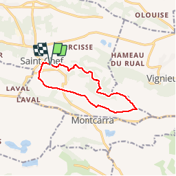
Tour Wandern von 10,3 km verfügbar auf Auvergne-Rhone-Alpen, Isère, Saint-Chef. Diese Tour wird von tracegps vorgeschlagen.
Beschreibung
Il s'agit du circuit "bleu" tracé par le Syndicat d'Initiative de la commune de Saint Chef. Distance théorique: 12 km. Distance réelle 10.3 km et dénivelée de 215m.
Ort
Land:
France
Region :
Auvergne-Rhone-Alpen
Abteilung/Provinz :
Isère
Kommune :
Saint-Chef
Standort:
Unknown
Gehen Sie:(Dec)
Gehen Sie:(UTM)
684703 ; 5055972 (31T) N.
Kommentare
Touren in der Umgebung
![Tour Wandern Saint-Chef - Promenade 2022/02/13 - Photo](https://media.geolcdn.com/t/375/260/a2501420-db13-4b70-96e9-ad6164180d66.jpg&format=jpg&maxdim=2)
![Wandern Wandern](https://static1.geolcdn.com/sitytour/trail-icons/101.png)
Promenade 2022/02/13
Wandern
Medium
Saint-Chef,
Auvergne-Rhone-Alpen,
Isère,
France
![](/images/other/stat-length.png)
6,9 km | 8,9 km-effort
1h 23min
![](https://static1.geolcdn.com/siteimages/upload/files/16400158638029165_repeat_loop_refresh_sync_direction_icon.png)
Ja
![Tour Wandern Vignieu - Vignieu - Saint Chef - Canal des moines - Photo](https://media.geolcdn.com/t/375/260/ext.jpg?maxdim=2&url=https%3A%2F%2Fstatic1.geolcdn.com%2Fsiteimages%2Fupload%2Ffiles%2F1553511878bg_sport_marche.png)
![Wandern Wandern](https://static1.geolcdn.com/sitytour/trail-icons/101.png)
Vignieu - Saint Chef - Canal des moines
Wandern
Sehr schwierig
Vignieu,
Auvergne-Rhone-Alpen,
Isère,
France
![](/images/other/stat-length.png)
15,6 km | 20 km-effort
4h 34min
![](https://static1.geolcdn.com/siteimages/upload/files/16400158638029165_repeat_loop_refresh_sync_direction_icon.png)
Ja
![Tour Wandern Saint-Chef - Courses Saint-Chef - 20220222 - Photo](https://media.geolcdn.com/t/375/260/ext.jpg?maxdim=2&url=https%3A%2F%2Fstatic1.geolcdn.com%2Fsiteimages%2Fupload%2Ffiles%2F1553511878bg_sport_marche.png)
![Wandern Wandern](https://static1.geolcdn.com/sitytour/trail-icons/101.png)
Courses Saint-Chef - 20220222
Wandern
Einfach
Saint-Chef,
Auvergne-Rhone-Alpen,
Isère,
France
![](/images/other/stat-length.png)
4,4 km | 5 km-effort
45min
![](https://static1.geolcdn.com/siteimages/upload/files/16400158638029165_repeat_loop_refresh_sync_direction_icon.png)
Ja
![Tour Wandern Saint-Chef - Saint chef 2 - Photo](https://media.geolcdn.com/t/375/260/ext.jpg?maxdim=2&url=https%3A%2F%2Fstatic1.geolcdn.com%2Fsiteimages%2Fupload%2Ffiles%2F1553511878bg_sport_marche.png)
![Wandern Wandern](https://static1.geolcdn.com/sitytour/trail-icons/101.png)
Saint chef 2
Wandern
Sehr leicht
(1)
Saint-Chef,
Auvergne-Rhone-Alpen,
Isère,
France
![](/images/other/stat-length.png)
9,6 km | 12,5 km-effort
3h 3min
![](https://static1.geolcdn.com/siteimages/upload/files/16400158638029165_repeat_loop_refresh_sync_direction_icon.png)
Ja
![Tour Wandern Montcarra - Sur les hauteurs de Montcarra - Photo](https://media.geolcdn.com/t/375/260/ext.jpg?maxdim=2&url=https%3A%2F%2Fstatic1.geolcdn.com%2Fsiteimages%2Fupload%2Ffiles%2F1553511878bg_sport_marche.png)
![Wandern Wandern](https://static1.geolcdn.com/sitytour/trail-icons/101.png)
Sur les hauteurs de Montcarra
Wandern
Einfach
(1)
Montcarra,
Auvergne-Rhone-Alpen,
Isère,
France
![](/images/other/stat-length.png)
6,8 km | 8 km-effort
1h 44min
![](https://static1.geolcdn.com/siteimages/upload/files/16400158638029165_repeat_loop_refresh_sync_direction_icon.png)
Ja
![Tour Wandern Saint-Savin - st savin - Photo](https://media.geolcdn.com/t/375/260/ext.jpg?maxdim=2&url=https%3A%2F%2Fstatic1.geolcdn.com%2Fsiteimages%2Fupload%2Ffiles%2F1553511878bg_sport_marche.png)
![Wandern Wandern](https://static1.geolcdn.com/sitytour/trail-icons/101.png)
st savin
Wandern
Sehr leicht
Saint-Savin,
Auvergne-Rhone-Alpen,
Isère,
France
![](/images/other/stat-length.png)
9,9 km | 13,4 km-effort
2h 16min
![](https://static1.geolcdn.com/siteimages/upload/files/16400158638029165_repeat_loop_refresh_sync_direction_icon.png)
Nein
![Tour sport Saint-Chef - Rando saint chef - Photo](https://media.geolcdn.com/t/375/260/ext.jpg?maxdim=2&url=https%3A%2F%2Fsecurestorage.geolives.com%2Fsitytour%2Ftrail-bg%2Fdefault.jpg)
Rando saint chef
sport
Sehr leicht
Saint-Chef,
Auvergne-Rhone-Alpen,
Isère,
France
![](/images/other/stat-length.png)
10,4 km | 12,6 km-effort
Unbekannt
![](https://static1.geolcdn.com/siteimages/upload/files/16400158638029165_repeat_loop_refresh_sync_direction_icon.png)
Nein
![Tour Wandern Vignieu - vigneu chevaux - Photo](https://media.geolcdn.com/t/375/260/ext.jpg?maxdim=2&url=https%3A%2F%2Fstatic1.geolcdn.com%2Fsiteimages%2Fupload%2Ffiles%2F1553511878bg_sport_marche.png)
![Wandern Wandern](https://static1.geolcdn.com/sitytour/trail-icons/101.png)
vigneu chevaux
Wandern
Sehr leicht
Vignieu,
Auvergne-Rhone-Alpen,
Isère,
France
![](/images/other/stat-length.png)
3,6 km | 4,3 km-effort
1h 26min
![](https://static1.geolcdn.com/siteimages/upload/files/16400158638029165_repeat_loop_refresh_sync_direction_icon.png)
Ja
![Tour Mountainbike Saint-Savin - st savin - Photo](https://media.geolcdn.com/t/375/260/ext.jpg?maxdim=2&url=https%3A%2F%2Fstatic1.geolcdn.com%2Fsiteimages%2Fupload%2Ffiles%2F1524743154velo.jpg)
![Mountainbike Mountainbike](https://static1.geolcdn.com/sitytour/trail-icons/202.png)
st savin
Mountainbike
Schwierig
Saint-Savin,
Auvergne-Rhone-Alpen,
Isère,
France
![](/images/other/stat-length.png)
51 km | 65 km-effort
3h 32min
![](https://static1.geolcdn.com/siteimages/upload/files/16400158638029165_repeat_loop_refresh_sync_direction_icon.png)
Ja
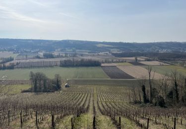
Tres joli paysages. Randonnée accessible.