![](/images/other/stat-length.png)
![Tour Wandern Longpré-les-Corps-Saints - Le circuit des cours d'eau - Longpré les Corps Saints - Photo](https://media.geolcdn.com/t/1900/400/ext.pjpeg?maxdim=2&url=https%3A%2F%2Fservices.sitytrail.com%2FGeolivesWS%2FDownloadMedia.ashx%3FTrailID%3D173255%26Media%3D14869_3.jpg)
Le circuit des cours d'eau - Longpré les Corps Saints
tracegps
Benutzer
![Länge](/images/other/stat-length.png)
![Maximale Höhe](https://static1.geolcdn.com/siteimages/upload/files/1508320355ic_sort_altitude_max_24dp.png)
![Positive Höhendifferenz](https://static1.geolcdn.com/siteimages/upload/files/1508320355ic_sort_den_pos_24dp.png)
![Km-Effort](/images/other/stat-length.png)
![Min. Höhe](https://static1.geolcdn.com/siteimages/upload/files/1508320355ic_sort_altitude_min_24dp.png)
![Negative Höhendifferenz](https://static1.geolcdn.com/siteimages/upload/files/1508320355ic_sort_den_neg_24dp.png)
![Boucle](https://static1.geolcdn.com/siteimages/upload/files/16400158638029165_repeat_loop_refresh_sync_direction_icon.png)
![Wandern](https://static1.geolcdn.com/sitytour/trail-icons/101.png)
1h30
Schwierigkeit : Medium
![Scannen Sie diesen QR-Code, um die Tour in der SityTrail-Anwendung zu öffnen](https://capi.geolives.com/qq0zvz2zws4bq2lad0pu/sitytour/trails/173255/qr.png?size=200)
Kostenlosegpshiking-Anwendung
Über SityTrail
Tour Wandern von 4,9 km verfügbar auf Nordfrankreich, Somme, Longpré-les-Corps-Saints. Diese Tour wird von tracegps vorgeschlagen.
Beschreibung
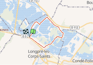
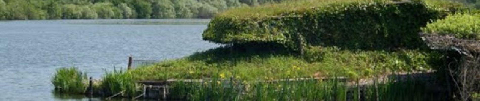
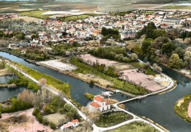
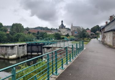
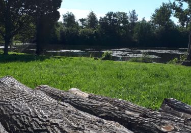
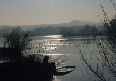
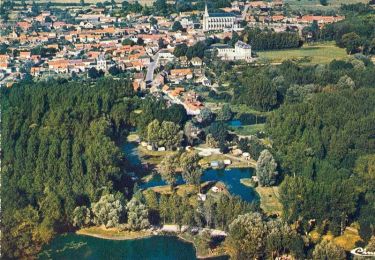
Situé au cœur de la vallée de la Somme, le circuit de Longpré-les-Corps-Saints est un formidable point de départ pour une excursion nature ! Partez à la découverte de la faune et de la flore de ce lieu unique ! Depuis le parking de la Maison du marais, empruntez le chemin qui longe le grand étang. À la surface de l’eau, les nénuphars jaunes et blancs constituent un garde-manger de premier choix pour les oiseaux d’eau: les hérons et les Grèbes huppés ne s’y trompent pas et viennent y prélever leur repas quotidien. Prenez ensuite sur la droite en traversant le pont pour continuer sur le chemin bordé de roselières ponctuées de frênes et de saules cendrés... Téléchargez la fiche du circuit.
Ort
Kommentare
Touren in der Umgebung
![Tour Wandern Long - L'écluse et la centrale hydroélectrique - Long - Photo](https://media.geolcdn.com/t/375/260/ext.jpg?maxdim=2&url=https%3A%2F%2Fservices.sitytrail.com%2FGeolivesWS%2FDownloadMedia.ashx%3FTrailID%3D110473%26Media%3D5989_6.jpg)
![Wandern Wandern](https://static1.geolcdn.com/sitytour/trail-icons/101.png)
Wandern
![](/images/other/stat-length.png)
![](https://static1.geolcdn.com/siteimages/upload/files/16400158638029165_repeat_loop_refresh_sync_direction_icon.png)
![Tour Wandern Long - long bleue 9km - Photo](https://media.geolcdn.com/t/375/260/89b8b5e6-56c9-4922-964d-87c8f198f560.jpg&format=jpg&maxdim=2)
![Wandern Wandern](https://static1.geolcdn.com/sitytour/trail-icons/101.png)
Wandern
![](/images/other/stat-length.png)
![](https://static1.geolcdn.com/siteimages/upload/files/16400158638029165_repeat_loop_refresh_sync_direction_icon.png)
![Tour Zu Fuß Condé-Folie - Les Marais de Condé-Folie - Photo](https://media.geolcdn.com/t/375/260/835fcbd3-aace-47a4-b88d-70695e4b8706.jpeg&format=jpg&maxdim=2)
![Zu Fuß Zu Fuß](https://static1.geolcdn.com/sitytour/trail-icons/100.png)
Zu Fuß
![](/images/other/stat-length.png)
![](https://static1.geolcdn.com/siteimages/upload/files/16400158638029165_repeat_loop_refresh_sync_direction_icon.png)
![Tour Zu Fuß Longpré-les-Corps-Saints - Le Circuit des Cours d'Eau - Photo](https://media.geolcdn.com/t/375/260/0092ca74-c815-4988-81a6-9840359e6184.jpeg&format=jpg&maxdim=2)
![Zu Fuß Zu Fuß](https://static1.geolcdn.com/sitytour/trail-icons/100.png)
Zu Fuß
![](/images/other/stat-length.png)
![](https://static1.geolcdn.com/siteimages/upload/files/16400158638029165_repeat_loop_refresh_sync_direction_icon.png)
![Tour Zu Fuß Long - Les Bords de Somme - Photo](https://media.geolcdn.com/t/375/260/524a8fde-e553-41eb-af37-bc359713a178.jpeg&format=jpg&maxdim=2)
![Zu Fuß Zu Fuß](https://static1.geolcdn.com/sitytour/trail-icons/100.png)
Zu Fuß
![](/images/other/stat-length.png)
![](https://static1.geolcdn.com/siteimages/upload/files/16400158638029165_repeat_loop_refresh_sync_direction_icon.png)
![Tour Zu Fuß Fontaine-sur-Somme - Les Hauts de Long - Photo](https://media.geolcdn.com/t/375/260/857ea661-13e1-4088-8b62-d697c76652e3.jpeg&format=jpg&maxdim=2)
![Zu Fuß Zu Fuß](https://static1.geolcdn.com/sitytour/trail-icons/100.png)
Zu Fuß
![](/images/other/stat-length.png)
![](https://static1.geolcdn.com/siteimages/upload/files/16400158638029165_repeat_loop_refresh_sync_direction_icon.png)
![Tour Wandern Long - Une randonnée rythmée par les étangs. - Photo](https://media.geolcdn.com/t/375/260/07cc8282-85e0-46da-9260-ab7cedc0be52.jpg&format=jpg&maxdim=2)
![Wandern Wandern](https://static1.geolcdn.com/sitytour/trail-icons/101.png)
Wandern
![](/images/other/stat-length.png)
![](https://static1.geolcdn.com/siteimages/upload/files/16400158638029165_repeat_loop_refresh_sync_direction_icon.png)
![Tour Mountainbike Long - Circuit autour de Long - Photo](https://media.geolcdn.com/t/375/260/ext.jpg?maxdim=2&url=https%3A%2F%2Fservices.sitytrail.com%2FGeolivesWS%2FDownloadMedia.ashx%3FTrailID%3D110555%26Media%3D6111_6.jpg)
![Mountainbike Mountainbike](https://static1.geolcdn.com/sitytour/trail-icons/202.png)
Mountainbike
![](/images/other/stat-length.png)
![](https://static1.geolcdn.com/siteimages/upload/files/16400158638029165_repeat_loop_refresh_sync_direction_icon.png)
![Tour Wandern Long - Promenade n° 2 à Long - Photo](https://media.geolcdn.com/t/375/260/ext.jpg?maxdim=2&url=https%3A%2F%2Fservices.sitytrail.com%2FGeolivesWS%2FDownloadMedia.ashx%3FTrailID%3D110554%26Media%3D6110_3.jpg)
![Wandern Wandern](https://static1.geolcdn.com/sitytour/trail-icons/101.png)
Wandern
![](/images/other/stat-length.png)
![](https://static1.geolcdn.com/siteimages/upload/files/16400158638029165_repeat_loop_refresh_sync_direction_icon.png)