![](/images/other/stat-length.png)
![Tour Wandern Arvieux - Le Tour du Queyras (Furfande - Bramousse) - Photo](https://media.geolcdn.com/t/1900/400/ext.pjpeg?maxdim=2&url=https%3A%2F%2Fservices.sitytrail.com%2FGeolivesWS%2FDownloadMedia.ashx%3FTrailID%3D173178%26Media%3D14759_2.jpg)
Le Tour du Queyras (Furfande - Bramousse)
tracegps
Benutzer
![Länge](/images/other/stat-length.png)
![Maximale Höhe](https://static1.geolcdn.com/siteimages/upload/files/1508320355ic_sort_altitude_max_24dp.png)
![Positive Höhendifferenz](https://static1.geolcdn.com/siteimages/upload/files/1508320355ic_sort_den_pos_24dp.png)
![Km-Effort](/images/other/stat-length.png)
![Min. Höhe](https://static1.geolcdn.com/siteimages/upload/files/1508320355ic_sort_altitude_min_24dp.png)
![Negative Höhendifferenz](https://static1.geolcdn.com/siteimages/upload/files/1508320355ic_sort_den_neg_24dp.png)
![Boucle](https://static1.geolcdn.com/siteimages/upload/files/16400158638029165_repeat_loop_refresh_sync_direction_icon.png)
![Wandern](https://static1.geolcdn.com/sitytour/trail-icons/101.png)
3h00
Schwierigkeit : Medium
![Scannen Sie diesen QR-Code, um die Tour in der SityTrail-Anwendung zu öffnen](https://capi.geolives.com/qq0zvz2zws4bq2lad0pu/sitytour/trails/173178/qr.png?size=200)
Kostenlosegpshiking-Anwendung
Über SityTrail
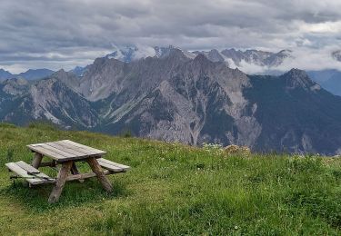
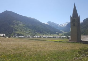
Tour Wandern von 8,9 km verfügbar auf Provence-Alpes-Côte d'Azur, Hochalpen, Arvieux. Diese Tour wird von tracegps vorgeschlagen.
Beschreibung
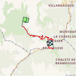
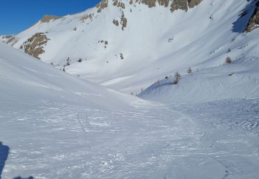
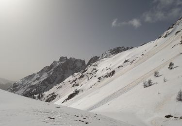
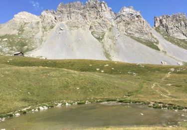
Etape 4: En quittant le refuge de Furfande sous la crête de Croseras, levez le nez vers les pierriers et les alpages; les chamois y passent souvent la nuit et sont peut-être encore là. On commence par un trajet sud-est en balcon puis la descente commence vraiment en lacets globalement en direction de l’est. On franchit le torrent de la Lauze, on laisse sur la gauche un premier sentier rejoignant Villargaudin et Arvieux puis un second et on profite de la belle vue sur la vallée du Guil. On arrive aux Escoyères par de jolis tronçons de sentiers nouvellement aménagés (nous sommes passés en août 2012) : merci les baliseurs ! On laisse le chemin de Montbardon filer vers le nord-est et on pique vers le sud direction les Esponces. Là on trouve à nouveau des tronçons tout neufs qui permettent d’éviter une bonne partie de route goudronnée. On débouche sur la D902 qu’on suit direction sud-est jusqu’au pont de Bramousse qui franchit le Guil. Après le pont, un sentier sur la droite monte à Bramousse.
Ort
Kommentare
Touren in der Umgebung
![Tour Wandern Arvieux - les alpages de Furfande - Photo](https://media.geolcdn.com/t/375/260/ext.jpg?maxdim=2&url=https%3A%2F%2Fservices.sitytrail.com%2FGeolivesWS%2FDownloadMedia.ashx%3FTrailID%3D818492%26Media%3Dfix__20170827130418.jpg)
![Wandern Wandern](https://static1.geolcdn.com/sitytour/trail-icons/101.png)
Wandern
![](/images/other/stat-length.png)
![](https://static1.geolcdn.com/siteimages/upload/files/16400158638029165_repeat_loop_refresh_sync_direction_icon.png)
![Tour Wandern Guillestre - 2024-11-05 Bramousse - Photo](https://media.geolcdn.com/t/375/260/d238ebb4-60bc-45fe-8b14-7e13a6a17b11.jpg&format=jpg&maxdim=2)
![Wandern Wandern](https://static1.geolcdn.com/sitytour/trail-icons/101.png)
Wandern
![](/images/other/stat-length.png)
![](https://static1.geolcdn.com/siteimages/upload/files/16400158638029165_repeat_loop_refresh_sync_direction_icon.png)
![Tour Schneeschuhwandern Arvieux - Arvieux- Col de Furfande - Photo](https://media.geolcdn.com/t/375/260/9dfc15e0-52ef-46ec-b577-723d411025c1.jpg&format=jpg&maxdim=2)
![Schneeschuhwandern Schneeschuhwandern](https://static1.geolcdn.com/sitytour/trail-icons/504.png)
Schneeschuhwandern
![](/images/other/stat-length.png)
![](https://static1.geolcdn.com/siteimages/upload/files/16400158638029165_repeat_loop_refresh_sync_direction_icon.png)
![Tour Wandern Arvieux - Furfande - Photo](https://media.geolcdn.com/t/375/260/a7b25990-6529-4fcf-960e-f9d8e5c42968.jpg&format=jpg&maxdim=2)
![Wandern Wandern](https://static1.geolcdn.com/sitytour/trail-icons/101.png)
Wandern
![](/images/other/stat-length.png)
![](https://static1.geolcdn.com/siteimages/upload/files/16400158638029165_repeat_loop_refresh_sync_direction_icon.png)
![Tour Schneeschuhwandern Arvieux - villardgaudin - Photo](https://media.geolcdn.com/t/375/260/eef6e6cd-413d-473a-a997-acd5344e8fff.jpg&format=jpg&maxdim=2)
![Schneeschuhwandern Schneeschuhwandern](https://static1.geolcdn.com/sitytour/trail-icons/504.png)
Schneeschuhwandern
![](/images/other/stat-length.png)
![](https://static1.geolcdn.com/siteimages/upload/files/16400158638029165_repeat_loop_refresh_sync_direction_icon.png)
![Tour Wandern Arvieux - Com de Fontouse - Photo](https://media.geolcdn.com/t/375/260/e06c623d-ecf4-4af0-bde2-0bb4469522fa.jpg&format=jpg&maxdim=2)
![Wandern Wandern](https://static1.geolcdn.com/sitytour/trail-icons/101.png)
Wandern
![](/images/other/stat-length.png)
![](https://static1.geolcdn.com/siteimages/upload/files/16400158638029165_repeat_loop_refresh_sync_direction_icon.png)
![Tour Wandern Arvieux - 05 Le tour de la dent du Ratier Queyras - Photo](https://media.geolcdn.com/t/375/260/a8108fe2-da80-4d05-b0ff-d01aa3b946ac.jpg&format=jpg&maxdim=2)
![Wandern Wandern](https://static1.geolcdn.com/sitytour/trail-icons/101.png)
Wandern
![](/images/other/stat-length.png)
![](https://static1.geolcdn.com/siteimages/upload/files/16400158638029165_repeat_loop_refresh_sync_direction_icon.png)
![Tour Schlittenhunde Guillestre - Charmousse. Ceillac - Photo](https://media.geolcdn.com/t/375/260/22e65922-80a9-44d1-8671-c17703851575.jpg&format=jpg&maxdim=2)
![Schlittenhunde Schlittenhunde](https://static1.geolcdn.com/sitytour/trail-icons/505.png)
Schlittenhunde
![](/images/other/stat-length.png)
![](https://static1.geolcdn.com/siteimages/upload/files/16400158638029165_repeat_loop_refresh_sync_direction_icon.png)
![Tour Mountainbike Arvieux - Q3 Arvieux - Lac de la Roue - Souliers - Photo](https://media.geolcdn.com/t/375/260/ext.jpg?maxdim=2&url=https%3A%2F%2Fservices.sitytrail.com%2FGeolivesWS%2FDownloadMedia.ashx%3FTrailID%3D609496%26Media%3Dfix__20160803113621.jpg)
![Mountainbike Mountainbike](https://static1.geolcdn.com/sitytour/trail-icons/202.png)
Mountainbike
![](/images/other/stat-length.png)
![](https://static1.geolcdn.com/siteimages/upload/files/16400158638029165_repeat_loop_refresh_sync_direction_icon.png)