![](/images/other/stat-length.png)
![Tour Mountainbike Angos - Angos - Sarouilles - Lac de l'Arrêt Darré - Photo](https://media.geolcdn.com/t/1900/400/ext.pjpeg?maxdim=2&url=https%3A%2F%2Fservices.sitytrail.com%2FGeolivesWS%2FDownloadMedia.ashx%3FTrailID%3D173031%26Media%3D14543_2.jpg)
Angos - Sarouilles - Lac de l'Arrêt Darré
tracegps
Benutzer
![Länge](/images/other/stat-length.png)
Länge
26 km
![Maximale Höhe](https://static1.geolcdn.com/siteimages/upload/files/1508320355ic_sort_altitude_max_24dp.png)
Maximale Höhe
434 m
![Positive Höhendifferenz](https://static1.geolcdn.com/siteimages/upload/files/1508320355ic_sort_den_pos_24dp.png)
Positive Höhendifferenz
573 m
![Km-Effort](/images/other/stat-length.png)
Km-Effort
34 km
![Min. Höhe](https://static1.geolcdn.com/siteimages/upload/files/1508320355ic_sort_altitude_min_24dp.png)
Min. Höhe
244 m
![Negative Höhendifferenz](https://static1.geolcdn.com/siteimages/upload/files/1508320355ic_sort_den_neg_24dp.png)
Negative Höhendifferenz
575 m
![Boucle](https://static1.geolcdn.com/siteimages/upload/files/16400158638029165_repeat_loop_refresh_sync_direction_icon.png)
Boucle
Ja
Erstellungsdatum :
2014-12-10 00:00:00.0
Letzte Änderung :
2014-12-10 00:00:00.0
![Mountainbike](https://static1.geolcdn.com/sitytour/trail-icons/202.png)
1h49
Schwierigkeit : Schwierig
![Scannen Sie diesen QR-Code, um die Tour in der SityTrail-Anwendung zu öffnen](https://capi.geolives.com/qq0zvz2zws4bq2lad0pu/sitytour/trails/173031/qr.png?size=200)
Kostenlosegpshiking-Anwendung
Über SityTrail
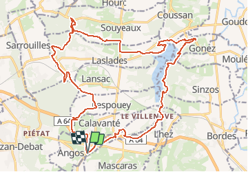
Tour Mountainbike von 26 km verfügbar auf Okzitanien, Hautes-Pyrénées, Angos. Diese Tour wird von tracegps vorgeschlagen.
Beschreibung
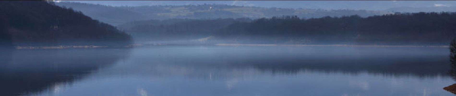
Circuit varié avec une vue imprenable sur les Pyrénées depuis le Lac du l'Arrêt Darré. Il est d'une difficulté que je qualifierai de Moyenne , la difficulté étant fonction du niveau de forme de chacun. Mon Etrex affichait 541m de dénivelé. Bonne balade.
Ort
Land:
France
Region :
Okzitanien
Abteilung/Provinz :
Hautes-Pyrénées
Kommune :
Angos
Standort:
Unknown
Gehen Sie:(Dec)
Gehen Sie:(UTM)
268998 ; 4786280 (31T) N.
Kommentare
Touren in der Umgebung
![Tour Wandern Lhez - lhezlespontsfaif - Photo](https://media.geolcdn.com/t/375/260/ext.jpg?maxdim=2&url=https%3A%2F%2Fservices.sitytrail.com%2FGeolivesWS%2FDownloadMedia.ashx%3FTrailID%3D919394%26Media%3Dfix__20180308184351.jpg)
![Wandern Wandern](https://static1.geolcdn.com/sitytour/trail-icons/101.png)
lhezlespontsfaif
Wandern
Sehr leicht
(1)
Lhez,
Okzitanien,
Hautes-Pyrénées,
France
![](/images/other/stat-length.png)
11,6 km | 14,9 km-effort
3h 15min
![](https://static1.geolcdn.com/siteimages/upload/files/16400158638029165_repeat_loop_refresh_sync_direction_icon.png)
Ja
![Tour Wandern Lhez - lhezlespontsfaif - Photo](https://media.geolcdn.com/t/375/260/ext.jpg?maxdim=2&url=https%3A%2F%2Fservices.sitytrail.com%2FGeolivesWS%2FDownloadMedia.ashx%3FTrailID%3D989266%26Media%3Dfix__20180308184351.jpg)
![Wandern Wandern](https://static1.geolcdn.com/sitytour/trail-icons/101.png)
lhezlespontsfaif
Wandern
Sehr leicht
Lhez,
Okzitanien,
Hautes-Pyrénées,
France
![](/images/other/stat-length.png)
11,6 km | 14,9 km-effort
3h 15min
![](https://static1.geolcdn.com/siteimages/upload/files/16400158638029165_repeat_loop_refresh_sync_direction_icon.png)
Ja
![Tour Zu Fuß Barbazan-Debat - Le Bois de Rebisclou - Photo](https://media.geolcdn.com/t/375/260/0953bc9f-744d-418a-bbb1-ae0b8beb8cae.jpeg&format=jpg&maxdim=2)
![Zu Fuß Zu Fuß](https://static1.geolcdn.com/sitytour/trail-icons/100.png)
Le Bois de Rebisclou
Zu Fuß
Einfach
Barbazan-Debat,
Okzitanien,
Hautes-Pyrénées,
France
![](/images/other/stat-length.png)
9,6 km | 12,7 km-effort
2h 53min
![](https://static1.geolcdn.com/siteimages/upload/files/16400158638029165_repeat_loop_refresh_sync_direction_icon.png)
Ja
![Tour Wandern Lhez - Lhez-Les ponts G4 fait en 2021 - Photo](https://media.geolcdn.com/t/375/260/79d492d5-d685-4dae-a0dc-edadd3762085.jpg&format=jpg&maxdim=2)
![Wandern Wandern](https://static1.geolcdn.com/sitytour/trail-icons/101.png)
Lhez-Les ponts G4 fait en 2021
Wandern
Schwierig
Lhez,
Okzitanien,
Hautes-Pyrénées,
France
![](/images/other/stat-length.png)
11,2 km | 14,4 km-effort
3h 22min
![](https://static1.geolcdn.com/siteimages/upload/files/16400158638029165_repeat_loop_refresh_sync_direction_icon.png)
Ja
![Tour Wandern Bernac-Debat - bernac les deux fait - Photo](https://media.geolcdn.com/t/375/260/1e412c3f-5b4b-4f0d-a7ad-8d93d1e3b864.jpg&format=jpg&maxdim=2)
![Wandern Wandern](https://static1.geolcdn.com/sitytour/trail-icons/101.png)
bernac les deux fait
Wandern
Sehr leicht
Bernac-Debat,
Okzitanien,
Hautes-Pyrénées,
France
![](/images/other/stat-length.png)
7,8 km | 9,2 km-effort
2h 40min
![](https://static1.geolcdn.com/siteimages/upload/files/16400158638029165_repeat_loop_refresh_sync_direction_icon.png)
Ja
![Tour Wandern Lhez - lhezfaiapied - Photo](https://media.geolcdn.com/t/375/260/ext.jpg?maxdim=2&url=https%3A%2F%2Fservices.sitytrail.com%2FGeolivesWS%2FDownloadMedia.ashx%3FTrailID%3D1010375%26Media%3Dfix__20180725094559.jpg)
![Wandern Wandern](https://static1.geolcdn.com/sitytour/trail-icons/101.png)
lhezfaiapied
Wandern
Sehr leicht
Lhez,
Okzitanien,
Hautes-Pyrénées,
France
![](/images/other/stat-length.png)
9,5 km | 12,4 km-effort
2h 59min
![](https://static1.geolcdn.com/siteimages/upload/files/16400158638029165_repeat_loop_refresh_sync_direction_icon.png)
Ja
![Tour Wandern Séméac - la barthe circuit rouge - Photo](https://media.geolcdn.com/t/375/260/ext.jpg?maxdim=2&url=https%3A%2F%2Fservices.sitytrail.com%2FGeolivesWS%2FDownloadMedia.ashx%3FTrailID%3D324256%26Media%3D20140714174851.jpg)
![Wandern Wandern](https://static1.geolcdn.com/sitytour/trail-icons/101.png)
la barthe circuit rouge
Wandern
Sehr leicht
Séméac,
Okzitanien,
Hautes-Pyrénées,
France
![](/images/other/stat-length.png)
3,4 km | 4,7 km-effort
59min
![](https://static1.geolcdn.com/siteimages/upload/files/16400158638029165_repeat_loop_refresh_sync_direction_icon.png)
Ja
![Tour Wandern Lhez - LHEZG42021 - Photo](https://media.geolcdn.com/t/375/260/a2a5ad57-a158-4fc3-be5b-dbf324450cde.jpg&format=jpg&maxdim=2)
![Wandern Wandern](https://static1.geolcdn.com/sitytour/trail-icons/101.png)
LHEZG42021
Wandern
Medium
Lhez,
Okzitanien,
Hautes-Pyrénées,
France
![](/images/other/stat-length.png)
7,9 km | 9,7 km-effort
5h 22min
![](https://static1.geolcdn.com/siteimages/upload/files/16400158638029165_repeat_loop_refresh_sync_direction_icon.png)
Ja
![Tour Wandern Lhez - lhez les ponts G4 2022 - Photo](https://media.geolcdn.com/t/375/260/323386f1-786c-43c9-99b7-c835ae2b29f4.jpg&format=jpg&maxdim=2)
![Wandern Wandern](https://static1.geolcdn.com/sitytour/trail-icons/101.png)
lhez les ponts G4 2022
Wandern
Schwierig
Lhez,
Okzitanien,
Hautes-Pyrénées,
France
![](/images/other/stat-length.png)
11,9 km | 15,5 km-effort
5h 17min
![](https://static1.geolcdn.com/siteimages/upload/files/16400158638029165_repeat_loop_refresh_sync_direction_icon.png)
Ja