![](/images/other/stat-length.png)
![Tour Wandern Murat - La Via Arverna (Murat - Saint Jacques des Blats) - Photo](https://media.geolcdn.com/t/1900/400/ext.pjpeg?maxdim=2&url=https%3A%2F%2Fservices.sitytrail.com%2FGeolivesWS%2FDownloadMedia.ashx%3FTrailID%3D173009%26Media%3D14510_6.jpg)
La Via Arverna (Murat - Saint Jacques des Blats)
tracegps
Benutzer
![Länge](/images/other/stat-length.png)
![Maximale Höhe](https://static1.geolcdn.com/siteimages/upload/files/1508320355ic_sort_altitude_max_24dp.png)
![Positive Höhendifferenz](https://static1.geolcdn.com/siteimages/upload/files/1508320355ic_sort_den_pos_24dp.png)
![Km-Effort](/images/other/stat-length.png)
![Min. Höhe](https://static1.geolcdn.com/siteimages/upload/files/1508320355ic_sort_altitude_min_24dp.png)
![Negative Höhendifferenz](https://static1.geolcdn.com/siteimages/upload/files/1508320355ic_sort_den_neg_24dp.png)
![Boucle](https://static1.geolcdn.com/siteimages/upload/files/16400158638029165_repeat_loop_refresh_sync_direction_icon.png)
![Wandern](https://static1.geolcdn.com/sitytour/trail-icons/101.png)
8h00
Schwierigkeit : Schwierig
![Scannen Sie diesen QR-Code, um die Tour in der SityTrail-Anwendung zu öffnen](https://capi.geolives.com/qq0zvz2zws4bq2lad0pu/sitytour/trails/173009/qr.png?size=200)
Kostenlosegpshiking-Anwendung
Über SityTrail
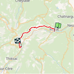
Tour Wandern von 27 km verfügbar auf Auvergne-Rhone-Alpen, Cantal, Murat. Diese Tour wird von tracegps vorgeschlagen.
Beschreibung
Etape 10 de la via Arverna, chemin de Saint Jacques de Compostelle entre Clermont-Ferrand et Cahors. Etape de montagne avec une élévation progressive pour atteindre une altitude culminant à environ 1 700 m. Au cours de ce chemin, vous suivrez la GR 400 (« Tour des monts du Cantal ») jusqu’au Puy du Griou. Passage ou contournement de plusieurs sommets (Puy Griou, Téton de Venus, …). Les plus belles vues du chemin sont au rendez-vous. Au cours de cette étape, découverte des gentianes sur les hauteurs. Vous quitterez l’Alagnon pour découvrir la rivière de la Cère à l’arrivée au village de Saint-Jacques-des-Blats. Retrouvez l'étape n° 10 sur le site de la «Via Arverna - chemin Saint-Jacques-de-Compostelle» ainsi qu'ICI sur le site de la « Via Arverna ».
Ort
Kommentare
Touren in der Umgebung
![Tour Wandern Albepierre-Bredons - Cantal - Albepierre - les Cascades - 9.6km 330m 3h25 - 2019 06 23 - Photo](https://media.geolcdn.com/t/375/260/7c343e5b-9b79-4737-bf33-8f8bb008b3a2.jpg&format=jpg&maxdim=2)
![Wandern Wandern](https://static1.geolcdn.com/sitytour/trail-icons/101.png)
Wandern
![](/images/other/stat-length.png)
![](https://static1.geolcdn.com/siteimages/upload/files/16400158638029165_repeat_loop_refresh_sync_direction_icon.png)
![Tour Wandern Murat - les estives et tourbière de Chastel sur Murat - Photo](https://media.geolcdn.com/t/375/260/177cc3c3-d770-480f-901b-cbeaabf71678.jpg&format=jpg&maxdim=2)
![Wandern Wandern](https://static1.geolcdn.com/sitytour/trail-icons/101.png)
Wandern
![](/images/other/stat-length.png)
![](https://static1.geolcdn.com/siteimages/upload/files/16400158638029165_repeat_loop_refresh_sync_direction_icon.png)
![Tour Wandern Laveissière - Le lac Glory de Laveissière - Photo](https://media.geolcdn.com/t/375/260/ext.jpg?maxdim=2&url=https%3A%2F%2Fservices.sitytrail.com%2FGeolivesWS%2FDownloadMedia.ashx%3FTrailID%3D106468%26Media%3D10983_1.jpg)
![Wandern Wandern](https://static1.geolcdn.com/sitytour/trail-icons/101.png)
Wandern
![](/images/other/stat-length.png)
![](https://static1.geolcdn.com/siteimages/upload/files/16400158638029165_repeat_loop_refresh_sync_direction_icon.png)
![Tour Rennrad Albepierre-Bredons - cascades de Veyrines et lac du pêcher - Photo](https://media.geolcdn.com/t/375/260/51bbe222-68fd-40c8-b03d-d522f834567b.jpg&format=jpg&maxdim=2)
![Rennrad Rennrad](https://static1.geolcdn.com/sitytour/trail-icons/201.png)
Rennrad
![](/images/other/stat-length.png)
![](https://static1.geolcdn.com/siteimages/upload/files/16400158638029165_repeat_loop_refresh_sync_direction_icon.png)
![Tour Rennrad Albepierre-Bredons - Sanissage 5 cascades - Photo](https://media.geolcdn.com/t/375/260/85ecf86a-b278-4ee6-890b-5b284e817c7d.jpg&format=jpg&maxdim=2)
![Rennrad Rennrad](https://static1.geolcdn.com/sitytour/trail-icons/201.png)
Rennrad
![](/images/other/stat-length.png)
![](https://static1.geolcdn.com/siteimages/upload/files/16400158638029165_repeat_loop_refresh_sync_direction_icon.png)
![Tour Rennrad Albepierre-Bredons - Le puy Mary par St Jacques des blats retour Dienne - Photo](https://media.geolcdn.com/t/375/260/27e4b2a9-b34d-4064-9ff2-6d8b9b60bab0.jpg&format=jpg&maxdim=2)
![Rennrad Rennrad](https://static1.geolcdn.com/sitytour/trail-icons/201.png)
Rennrad
![](/images/other/stat-length.png)
![](https://static1.geolcdn.com/siteimages/upload/files/16400158638029165_repeat_loop_refresh_sync_direction_icon.png)
![Tour Pfad Albepierre-Bredons - Une partie des crêtes vers le Plomb du Cantal - Photo](https://media.geolcdn.com/t/375/260/721772bb-976e-40f4-94dd-71ce0a6e8753.jpg&format=jpg&maxdim=2)
![Pfad Pfad](https://static1.geolcdn.com/sitytour/trail-icons/104.png)
Pfad
![](/images/other/stat-length.png)
![](https://static1.geolcdn.com/siteimages/upload/files/16400158638029165_repeat_loop_refresh_sync_direction_icon.png)
![Tour Wandern Laveissière - Cantal - Cheyrouze (Laveissière) - Puy de Seycheuse - 14.8km 600m 5h35 - 2019 06 30 - Photo](https://media.geolcdn.com/t/375/260/9aa2826f-ab44-4435-96bc-4a2b060c1cbb.jpg&format=jpg&maxdim=2)
![Wandern Wandern](https://static1.geolcdn.com/sitytour/trail-icons/101.png)
Wandern
![](/images/other/stat-length.png)
![](https://static1.geolcdn.com/siteimages/upload/files/16400158638029165_repeat_loop_refresh_sync_direction_icon.png)
![Tour Wandern Albepierre-Bredons - Col de la Molède 9,3 km - Albepierre - Photo](https://media.geolcdn.com/t/375/260/4e9bd869-b560-46fe-9b86-9494c4288e90.jpg&format=jpg&maxdim=2)
![Wandern Wandern](https://static1.geolcdn.com/sitytour/trail-icons/101.png)
Wandern
![](/images/other/stat-length.png)
![](https://static1.geolcdn.com/siteimages/upload/files/16400158638029165_repeat_loop_refresh_sync_direction_icon.png)